Salta elevation
Salta, Argentina elevation is 1183 meters and Salta elevation in feet is 3881 ft above sea level [src 1]. Salta is a seat of a first-order administrative division (feature code) with elevation that is 833 meters (2733 ft) bigger than average city elevation in Argentina.
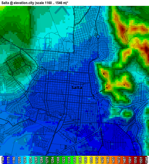
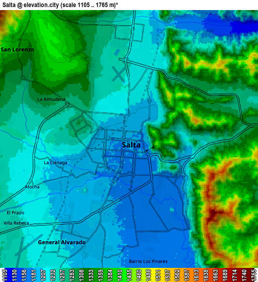
Below is the Elevation map of Salta, which displays elevation range with different colors. Scale of the first map is from 1160 to 1546 m (3806 to 5072 ft) with average elevation of 1228.8 meters (=4031 ft) [note 1]
These maps also provides idea of topography and contour of this city, they are displayed at different zoom levels. More info about maps, scale and edge coordinates you can find below images.
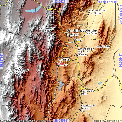
| \ | Map #1 | Map #2 | Topo.Map |
| Scale [m] | 1160..1546 m | 1105..1765 m | × |
| Scale [ft] | 3806..5072 ft | 3625..5791 ft | × |
| Average | 1228.8 m = 4031 ft | 1273.9 m = 4179 ft | × |
| Width | 8.87 km = 5.5 mi | 17.74 km = 11 mi | 283.9 km = 176.4 mi |
| Height | 8.87 km = 5.5 mi | 17.74 km = 11 mi | 283.9 km = 176.4 mi |
| ↑Max Latitude | -24.745996° | -24.70608° | -23.50271° |
| Latitude at center | -24.7859° | -24.7859° | -24.7859° |
| ↓Min Latitude | -24.825791° | -24.865669° | -26.05596° |
| ← Min Longitude | -65.455605° | -65.499551° | -66.81791° |
| Longitude center | -65.41166° | -65.41166° | -65.41166° |
| →Max Longitude | -65.367715° | -65.323769° | -64.00541° |
Nearby cities:
Cities around Salta sort by population:
• San Salvador de Jujuy elevation 1260 m
66.8 km,  9°
9°
• Palpalá 1126 m
62.2 km,  18°
18°
• El Carril 1168 m
33 km,  194°
194°
• Chicoana 1238 m
37.6 km,  199°
199°
• Campo Quijano 1501 m
26.5 km,  238°
238°
• Santa Rosa de Tastil 3220 m
68 km,  303°
303°
• San Antonio 1350 m
47.2 km, 9°
• El Carmen 1178 m
46.9 km, 18°
• General Martín Miguel de Güemes 742 m
38.9 km,  70°
70°
• Rosario de Lerma 1328 m
27.6 km,  217°
217°
• La Caldera 1389 m
20.4 km, 8°
• Cerrillos 1256 m
14.6 km,  211°
211°
Multilingual:
 En español:
Ciudad de Salta elevación 1183 m.
 En France:
Salta élévation 1183 m.


Sources and notes:
- [note 1] Map square and city borders are not equal. Map elevation data is calculated only from area inside that square.
- [src 1] Elevation data from geonames database provided with same terms of usage.
- [src 2] The elevation map of Salta is generated using elevation data from NASA's 3 arcsec (90m) resolution SRTM data.
- [src 3] Base (background) map © OpenStreetMap contributors tiles are generated by Geofabrik and OpenTopoMap.
Copyright & License:
This Salta Elevation Map is licensed under CC BY-SA. You may reuse any part from this page, if you give a proper credit by linking to this URL:
 More info on terms of use page.