Chicoana elevation
Chicoana (Salta, Departamento de Chicoana), Argentina elevation is 1238 meters and Chicoana elevation in feet is 4062 ft above sea level [src 1]. Chicoana is a seat of a second-order administrative division (feature code) with elevation that is 888 meters (2913 ft) bigger than average city elevation in Argentina.
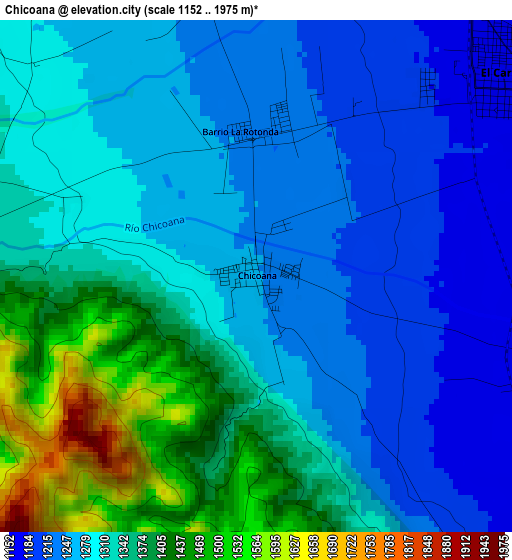
Below is the Elevation map of Chicoana, which displays elevation range with different colors. Scale of the first map is from 1152 to 1975 m (3780 to 6480 ft) with average elevation of 1311.5 meters (=4303 ft) [note 1]
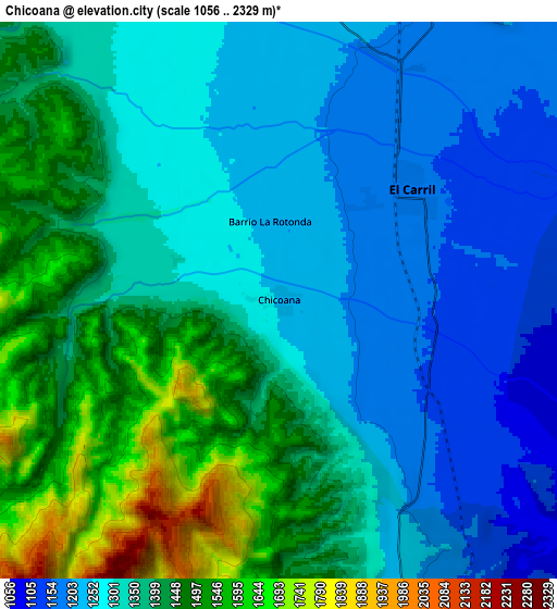
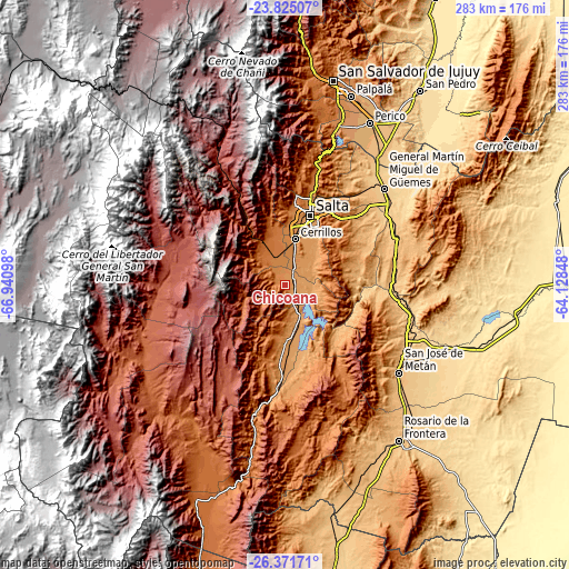
These maps also provides idea of topography and contour of this city, they are displayed at different zoom levels. More info about maps, scale and edge coordinates you can find below images.
| \ | Map #1 | Map #2 | Topo.Map |
| Scale [m] | 1152..1975 m | 1056..2329 m | × |
| Scale [ft] | 3780..6480 ft | 3465..7641 ft | × |
| Average | 1311.5 m = 4303 ft | 1352.9 m = 4439 ft | × |
| Width | 8.85 km = 5.5 mi | 17.7 km = 11 mi | 283.2 km = 176 mi |
| Height | 8.85 km = 5.5 mi | 17.7 km = 11 mi | 283.2 km = 176 mi |
| ↑Max Latitude | -25.06522° | -25.025406° | -23.82507° |
| Latitude at center | -25.10502° | -25.10502° | -25.10502° |
| ↓Min Latitude | -25.144807° | -25.184582° | -26.37171° |
| ← Min Longitude | -65.578675° | -65.622621° | -66.94098° |
| Longitude center | -65.53473° | -65.53473° | -65.53473° |
| →Max Longitude | -65.490785° | -65.446839° | -64.12848° |
Nearby cities:
Cities around Chicoana sort by population:
• Salta elevation 1183 m
37.6 km,  19°
19°
• El Carril 1168 m
5.5 km,  51°
51°
• Campo Quijano 1501 m
24 km,  334°
334°
• Cachí 2355 m
63.5 km,  268°
268°
• La Poma 3016 m
79.6 km,  302°
302°
• Metán 860 m
71.4 km,  127°
127°
• General Martín Miguel de Güemes 742 m
68.9 km, 45°
• La Caldera 1389 m
57.7 km, 15°
• Guachipas 1096 m
46.2 km,  176°
176°
• La Viña 1193 m
40.3 km, 184°
• Cerrillos 1256 m
23.5 km,  11°
11°
• Rosario de Lerma 1328 m
14.4 km,  341°
341°
Multilingual:
 En español:
Chicoana elevación 1238 m.
 En France:
Chicoana élévation 1238 m.
 Auf Deutsch:
Chicoana höhe über dem Meeresspiegel ist 1238 m.

Sources and notes:
- [note 1] Map square and city borders are not equal. Map elevation data is calculated only from area inside that square.
- [src 1] Elevation data from geonames database provided with same terms of usage.
- [src 2] The elevation map of Chicoana is generated using elevation data from NASA's 3 arcsec (90m) resolution SRTM data.
- [src 3] Base (background) map © OpenStreetMap contributors tiles are generated by Geofabrik and OpenTopoMap.
Copyright & License:
This Chicoana Elevation Map is licensed under CC BY-SA. You may reuse any part from this page, if you give a proper credit by linking to this URL:
 More info on terms of use page.