Abra Pampa elevation
Abra Pampa (Jujuy, Departamento de Cochinoca), Argentina elevation is 3487 meters and Abra Pampa elevation in feet is 11440 ft above sea level [src 1]. Abra Pampa is a seat of a second-order administrative division (feature code) with elevation that is 3137 meters (10292 ft) bigger than average city elevation in Argentina.
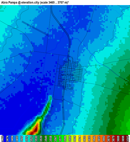
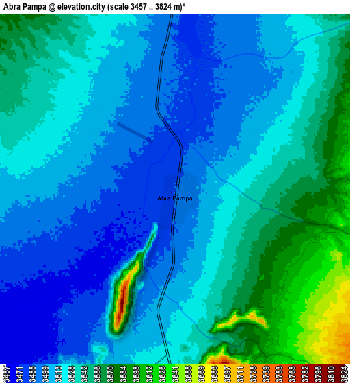
Below is the Elevation map of Abra Pampa, which displays elevation range with different colors. Scale of the first map is from 3465 to 3707 m (11368 to 12162 ft) with average elevation of 3498 meters (=11476 ft) [note 1]
These maps also provides idea of topography and contour of this city, they are displayed at different zoom levels. More info about maps, scale and edge coordinates you can find below images.
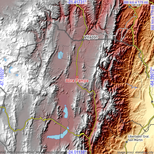
| \ | Map #1 | Map #2 | Topo.Map |
| Scale [m] | 3465..3707 m | 3457..3824 m | × |
| Scale [ft] | 11368..12162 ft | 11342..12546 ft | × |
| Average | 3498 m = 11476 ft | 3525 m = 11565 ft | × |
| Width | 9.01 km = 5.6 mi | 18.03 km = 11.2 mi | 288.4 km = 179.2 mi |
| Height | 9.01 km = 5.6 mi | 18.03 km = 11.2 mi | 288.4 km = 179.2 mi |
| ↑Max Latitude | -22.679949° | -22.639396° | -21.41731° |
| Latitude at center | -22.72049° | -22.72049° | -22.72049° |
| ↓Min Latitude | -22.761019° | -22.801536° | -24.01138° |
| ← Min Longitude | -65.740915° | -65.784861° | -67.10322° |
| Longitude center | -65.69697° | -65.69697° | -65.69697° |
| →Max Longitude | -65.653025° | -65.609079° | -64.29072° |
Nearby cities:
Cities around Abra Pampa sort by population:
• La Quiaca elevation 3451 m
69.6 km,  8°
8°
• Humahuaca 2970 m
64.5 km,  146°
146°
• Tilcara 3180 m
100.2 km,  162°
162°
• El Aguilar 4040 m
55.1 km,  178°
178°
• Maimará 2397 m
104.7 km, 163°
• Tumbaya 2205 m
128.7 km,  169°
169°
• Valle Grande 1693 m
113.7 km,  137°
137°
• Susques 3605 m
101.9 km,  222°
222°
• Santa Catalina 3801 m
93.7 km,  337°
337°
• Santa Victoria 2378 m
91.5 km,  55°
55°
• Rinconada 3915 m
57.5 km,  302°
302°
• Iruya 2810 m
49.8 km,  99°
99°
Multilingual:
 En español:
Abra Pampa elevación 3487 m.
 En France:
Abra Pampa élévation 3487 m.
 Auf Deutsch:
Abra Pampa höhe über dem Meeresspiegel ist 3487 m.

Sources and notes:
- [note 1] Map square and city borders are not equal. Map elevation data is calculated only from area inside that square.
- [src 1] Elevation data from geonames database provided with same terms of usage.
- [src 2] The elevation map of Abra Pampa is generated using elevation data from NASA's 3 arcsec (90m) resolution SRTM data.
- [src 3] Base (background) map © OpenStreetMap contributors tiles are generated by Geofabrik and OpenTopoMap.
Copyright & License:
This Abra Pampa Elevation Map is licensed under CC BY-SA. You may reuse any part from this page, if you give a proper credit by linking to this URL:
 More info on terms of use page.