Laguna Yema elevation
Laguna Yema (Formosa, Departamento de Bermejo), Argentina elevation is 162 meters and Laguna Yema elevation in feet is 531 ft above sea level [src 1]. Laguna Yema is a seat of a second-order administrative division (feature code) with elevation that is 188 meters (617 ft) smaller than average city elevation in Argentina.
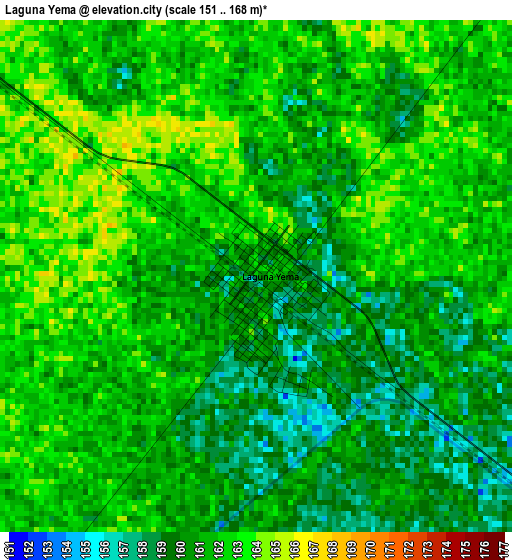
Below is the Elevation map of Laguna Yema, which displays elevation range with different colors. Scale of the first map is from 151 to 168 m (495 to 551 ft) with average elevation of 160.9 meters (=528 ft) [note 1]
These maps also provides idea of topography and contour of this city, they are displayed at different zoom levels. More info about maps, scale and edge coordinates you can find below images.
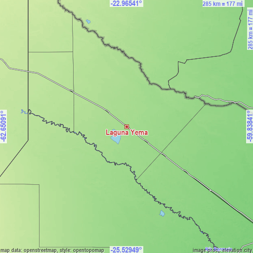
| \ | Map #1 | Topo.Map |
| Scale [m] | 151..168 m | × |
| Scale [ft] | 495..551 ft | × |
| Average | 160.9 m = 528 ft | × |
| Width | 8.91 km = 5.5 mi | 285.1 km = 177.2 mi |
| Height | 8.91 km = 5.5 mi | 285.1 km = 177.2 mi |
| ↑Max Latitude | -24.213837° | -22.96541° |
| Latitude at center | -24.25391° | -24.25391° |
| ↓Min Latitude | -24.29397° | -25.52949° |
| ← Min Longitude | -61.288605° | -62.65091° |
| Longitude center | -61.24466° | -61.24466° |
| →Max Longitude | -61.200715° | -59.83841° |
Nearby cities:
Cities around Laguna Yema sort by population:
• Castelli elevation 113 m
198.5 km,  161°
161°
• Ingeniero Guillermo N. Juárez 185 m
73 km,  302°
302°
• Las Lomitas 134 m
83.2 km,  127°
127°
• Ibarreta 107 m
176.1 km, 127°
• Comandante Fontana 103 m
198.3 km, 127°
• Pampa de los Guanacos 161 m
227.7 km,  195°
195°
• Estanislao del Campo 115 m
146.6 km, 127°
• Villa General Guemes 109 m
186.1 km,  107°
107°
• Pozo del Tigre 127 m
117.4 km, 127°
• General Enrique Mosconi 208 m
157.6 km,  317°
317°
• Monte Quemado 224 m
235.1 km,  222°
222°
• Rivadavia 210 m
166.5 km,  272°
272°
Multilingual:
 En español:
Laguna Yema elevación 162 m.
 En France:
Laguna Yema élévation 162 m.
 Auf Deutsch:
Laguna Yema höhe über dem Meeresspiegel ist 162 m.

Sources and notes:
- [note 1] Map square and city borders are not equal. Map elevation data is calculated only from area inside that square.
- [src 1] Elevation data from geonames database provided with same terms of usage.
- [src 2] The elevation map of Laguna Yema is generated using elevation data from NASA's 3 arcsec (90m) resolution SRTM data.
- [src 3] Base (background) map © OpenStreetMap contributors tiles are generated by Geofabrik and OpenTopoMap.
Copyright & License:
This Laguna Yema Elevation Map is licensed under CC BY-SA. You may reuse any part from this page, if you give a proper credit by linking to this URL:
 More info on terms of use page.