San Jorge elevation
San Jorge (Santa Fe, Departamento de San Martín), Argentina elevation is 109 meters and San Jorge elevation in feet is 358 ft above sea level [src 1]. San Jorge is a populated place (feature code) with elevation that is 241 meters (791 ft) smaller than average city elevation in Argentina.
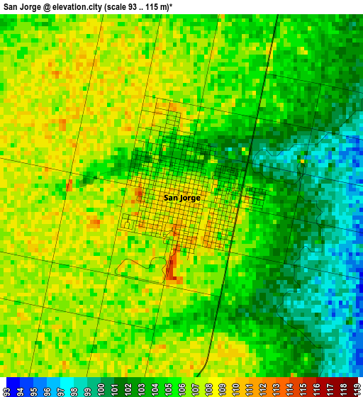
Below is the Elevation map of San Jorge, which displays elevation range with different colors. Scale of the first map is from 93 to 115 m (305 to 377 ft) with average elevation of 104.8 meters (=344 ft) [note 1]
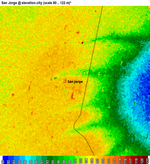
These maps also provides idea of topography and contour of this city, they are displayed at different zoom levels. More info about maps, scale and edge coordinates you can find below images.
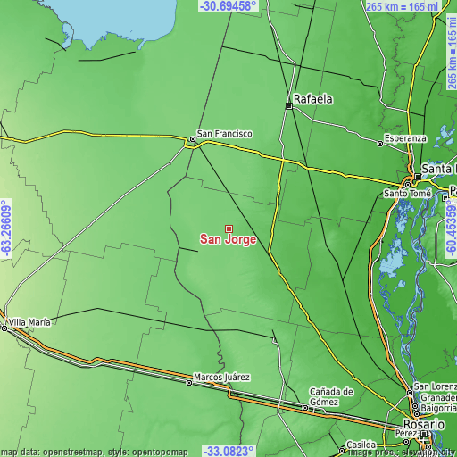
| \ | Map #1 | Map #2 | Topo.Map |
| Scale [m] | 93..115 m | 80..122 m | × |
| Scale [ft] | 305..377 ft | 262..400 ft | × |
| Average | 104.8 m = 344 ft | 102.2 m = 335 ft | × |
| Width | 8.3 km = 5.2 mi | 16.59 km = 10.3 mi | 265.5 km = 165 mi |
| Height | 8.3 km = 5.2 mi | 16.59 km = 10.3 mi | 265.5 km = 165 mi |
| ↑Max Latitude | -31.858863° | -31.82153° | -30.69458° |
| Latitude at center | -31.89618° | -31.89618° | -31.89618° |
| ↓Min Latitude | -31.933482° | -31.970769° | -33.0823° |
| ← Min Longitude | -61.903785° | -61.947731° | -63.26609° |
| Longitude center | -61.85984° | -61.85984° | -61.85984° |
| →Max Longitude | -61.815895° | -61.771949° | -60.45359° |
Nearby cities:
Cities around San Jorge sort by population:
• Rafaela elevation 103 m
80 km,  26°
26°
• San Francisco 118 m
56.2 km,  337°
337°
• Gálvez 57 m
62.1 km,  103°
103°
• Las Rosas 107 m
69.7 km,  157°
157°
• El Trébol 96 m
37 km, 156°
• San Carlos Centro 44 m
74.9 km,  75°
75°
• Devoto 112 m
69.1 km,  322°
322°
• Sastre 109 m
14.6 km,  11°
11°
• Noetinger 113 m
67.3 km,  219°
219°
• Saturnino M. Laspiur 114 m
62.6 km,  290°
290°
• Bella Italia 77 m
80.5 km, 31°
• Las Varas 128 m
72.2 km,  278°
278°
Multilingual:
 En español:
San Jorge elevación 109 m.
 En France:
San Jorge élévation 109 m.
 Auf Deutsch:
San Jorge höhe über dem Meeresspiegel ist 109 m.

Sources and notes:
- [note 1] Map square and city borders are not equal. Map elevation data is calculated only from area inside that square.
- [src 1] Elevation data from geonames database provided with same terms of usage.
- [src 2] The elevation map of San Jorge is generated using elevation data from NASA's 3 arcsec (90m) resolution SRTM data.
- [src 3] Base (background) map © OpenStreetMap contributors tiles are generated by Geofabrik and OpenTopoMap.
Copyright & License:
This San Jorge Elevation Map is licensed under CC BY-SA. You may reuse any part from this page, if you give a proper credit by linking to this URL:
 More info on terms of use page.