Rafaela elevation
Rafaela (Santa Fe, Departamento de Castellanos), Argentina elevation is 103 meters and Rafaela elevation in feet is 338 ft above sea level [src 1]. Rafaela is a seat of a second-order administrative division (feature code) with elevation that is 247 meters (810 ft) smaller than average city elevation in Argentina.
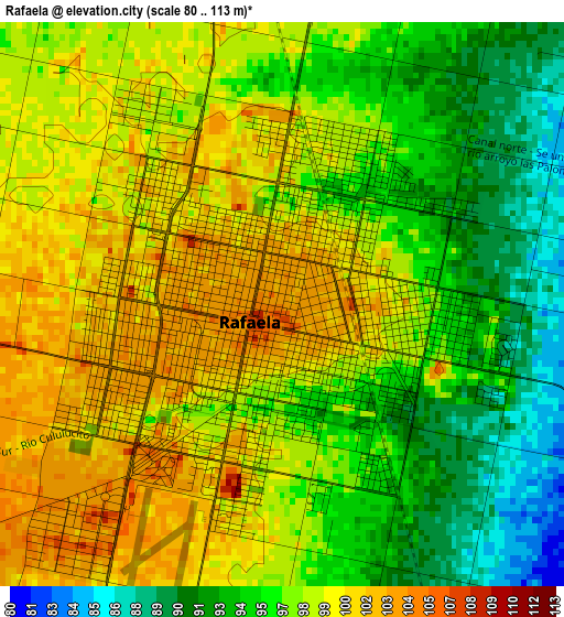
Below is the Elevation map of Rafaela, which displays elevation range with different colors. Scale of the first map is from 80 to 113 m (262 to 371 ft) with average elevation of 97.2 meters (=319 ft) [note 1]
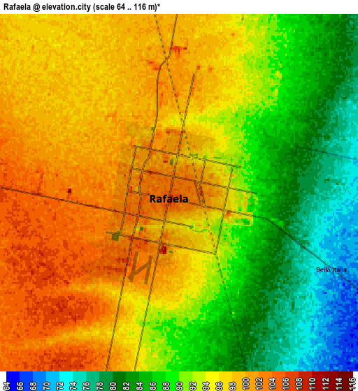
These maps also provides idea of topography and contour of this city, they are displayed at different zoom levels. More info about maps, scale and edge coordinates you can find below images.
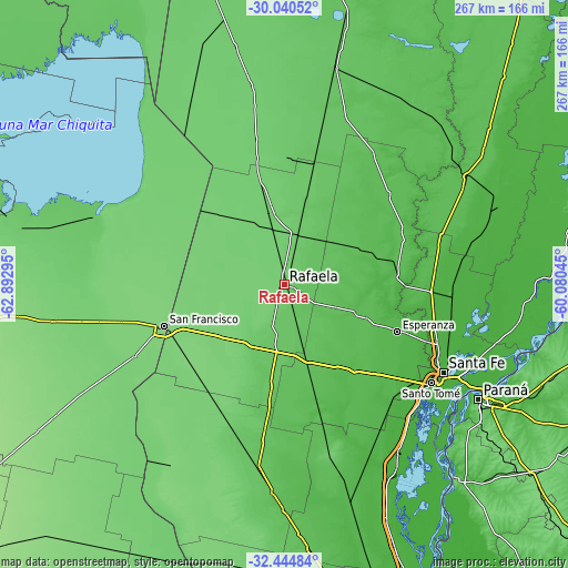
| \ | Map #1 | Map #2 | Topo.Map |
| Scale [m] | 80..113 m | 64..116 m | × |
| Scale [ft] | 262..371 ft | 210..381 ft | × |
| Average | 97.2 m = 319 ft | 92.7 m = 304 ft | × |
| Width | 8.35 km = 5.2 mi | 16.71 km = 10.4 mi | 267.3 km = 166.1 mi |
| Height | 8.35 km = 5.2 mi | 16.71 km = 10.4 mi | 267.3 km = 166.1 mi |
| ↑Max Latitude | -31.212753° | -31.175162° | -30.04052° |
| Latitude at center | -31.25033° | -31.25033° | -31.25033° |
| ↓Min Latitude | -31.287892° | -31.325439° | -32.44484° |
| ← Min Longitude | -61.530645° | -61.574591° | -62.89295° |
| Longitude center | -61.4867° | -61.4867° | -61.4867° |
| →Max Longitude | -61.442755° | -61.398809° | -60.08045° |
Nearby cities:
Cities around Rafaela sort by population:
• San Francisco elevation 118 m
59.9 km,  250°
250°
• Esperanza 40 m
57.1 km,  112°
112°
• Sunchales 98 m
34.8 km,  348°
348°
• Morteros 99 m
77.3 km,  320°
320°
• Recreo 23 m
76.4 km, 110°
• Laguna Paiva 24 m
78.9 km,  94°
94°
• San Carlos Centro 44 m
65 km,  144°
144°
• Brinkmann 105 m
67.7 km,  309°
309°
• Devoto 112 m
79.7 km,  257°
257°
• Sastre 109 m
66 km,  209°
209°
• Porteña 105 m
61.1 km,  295°
295°
• Bella Italia 77 m
8 km,  115°
115°
Multilingual:
 En español:
Rafaela elevación 103 m.
 En France:
Rafaela élévation 103 m.


Sources and notes:
- [note 1] Map square and city borders are not equal. Map elevation data is calculated only from area inside that square.
- [src 1] Elevation data from geonames database provided with same terms of usage.
- [src 2] The elevation map of Rafaela is generated using elevation data from NASA's 3 arcsec (90m) resolution SRTM data.
- [src 3] Base (background) map © OpenStreetMap contributors tiles are generated by Geofabrik and OpenTopoMap.
Copyright & License:
This Rafaela Elevation Map is licensed under CC BY-SA. You may reuse any part from this page, if you give a proper credit by linking to this URL:
 More info on terms of use page.