San José de Feliciano elevation
San José de Feliciano (Entre Rios, Departamento de Feliciano), Argentina elevation is 68 meters and San José de Feliciano elevation in feet is 223 ft above sea level [src 1]. San José de Feliciano is a seat of a second-order administrative division (feature code) with elevation that is 282 meters (925 ft) smaller than average city elevation in Argentina.
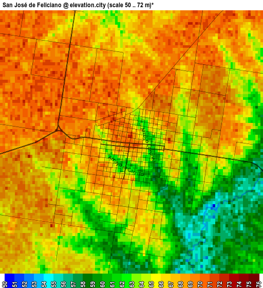
Below is the Elevation map of San José de Feliciano, which displays elevation range with different colors. Scale of the first map is from 50 to 72 m (164 to 236 ft) with average elevation of 65.4 meters (=215 ft) [note 1]
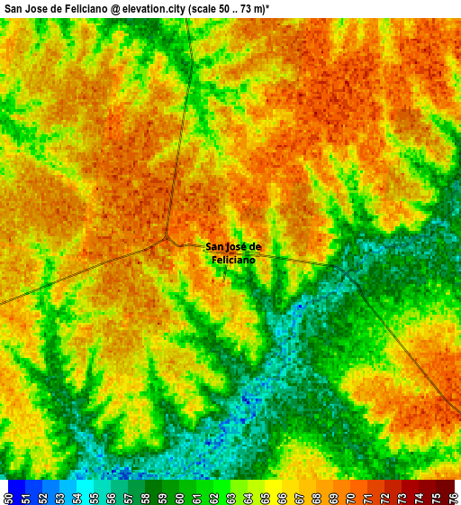
These maps also provides idea of topography and contour of this city, they are displayed at different zoom levels. More info about maps, scale and edge coordinates you can find below images.
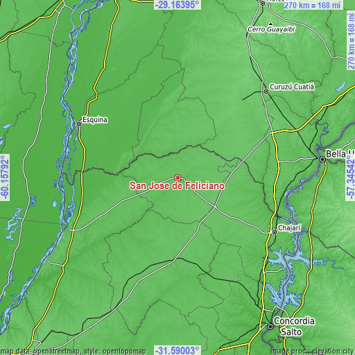
| \ | Map #1 | Map #2 | Topo.Map |
| Scale [m] | 50..72 m | 50..73 m | × |
| Scale [ft] | 164..236 ft | 164..240 ft | × |
| Average | 65.4 m = 215 ft | 64.3 m = 211 ft | × |
| Width | 8.43 km = 5.2 mi | 16.86 km = 10.5 mi | 269.8 km = 167.6 mi |
| Height | 8.43 km = 5.2 mi | 16.86 km = 10.5 mi | 269.8 km = 167.6 mi |
| ↑Max Latitude | -30.346603° | -30.308672° | -29.16395° |
| Latitude at center | -30.38452° | -30.38452° | -30.38452° |
| ↓Min Latitude | -30.422422° | -30.460309° | -31.59003° |
| ← Min Longitude | -58.795615° | -58.839561° | -60.15792° |
| Longitude center | -58.75167° | -58.75167° | -58.75167° |
| →Max Longitude | -58.707725° | -58.663779° | -57.34542° |
Nearby cities:
Cities around San José de Feliciano sort by population:
• Curuzú Cuatiá elevation 79 m
94 km,  45°
45°
• Chajarí 58 m
84.4 km,  118°
118°
• Esquina 39 m
85.3 km,  298°
298°
• Federal 67 m
63.5 km,  182°
182°
• Mocoretá 52 m
79.9 km,  109°
109°
• Pueblo Libertador 38 m
63.9 km,  286°
286°
• Villa del Rosario 69 m
92.4 km, 119°
• Juan Pujol 63 m
86 km,  92°
92°
• Conscripto Bernardi 70 m
80.4 km,  203°
203°
• San Gustavo 56 m
70.6 km,  241°
241°
• Los Conquistadores 75 m
35.6 km,  130°
130°
• Sauce 71 m
33.3 km,  354°
354°
Multilingual:
 En español:
San José de Feliciano elevación 68 m.
 En France:
San José de Feliciano élévation 68 m.
 Auf Deutsch:
San José de Feliciano höhe über dem Meeresspiegel ist 68 m.
 На русском:
San José de Feliciano высота над уровнем моря 68 м
Sources and notes:
- [note 1] Map square and city borders are not equal. Map elevation data is calculated only from area inside that square.
- [src 1] Elevation data from geonames database provided with same terms of usage.
- [src 2] The elevation map of San José de Feliciano is generated using elevation data from NASA's 3 arcsec (90m) resolution SRTM data.
- [src 3] Base (background) map © OpenStreetMap contributors tiles are generated by Geofabrik and OpenTopoMap.
Copyright & License:
This San José de Feliciano Elevation Map is licensed under CC BY-SA. You may reuse any part from this page, if you give a proper credit by linking to this URL:
 More info on terms of use page.