Mocoretá elevation
Mocoretá (Corrientes, Departamento de Monte Caseros), Argentina elevation is 52 meters and Mocoretá elevation in feet is 171 ft above sea level [src 1]. Mocoretá is a populated place (feature code) with elevation that is 298 meters (978 ft) smaller than average city elevation in Argentina.
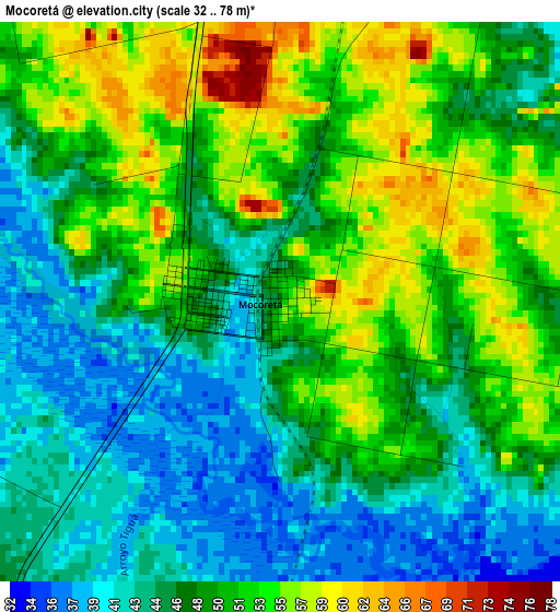
Below is the Elevation map of Mocoretá, which displays elevation range with different colors. Scale of the first map is from 32 to 78 m (105 to 256 ft) with average elevation of 48.6 meters (=159 ft) [note 1]
These maps also provides idea of topography and contour of this city, they are displayed at different zoom levels. More info about maps, scale and edge coordinates you can find below images.
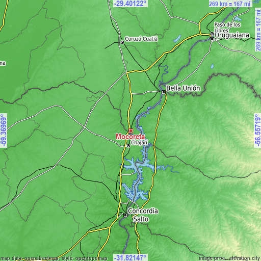
| \ | Map #1 | Map #2 | Topo.Map |
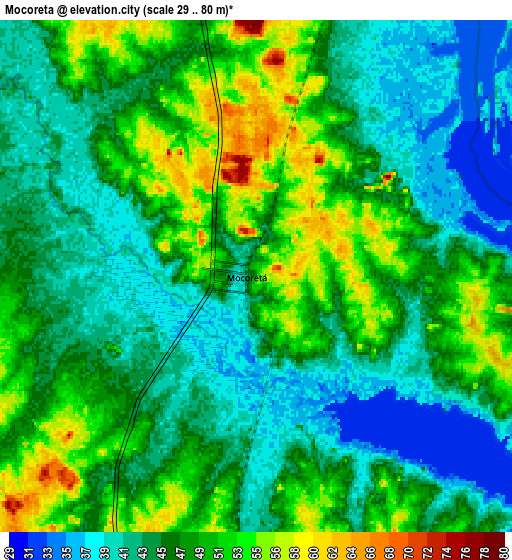
| Scale [m] | 32..78 m | 29..80 m | × |
| Scale [ft] | 105..256 ft | 95..262 ft | × |
| Average | 48.6 m = 159 ft | 46 m = 151 ft | × |
| Width | 8.41 km = 5.2 mi | 16.82 km = 10.5 mi | 269.1 km = 167.2 mi |
| Height | 8.41 km = 5.2 mi | 16.82 km = 10.5 mi | 269.1 km = 167.2 mi |
| ↑Max Latitude | -30.581084° | -30.543244° | -29.40122° |
| Latitude at center | -30.61891° | -30.61891° | -30.61891° |
| ↓Min Latitude | -30.656721° | -30.694517° | -31.82147° |
| ← Min Longitude | -58.007385° | -58.051331° | -59.36969° |
| Longitude center | -57.96344° | -57.96344° | -57.96344° |
| →Max Longitude | -57.919495° | -57.875549° | -56.55719° |
Nearby cities:
Cities around Mocoretá sort by population:
• Concordia elevation 30 m
86.2 km,  183°
183°
• Chajarí 58 m
14.7 km,  186°
186°
• Monte Caseros 53 m
51.3 km,  37°
37°
• Federación 46 m
43.5 km,  171°
171°
• San José de Feliciano 68 m
79.9 km,  289°
289°
• Villa del Rosario 69 m
20.2 km, 166°
• Los Charrúas 72 m
65.5 km,  199°
199°
• Santa Ana 50 m
31.4 km, 174°
• La Criolla 55 m
73.5 km, 190°
• Juan Pujol 63 m
24.5 km,  24°
24°
• Libertad 85 m
65.5 km,  12°
12°
• Los Conquistadores 75 m
48.4 km,  273°
273°
Multilingual:
 En español:
Mocoretá elevación 52 m.
 En France:
Mocoretá élévation 52 m.


Sources and notes:
- [note 1] Map square and city borders are not equal. Map elevation data is calculated only from area inside that square.
- [src 1] Elevation data from geonames database provided with same terms of usage.
- [src 2] The elevation map of Mocoretá is generated using elevation data from NASA's 3 arcsec (90m) resolution SRTM data.
- [src 3] Base (background) map © OpenStreetMap contributors tiles are generated by Geofabrik and OpenTopoMap.
Copyright & License:
This Mocoretá Elevation Map is licensed under CC BY-SA. You may reuse any part from this page, if you give a proper credit by linking to this URL:
 More info on terms of use page.