Federación elevation
Federación (Entre Rios, Departamento de Federación), Argentina elevation is 46 meters and Federación elevation in feet is 151 ft above sea level [src 1]. Federación is a seat of a second-order administrative division (feature code) with elevation that is 304 meters (997 ft) smaller than average city elevation in Argentina.
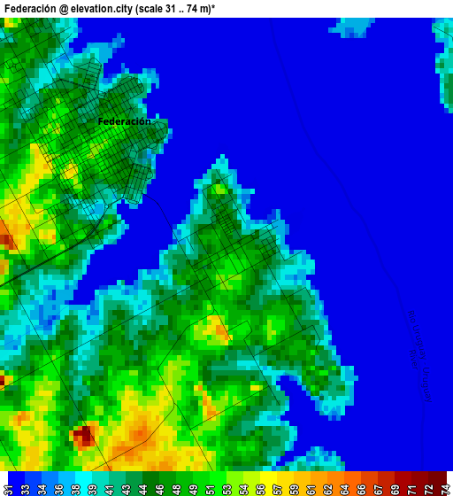
Below is the Elevation map of Federación, which displays elevation range with different colors. Scale of the first map is from 31 to 74 m (102 to 243 ft) with average elevation of 39.7 meters (=130 ft) [note 1]
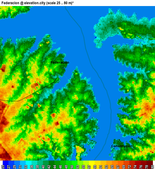
These maps also provides idea of topography and contour of this city, they are displayed at different zoom levels. More info about maps, scale and edge coordinates you can find below images.
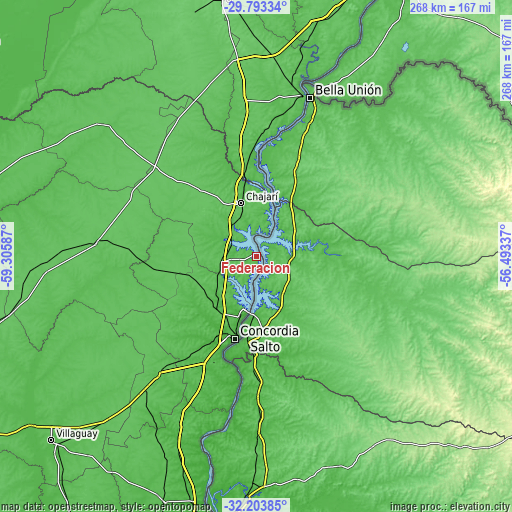
| \ | Map #1 | Map #2 | Topo.Map |
| Scale [m] | 31..74 m | 25..80 m | × |
| Scale [ft] | 102..243 ft | 82..262 ft | × |
| Average | 39.7 m = 130 ft | 42.9 m = 141 ft | × |
| Width | 8.38 km = 5.2 mi | 16.75 km = 10.4 mi | 268 km = 166.5 mi |
| Height | 8.38 km = 5.2 mi | 16.75 km = 10.4 mi | 268 km = 166.5 mi |
| ↑Max Latitude | -30.968537° | -30.930848° | -29.79334° |
| Latitude at center | -31.00621° | -31.00621° | -31.00621° |
| ↓Min Latitude | -31.043869° | -31.081512° | -32.20385° |
| ← Min Longitude | -57.943565° | -57.987511° | -59.30587° |
| Longitude center | -57.89962° | -57.89962° | -57.89962° |
| →Max Longitude | -57.855675° | -57.811729° | -56.49337° |
Nearby cities:
Cities around Federación sort by population:
• Concordia elevation 30 m
44.5 km,  195°
195°
• Chajarí 58 m
29.4 km,  344°
344°
• Federal 67 m
84.4 km,  273°
273°
• Mocoretá 52 m
43.5 km,  351°
351°
• Villa del Rosario 69 m
23.4 km,  356°
356°
• Los Charrúas 72 m
33.3 km,  235°
235°
• General Campos 65 m
74.9 km,  219°
219°
• Santa Ana 50 m
12.2 km, 345°
• La Criolla 55 m
35.2 km,  213°
213°
• Puerto Yeruá 26 m
60 km,  190°
190°
• Juan Pujol 63 m
65.5 km,  3°
3°
• Los Conquistadores 75 m
71.3 km,  310°
310°
Multilingual:
 En español:
Federación elevación 46 m.
 En France:
Federación élévation 46 m.
 Auf Deutsch:
Federación höhe über dem Meeresspiegel ist 46 m.

Sources and notes:
- [note 1] Map square and city borders are not equal. Map elevation data is calculated only from area inside that square.
- [src 1] Elevation data from geonames database provided with same terms of usage.
- [src 2] The elevation map of Federación is generated using elevation data from NASA's 3 arcsec (90m) resolution SRTM data.
- [src 3] Base (background) map © OpenStreetMap contributors tiles are generated by Geofabrik and OpenTopoMap.
Copyright & License:
This Federación Elevation Map is licensed under CC BY-SA. You may reuse any part from this page, if you give a proper credit by linking to this URL:
 More info on terms of use page.