Esquina elevation
Esquina (Corrientes, Departamento de Esquina), Argentina elevation is 39 meters and Esquina elevation in feet is 128 ft above sea level [src 1]. Esquina is a seat of a second-order administrative division (feature code) with elevation that is 311 meters (1020 ft) smaller than average city elevation in Argentina.
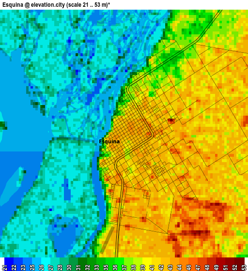
Below is the Elevation map of Esquina, which displays elevation range with different colors. Scale of the first map is from 21 to 53 m (69 to 174 ft) with average elevation of 34.4 meters (=113 ft) [note 1]
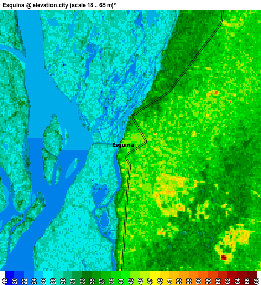
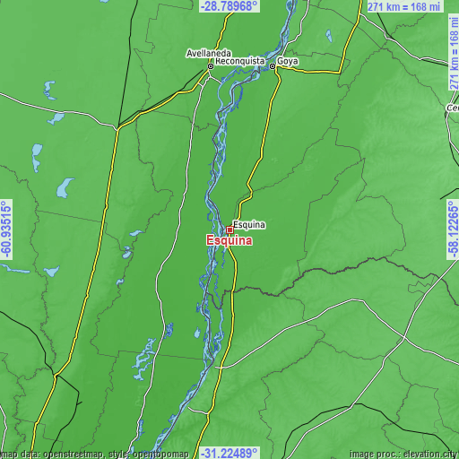
These maps also provides idea of topography and contour of this city, they are displayed at different zoom levels. More info about maps, scale and edge coordinates you can find below images.
| \ | Map #1 | Map #2 | Topo.Map |
| Scale [m] | 21..53 m | 18..68 m | × |
| Scale [ft] | 69..174 ft | 59..223 ft | × |
| Average | 34.4 m = 113 ft | 33.4 m = 110 ft | × |
| Width | 8.46 km = 5.3 mi | 16.92 km = 10.5 mi | 270.8 km = 168.3 mi |
| Height | 8.46 km = 5.3 mi | 16.92 km = 10.5 mi | 270.8 km = 168.3 mi |
| ↑Max Latitude | -29.976701° | -29.938627° | -28.78968° |
| Latitude at center | -30.01476° | -30.01476° | -30.01476° |
| ↓Min Latitude | -30.052805° | -30.090835° | -31.22489° |
| ← Min Longitude | -59.572845° | -59.616791° | -60.93515° |
| Longitude center | -59.5289° | -59.5289° | -59.5289° |
| →Max Longitude | -59.484955° | -59.441009° | -58.12265° |
Nearby cities:
Cities around Esquina sort by population:
• Reconquista elevation 50 m
96.9 km,  353°
353°
• La Paz 53 m
81.6 km,  187°
187°
• Avellaneda 52 m
100.5 km, 352°
• Vera 64 m
90.4 km,  313°
313°
• San Javier 27 m
73.6 km,  211°
211°
• San José de Feliciano 68 m
85.3 km,  118°
118°
• Calchaquí 59 m
74.4 km,  280°
280°
• Malabrigo 59 m
85.6 km,  330°
330°
• Pueblo Libertador 38 m
26.5 km,  149°
149°
• Los Laureles 50 m
74.6 km,  344°
344°
• San Gustavo 56 m
76.1 km,  170°
170°
• Sauce 71 m
71.8 km,  96°
96°
Multilingual:
 En español:
Esquina elevación 39 m.
 En France:
Esquina élévation 39 m.


Sources and notes:
- [note 1] Map square and city borders are not equal. Map elevation data is calculated only from area inside that square.
- [src 1] Elevation data from geonames database provided with same terms of usage.
- [src 2] The elevation map of Esquina is generated using elevation data from NASA's 3 arcsec (90m) resolution SRTM data.
- [src 3] Base (background) map © OpenStreetMap contributors tiles are generated by Geofabrik and OpenTopoMap.
Copyright & License:
This Esquina Elevation Map is licensed under CC BY-SA. You may reuse any part from this page, if you give a proper credit by linking to this URL:
 More info on terms of use page.