San Javier elevation
San Javier (Santa Fe, Departamento de San Javier), Argentina elevation is 27 meters and San Javier elevation in feet is 89 ft above sea level [src 1]. San Javier is a seat of a second-order administrative division (feature code) with elevation that is 323 meters (1060 ft) smaller than average city elevation in Argentina.
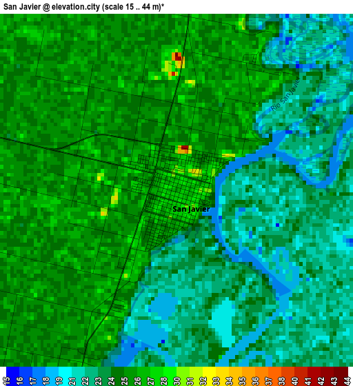
Below is the Elevation map of San Javier, which displays elevation range with different colors. Scale of the first map is from 15 to 44 m (49 to 144 ft) with average elevation of 24.2 meters (=79 ft) [note 1]
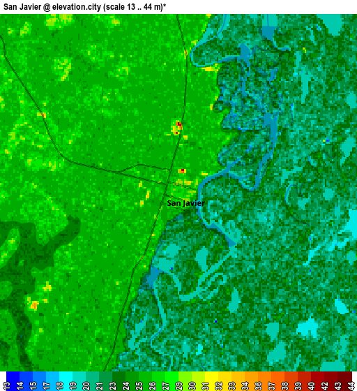
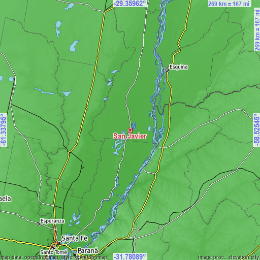
These maps also provides idea of topography and contour of this city, they are displayed at different zoom levels. More info about maps, scale and edge coordinates you can find below images.
| \ | Map #1 | Map #2 | Topo.Map |
| Scale [m] | 15..44 m | 13..44 m | × |
| Scale [ft] | 49..144 ft | 43..144 ft | × |
| Average | 24.2 m = 79 ft | 23.8 m = 78 ft | × |
| Width | 8.41 km = 5.2 mi | 16.83 km = 10.5 mi | 269.2 km = 167.3 mi |
| Height | 8.41 km = 5.2 mi | 16.83 km = 10.5 mi | 269.2 km = 167.3 mi |
| ↑Max Latitude | -30.539968° | -30.502112° | -29.35962° |
| Latitude at center | -30.57781° | -30.57781° | -30.57781° |
| ↓Min Latitude | -30.615637° | -30.653449° | -31.78089° |
| ← Min Longitude | -59.975645° | -60.019591° | -61.33795° |
| Longitude center | -59.9317° | -59.9317° | -59.9317° |
| →Max Longitude | -59.887755° | -59.843809° | -58.52545° |
Nearby cities:
Cities around San Javier sort by population:
• Esquina elevation 39 m
73.6 km,  31°
31°
• La Paz 53 m
32.9 km,  123°
123°
• San Justo 59 m
67.4 km,  249°
249°
• Santa Elena 74 m
43 km,  161°
161°
• Calchaquí 59 m
84 km,  336°
336°
• Bovril 81 m
96.9 km,  151°
151°
• Villa Hernandarias 52 m
72.8 km,  183°
183°
• Pueblo Libertador 38 m
65.4 km,  52°
52°
• Piedras Blancas 46 m
67.6 km, 181°
• Conscripto Bernardi 70 m
96.4 km, 122°
• San Gustavo 56 m
52.5 km,  103°
103°
• Helvecia 26 m
59.8 km,  194°
194°
Multilingual:
 En español:
San Javier elevación 27 m.
 En France:
San Javier élévation 27 m.
 Auf Deutsch:
San Javier höhe über dem Meeresspiegel ist 27 m.

Sources and notes:
- [note 1] Map square and city borders are not equal. Map elevation data is calculated only from area inside that square.
- [src 1] Elevation data from geonames database provided with same terms of usage.
- [src 2] The elevation map of San Javier is generated using elevation data from NASA's 3 arcsec (90m) resolution SRTM data.
- [src 3] Base (background) map © OpenStreetMap contributors tiles are generated by Geofabrik and OpenTopoMap.
Copyright & License:
This San Javier Elevation Map is licensed under CC BY-SA. You may reuse any part from this page, if you give a proper credit by linking to this URL:
 More info on terms of use page.