‘Alī Khēl elevation
‘Alī Khēl (Paktia, Jājī), Afghanistan elevation is 2144 meters and ‘Alī Khēl elevation in feet is 7034 ft above sea level [src 1]. ‘Alī Khēl is a seat of a second-order administrative division (feature code) with elevation that is 725 meters (2379 ft) bigger than average city elevation in Afghanistan.
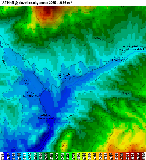
Below is the Elevation map of ‘Alī Khēl, which displays elevation range with different colors. Scale of the first map is from 2065 to 2886 m (6775 to 9469 ft) with average elevation of 2294.6 meters (=7528 ft) [note 1]
These maps also provides idea of topography and contour of this city, they are displayed at different zoom levels. More info about maps, scale and edge coordinates you can find below images.
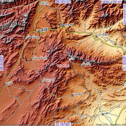
| \ | Map #1 | Topo.Map |
| Scale [m] | 2065..2886 m | × |
| Scale [ft] | 6775..9469 ft | × |
| Average | 2294.6 m = 7528 ft | × |
| Width | 8.11 km = 5 mi | 259.4 km = 161.2 mi |
| Height | 8.11 km = 5 mi | 259.4 km = 161.2 mi |
| ↑Max Latitude | 33.978979° | 35.10112° |
| Latitude at center | 33.94253° | 33.94253° |
| ↓Min Latitude | 33.906065° | 32.76796° |
| ← Min Longitude | 69.675135° | 68.31283° |
| Longitude center | 69.71908° | 69.71908° |
| →Max Longitude | 69.763025° | 71.12533° |
Nearby cities:
Cities around ‘Alī Khēl sort by population:
• Ḩukūmatī Azrah elevation 2330 m
26.6 km,  345°
345°
• Khulbisāt 1148 m
56.4 km,  151°
151°
• Kaz̲h̲ah 1276 m
54.1 km,  52°
52°
• Chakaray 2372 m
51.3 km,  329°
329°
• Salām Khēl 2417 m
47 km,  229°
229°
• Khōshī 2252 m
46.8 km,  277°
277°
• Zorkot 1845 m
44.6 km,  178°
178°
• Wulêswālī Sayyid Karam 2458 m
42.8 km, 229°
• Māmā Khēl 1531 m
42.2 km,  37°
37°
• Maīdān Khūlah 2026 m
33.1 km,  170°
170°
• Tsapêraī 1679 m
22.3 km,  124°
124°
• Tsamkanī 1716 m
17.9 km, 149°
Multilingual:
 En español:
‘Alī Khēl elevación 2144 m.
 En France:
‘Alī Khēl élévation 2144 m.
 Auf Deutsch:
‘Alī Khēl höhe über dem Meeresspiegel ist 2144 m.

Sources and notes:
- [note 1] Map square and city borders are not equal. Map elevation data is calculated only from area inside that square.
- [src 1] Elevation data from geonames database provided with same terms of usage.
- [src 2] The elevation map of ‘Alī Khēl is generated using elevation data from NASA's 3 arcsec (90m) resolution SRTM data.
- [src 3] Base (background) map © OpenStreetMap contributors tiles are generated by Geofabrik and OpenTopoMap.
Copyright & License:
This ‘Alī Khēl Elevation Map is licensed under CC BY-SA. You may reuse any part from this page, if you give a proper credit by linking to this URL:
 More info on terms of use page.