Salām Khēl elevation
Salām Khēl (Paktia, Aḩmadābād), Afghanistan elevation is 2417 meters and Salām Khēl elevation in feet is 7930 ft above sea level [src 1]. Salām Khēl is a seat of a second-order administrative division (feature code) with elevation that is 998 meters (3274 ft) bigger than average city elevation in Afghanistan.
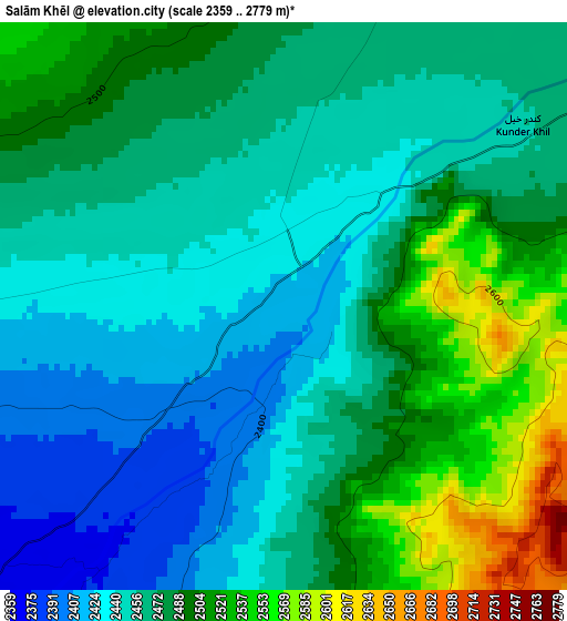
Below is the Elevation map of Salām Khēl, which displays elevation range with different colors. Scale of the first map is from 2359 to 2779 m (7740 to 9117 ft) with average elevation of 2471.8 meters (=8110 ft) [note 1]
These maps also provides idea of topography and contour of this city, they are displayed at different zoom levels. More info about maps, scale and edge coordinates you can find below images.
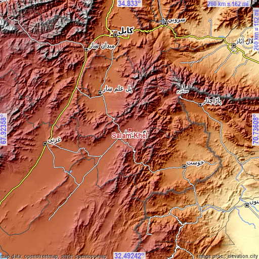
| \ | Map #1 | Topo.Map |
| Scale [m] | 2359..2779 m | × |
| Scale [ft] | 7740..9117 ft | × |
| Average | 2471.8 m = 8110 ft | × |
| Width | 8.13 km = 5.1 mi | 260.2 km = 161.7 mi |
| Height | 8.13 km = 5.1 mi | 260.3 km = 161.7 mi |
| ↑Max Latitude | 33.707235° | 34.833° |
| Latitude at center | 33.67067° | 33.67067° |
| ↓Min Latitude | 33.634089° | 32.49242° |
| ← Min Longitude | 69.285885° | 67.92358° |
| Longitude center | 69.32983° | 69.32983° |
| →Max Longitude | 69.373775° | 70.73608° |
Nearby cities:
Cities around Salām Khēl sort by population:
• Gardez elevation 2308 m
12.6 km,  229°
229°
• Baraki Barak 1940 m
48.2 km,  313°
313°
• Pul-e ‘Alam 1921 m
45.9 km,  321°
321°
• Tsamkanī 1716 m
47.4 km,  71°
71°
• ‘Alī Khēl 2144 m
47 km,  49°
49°
• Maīdān Khūlah 2026 m
41.8 km,  93°
93°
• Zorkot 1845 m
40.1 km,  110°
110°
• Charkh 2081 m
38.9 km,  291°
291°
• Zurmat 2150 m
38.1 km, 227°
• Khōshī 2252 m
38 km,  343°
343°
• Shwāk 2300 m
27.8 km,  170°
170°
• Wulêswālī Sayyid Karam 2458 m
4.2 km,  58°
58°
Multilingual:
 En español:
Salām Khēl elevación 2417 m.
 En France:
Salām Khēl élévation 2417 m.
 Auf Deutsch:
Salām Khēl höhe über dem Meeresspiegel ist 2417 m.

Sources and notes:
- [note 1] Map square and city borders are not equal. Map elevation data is calculated only from area inside that square.
- [src 1] Elevation data from geonames database provided with same terms of usage.
- [src 2] The elevation map of Salām Khēl is generated using elevation data from NASA's 3 arcsec (90m) resolution SRTM data.
- [src 3] Base (background) map © OpenStreetMap contributors tiles are generated by Geofabrik and OpenTopoMap.
Copyright & License:
This Salām Khēl Elevation Map is licensed under CC BY-SA. You may reuse any part from this page, if you give a proper credit by linking to this URL:
 More info on terms of use page.