Charkh elevation
Charkh (Logar), Afghanistan elevation is 2081 meters and Charkh elevation in feet is 6827 ft above sea level [src 1]. Charkh is a seat of a second-order administrative division (feature code) with elevation that is 662 meters (2172 ft) bigger than average city elevation in Afghanistan.
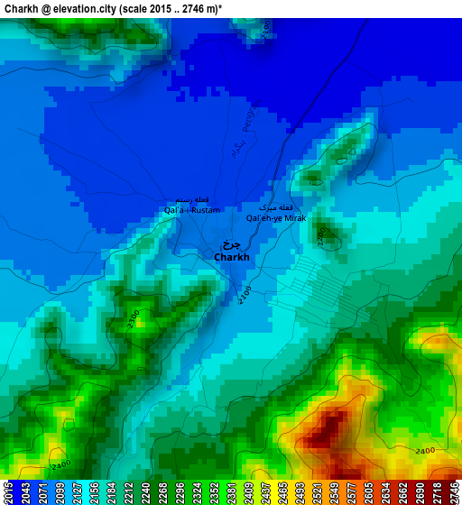
Below is the Elevation map of Charkh, which displays elevation range with different colors. Scale of the first map is from 2015 to 2746 m (6611 to 9009 ft) with average elevation of 2167.7 meters (=7112 ft) [note 1]
These maps also provides idea of topography and contour of this city, they are displayed at different zoom levels. More info about maps, scale and edge coordinates you can find below images.
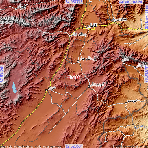
| \ | Map #1 | Topo.Map |
| Scale [m] | 2015..2746 m | × |
| Scale [ft] | 6611..9009 ft | × |
| Average | 2167.7 m = 7112 ft | × |
| Width | 8.12 km = 5 mi | 259.9 km = 161.5 mi |
| Height | 8.12 km = 5 mi | 259.9 km = 161.5 mi |
| ↑Max Latitude | 33.833631° | 34.95771° |
| Latitude at center | 33.79712° | 33.79712° |
| ↓Min Latitude | 33.760593° | 32.62058° |
| ← Min Longitude | 68.893545° | 67.53124° |
| Longitude center | 68.93749° | 68.93749° |
| →Max Longitude | 68.981435° | 70.34374° |
Nearby cities:
Cities around Charkh sort by population:
• Gardez elevation 2308 m
34.7 km,  129°
129°
• Baraki Barak 1940 m
19 km,  3°
3°
• Pul-e ‘Alam 1921 m
23.4 km,  19°
19°
• Tōrmay 2296 m
51 km,  256°
256°
• Kalān Deh 2502 m
49.6 km,  275°
275°
• Muḩammad Āghah Wuluswālī 1853 m
48.7 km, 17°
• Rāmak 2183 m
42 km,  223°
223°
• Wulêswālī Sayyid Karam 2458 m
41.6 km,  106°
106°
• Zurmat 2150 m
40.8 km,  168°
168°
• Salām Khēl 2417 m
38.9 km, 111°
• Khōshī 2252 m
34.1 km,  48°
48°
• Markaz-e Sayyidābād 2113 m
30.6 km,  317°
317°
Multilingual:
 En español:
Charkh elevación 2081 m.
 En France:
Charkh élévation 2081 m.


Sources and notes:
- [note 1] Map square and city borders are not equal. Map elevation data is calculated only from area inside that square.
- [src 1] Elevation data from geonames database provided with same terms of usage.
- [src 2] The elevation map of Charkh is generated using elevation data from NASA's 3 arcsec (90m) resolution SRTM data.
- [src 3] Base (background) map © OpenStreetMap contributors tiles are generated by Geofabrik and OpenTopoMap.
Copyright & License:
This Charkh Elevation Map is licensed under CC BY-SA. You may reuse any part from this page, if you give a proper credit by linking to this URL:
 More info on terms of use page.