Ḩukūmatī Azrah elevation
Ḩukūmatī Azrah (Logar, Azrah), Afghanistan elevation is 2330 meters and Ḩukūmatī Azrah elevation in feet is 7644 ft above sea level [src 1]. Ḩukūmatī Azrah is a seat of a second-order administrative division (feature code) with elevation that is 911 meters (2989 ft) bigger than average city elevation in Afghanistan.
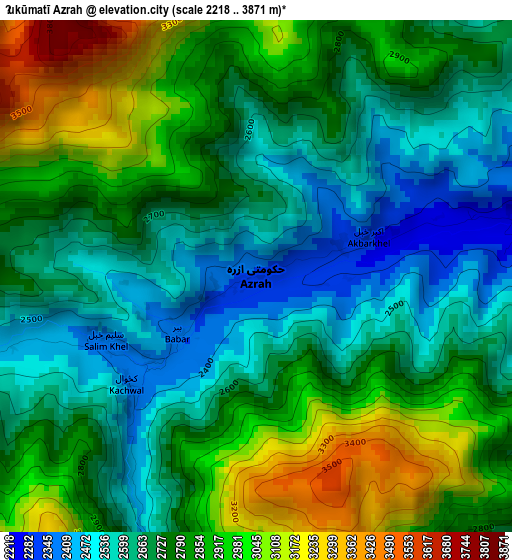
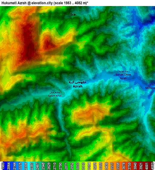
Below is the Elevation map of Ḩukūmatī Azrah, which displays elevation range with different colors. Scale of the first map is from 2218 to 3871 m (7277 to 12700 ft) with average elevation of 2768.1 meters (=9082 ft) [note 1]
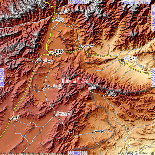
These maps also provides idea of topography and contour of this city, they are displayed at different zoom levels. More info about maps, scale and edge coordinates you can find below images.
| \ | Map #1 | Map #2 | Topo.Map |
| Scale [m] | 2218..3871 m | 1983..4082 m | × |
| Scale [ft] | 7277..12700 ft | 6506..13392 ft | × |
| Average | 2768.1 m = 9082 ft | 2842.6 m = 9326 ft | × |
| Width | 8.09 km = 5 mi | 16.17 km = 10 mi | 258.7 km = 160.7 mi |
| Height | 8.09 km = 5 mi | 16.17 km = 10 mi | 258.7 km = 160.7 mi |
| ↑Max Latitude | 34.2099° | 34.246234° | 35.32894° |
| Latitude at center | 34.17355° | 34.17355° | 34.17355° |
| ↓Min Latitude | 34.137184° | 34.100803° | 33.00213° |
| ← Min Longitude | 69.601785° | 69.557839° | 68.23948° |
| Longitude center | 69.64573° | 69.64573° | 69.64573° |
| →Max Longitude | 69.689675° | 69.733621° | 71.05198° |
Nearby cities:
Cities around Ḩukūmatī Azrah sort by population:
• Pachīr wa Āgām elevation 1241 m
58.2 km,  87°
87°
• Qal‘ah-ye Na‘īm 1819 m
50.6 km,  299°
299°
• Muḩammad Āghah Wuluswālī 1853 m
50.4 km,  275°
275°
• Kaz̲h̲ah 1276 m
49.9 km,  81°
81°
• Bagrāmī 1788 m
49.3 km,  316°
316°
• Sarōbī 987 m
47.4 km,  12°
12°
• Tsapêraī 1679 m
45.8 km,  146°
146°
• Khōshī 2252 m
44.1 km,  243°
243°
• Tsamkanī 1716 m
44.1 km,  159°
159°
• Māmā Khēl 1531 m
33.2 km, 76°
• Chakaray 2372 m
26.7 km,  314°
314°
• ‘Alī Khēl 2144 m
26.6 km,  165°
165°
Multilingual:
 En español:
Ḩukūmatī Azrah elevación 2330 m.
 En France:
Ḩukūmatī Azrah élévation 2330 m.
 Auf Deutsch:
Ḩukūmatī Azrah höhe über dem Meeresspiegel ist 2330 m.

Sources and notes:
- [note 1] Map square and city borders are not equal. Map elevation data is calculated only from area inside that square.
- [src 1] Elevation data from geonames database provided with same terms of usage.
- [src 2] The elevation map of Ḩukūmatī Azrah is generated using elevation data from NASA's 3 arcsec (90m) resolution SRTM data.
- [src 3] Base (background) map © OpenStreetMap contributors tiles are generated by Geofabrik and OpenTopoMap.
Copyright & License:
This Ḩukūmatī Azrah Elevation Map is licensed under CC BY-SA. You may reuse any part from this page, if you give a proper credit by linking to this URL:
 More info on terms of use page.