Sarōbī elevation
Sarōbī (Kabul, Surobi), Afghanistan elevation is 987 meters and Sarōbī elevation in feet is 3238 ft above sea level [src 1]. Sarōbī is a seat of a second-order administrative division (feature code) with elevation that is 432 meters (1417 ft) smaller than average city elevation in Afghanistan.
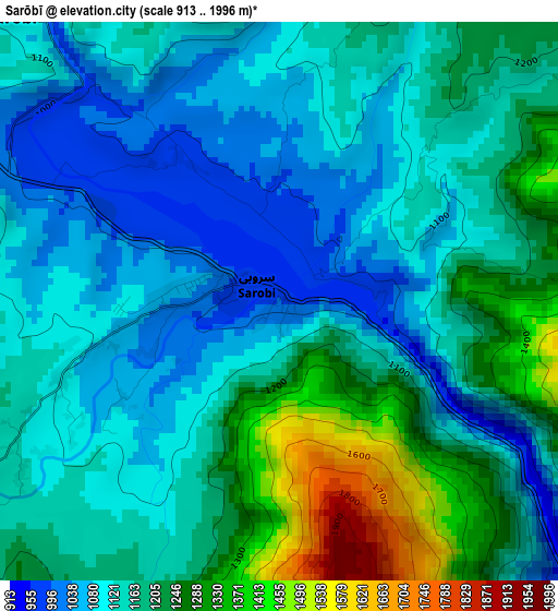
Below is the Elevation map of Sarōbī, which displays elevation range with different colors. Scale of the first map is from 913 to 1996 m (2995 to 6549 ft) with average elevation of 1164.6 meters (=3821 ft) [note 1]
These maps also provides idea of topography and contour of this city, they are displayed at different zoom levels. More info about maps, scale and edge coordinates you can find below images.
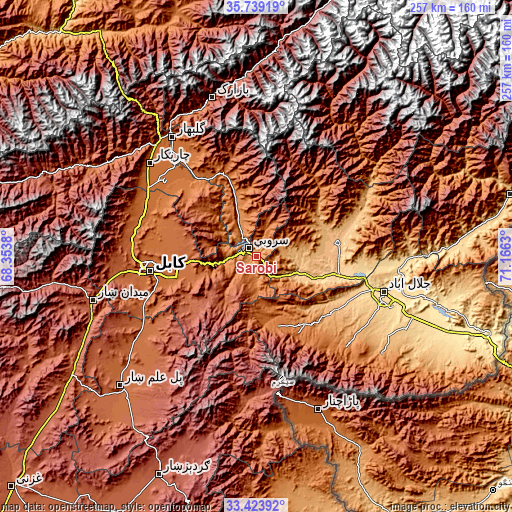
| \ | Map #1 | Topo.Map |
| Scale [m] | 913..1996 m | × |
| Scale [ft] | 2995..6549 ft | × |
| Average | 1164.6 m = 3821 ft | × |
| Width | 8.05 km = 5 mi | 257.4 km = 159.9 mi |
| Height | 8.05 km = 5 mi | 257.4 km = 159.9 mi |
| ↑Max Latitude | 34.62579° | 35.73919° |
| Latitude at center | 34.58962° | 34.58962° |
| ↓Min Latitude | 34.553435° | 33.42392° |
| ← Min Longitude | 69.716105° | 68.3538° |
| Longitude center | 69.76005° | 69.76005° |
| →Max Longitude | 69.803995° | 71.1663° |
Nearby cities:
Cities around Sarōbī sort by population:
• Mehtar Lām elevation 795 m
42.1 km,  77°
77°
• Ḩukūmatī Azrah 2330 m
47.4 km,  192°
192°
• Tagāb 1335 m
31.2 km,  341°
341°
• Shērwānī-ye Bālā 1786 m
49.5 km, 342°
• Dowlat Shāh 1551 m
49.2 km,  35°
35°
• Pul-e Sangī 1776 m
45.8 km,  271°
271°
• Bagrāmī 1788 m
45.8 km,  256°
256°
• Qarghah’ī 659 m
44.4 km,  95°
95°
• Māmā Khēl 1531 m
44 km,  150°
150°
• Chakaray 2372 m
40.5 km,  226°
226°
• Ḏanḏar 1724 m
34.4 km,  310°
310°
• Alah Sāy 1602 m
34.3 km,  353°
353°
Multilingual:
 En español:
Sarōbī elevación 987 m.
 En France:
Sarōbī élévation 987 m.


Sources and notes:
- [note 1] Map square and city borders are not equal. Map elevation data is calculated only from area inside that square.
- [src 1] Elevation data from geonames database provided with same terms of usage.
- [src 2] The elevation map of Sarōbī is generated using elevation data from NASA's 3 arcsec (90m) resolution SRTM data.
- [src 3] Base (background) map © OpenStreetMap contributors tiles are generated by Geofabrik and OpenTopoMap.
Copyright & License:
This Sarōbī Elevation Map is licensed under CC BY-SA. You may reuse any part from this page, if you give a proper credit by linking to this URL:
 More info on terms of use page.