Tagāb elevation
Tagāb (Kapisa), Afghanistan elevation is 1335 meters and Tagāb elevation in feet is 4380 ft above sea level [src 1]. Tagāb is a populated place (feature code) with elevation that is 84 meters (276 ft) smaller than average city elevation in Afghanistan.
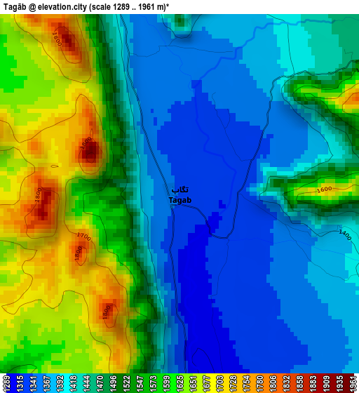
Below is the Elevation map of Tagāb, which displays elevation range with different colors. Scale of the first map is from 1289 to 1961 m (4229 to 6434 ft) with average elevation of 1486.2 meters (=4876 ft) [note 1]
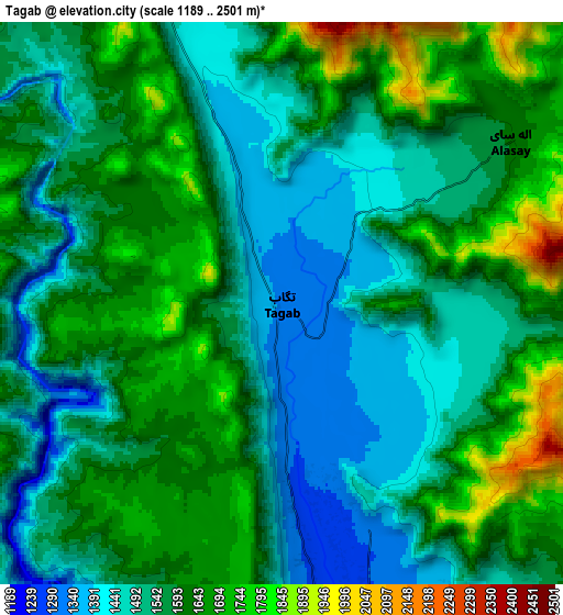
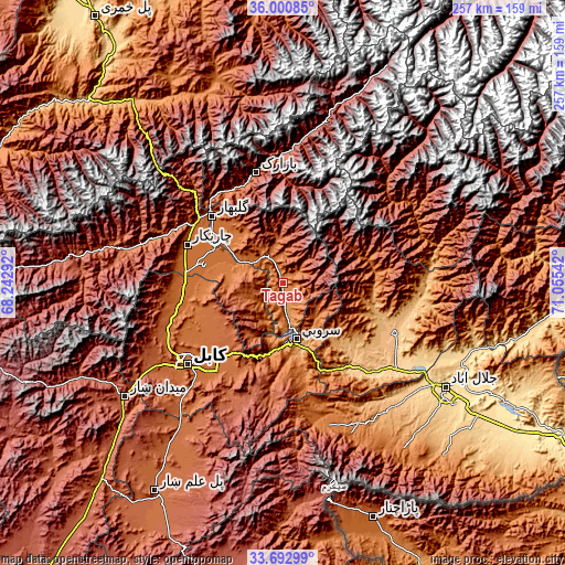
These maps also provides idea of topography and contour of this city, they are displayed at different zoom levels. More info about maps, scale and edge coordinates you can find below images.
| \ | Map #1 | Map #2 | Topo.Map |
| Scale [m] | 1289..1961 m | 1189..2501 m | × |
| Scale [ft] | 4229..6434 ft | 3901..8205 ft | × |
| Average | 1486.2 m = 4876 ft | 1572.8 m = 5160 ft | × |
| Width | 8.02 km = 5 mi | 16.04 km = 10 mi | 256.6 km = 159.4 mi |
| Height | 8.02 km = 5 mi | 16.04 km = 10 mi | 256.6 km = 159.4 mi |
| ↑Max Latitude | 34.891064° | 34.927102° | 36.00085° |
| Latitude at center | 34.85501° | 34.85501° | 34.85501° |
| ↓Min Latitude | 34.818941° | 34.782855° | 33.69299° |
| ← Min Longitude | 69.605225° | 69.561279° | 68.24292° |
| Longitude center | 69.64917° | 69.64917° | 69.64917° |
| →Max Longitude | 69.693115° | 69.737061° | 71.05542° |
Nearby cities:
Cities around Tagāb sort by population:
• Sidqābād elevation 1486 m
33 km,  304°
304°
• Kalakān 1593 m
46.2 km,  260°
260°
• Pul-e Sangī 1776 m
45.5 km,  231°
231°
• Qarah Bāgh Bāzār 1531 m
43.7 km,  269°
269°
• Ibrāhīm Khān 1491 m
42 km, 301°
• Dowlat Shāh 1551 m
39.9 km,  74°
74°
• Ghulām ‘Alī 1489 m
39.8 km,  285°
285°
• Ḩājī Khēl 1914 m
34.4 km,  325°
325°
• Sarōbī 987 m
31.2 km,  161°
161°
• Shērwānī-ye Bālā 1786 m
18.3 km,  345°
345°
• Ḏanḏar 1724 m
17.4 km,  245°
245°
• Alah Sāy 1602 m
8 km,  54°
54°
Multilingual:
 En español:
Tagāb elevación 1335 m.
 En France:
Tagāb élévation 1335 m.


Sources and notes:
- [note 1] Map square and city borders are not equal. Map elevation data is calculated only from area inside that square.
- [src 1] Elevation data from geonames database provided with same terms of usage.
- [src 2] The elevation map of Tagāb is generated using elevation data from NASA's 3 arcsec (90m) resolution SRTM data.
- [src 3] Base (background) map © OpenStreetMap contributors tiles are generated by Geofabrik and OpenTopoMap.
Copyright & License:
This Tagāb Elevation Map is licensed under CC BY-SA. You may reuse any part from this page, if you give a proper credit by linking to this URL:
 More info on terms of use page.