Mehtar Lām elevation
Mehtar Lām (Laghman), Afghanistan elevation is 795 meters and Mehtar Lām elevation in feet is 2608 ft above sea level [src 1]. Mehtar Lām is a seat of a first-order administrative division (feature code) with elevation that is 624 meters (2047 ft) smaller than average city elevation in Afghanistan.
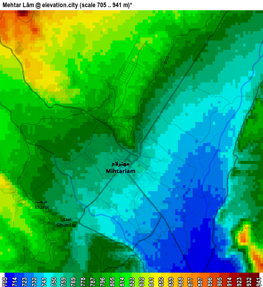
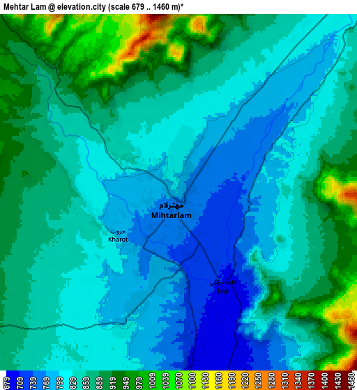
Below is the Elevation map of Mehtar Lām, which displays elevation range with different colors. Scale of the first map is from 705 to 941 m (2313 to 3087 ft) with average elevation of 780.9 meters (=2562 ft) [note 1]
These maps also provides idea of topography and contour of this city, they are displayed at different zoom levels. More info about maps, scale and edge coordinates you can find below images.
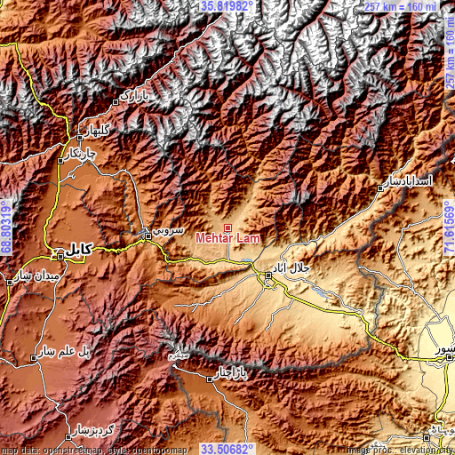
| \ | Map #1 | Map #2 | Topo.Map |
| Scale [m] | 705..941 m | 679..1460 m | × |
| Scale [ft] | 2313..3087 ft | 2228..4790 ft | × |
| Average | 780.9 m = 2562 ft | 851.6 m = 2794 ft | × |
| Width | 8.04 km = 5 mi | 16.07 km = 10 mi | 257.2 km = 159.8 mi |
| Height | 8.04 km = 5 mi | 16.07 km = 10 mi | 257.2 km = 159.8 mi |
| ↑Max Latitude | 34.707524° | 34.743642° | 35.81982° |
| Latitude at center | 34.67139° | 34.67139° | 34.67139° |
| ↓Min Latitude | 34.63524° | 34.599075° | 33.50682° |
| ← Min Longitude | 70.165495° | 70.121549° | 68.80319° |
| Longitude center | 70.20944° | 70.20944° | 70.20944° |
| →Max Longitude | 70.253385° | 70.297331° | 71.61569° |
Nearby cities:
Cities around Mehtar Lām sort by population:
• Jalālābād elevation 575 m
35.1 km,  140°
140°
• Nūrgal 679 m
51.2 km,  97°
97°
• Sangar Sarāy 517 m
49.1 km,  126°
126°
• Kaz̲h̲ah 1276 m
47.9 km,  182°
182°
• Khafizan 909 m
45.3 km,  160°
160°
• Sarōbī 987 m
42.1 km,  257°
257°
• Sheywah 602 m
36.4 km,  107°
107°
• Qal‘ah-ye Shāhī 894 m
35 km,  94°
94°
• Dowlat Shāh 1551 m
33.5 km,  337°
337°
• Sulţānpūr-e ‘Ulyā 696 m
29.9 km, 164°
• Wuluswālī ‘Alīngār 937 m
22.8 km,  36°
36°
• Qarghah’ī 659 m
13.4 km,  166°
166°
Multilingual:
 En español:
Mehtar Lām elevación 795 m.
 En France:
Mehtar Lām élévation 795 m.
 Auf Deutsch:
Mehtar Lām höhe über dem Meeresspiegel ist 795 m.

Sources and notes:
- [note 1] Map square and city borders are not equal. Map elevation data is calculated only from area inside that square.
- [src 1] Elevation data from geonames database provided with same terms of usage.
- [src 2] The elevation map of Mehtar Lām is generated using elevation data from NASA's 3 arcsec (90m) resolution SRTM data.
- [src 3] Base (background) map © OpenStreetMap contributors tiles are generated by Geofabrik and OpenTopoMap.
Copyright & License:
This Mehtar Lām Elevation Map is licensed under CC BY-SA. You may reuse any part from this page, if you give a proper credit by linking to this URL:
 More info on terms of use page.