Khulbisāt elevation
Khulbisāt (Khowst, Şabarī), Afghanistan elevation is 1148 meters and Khulbisāt elevation in feet is 3766 ft above sea level [src 1]. Khulbisāt is a seat of a second-order administrative division (feature code) with elevation that is 271 meters (889 ft) smaller than average city elevation in Afghanistan.
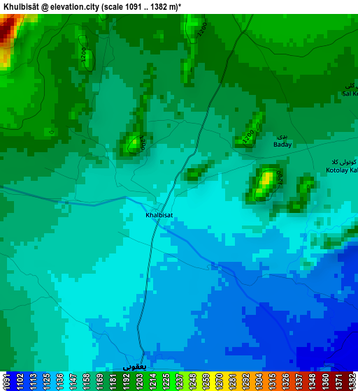
Below is the Elevation map of Khulbisāt, which displays elevation range with different colors. Scale of the first map is from 1091 to 1382 m (3579 to 4534 ft) with average elevation of 1159.5 meters (=3804 ft) [note 1]
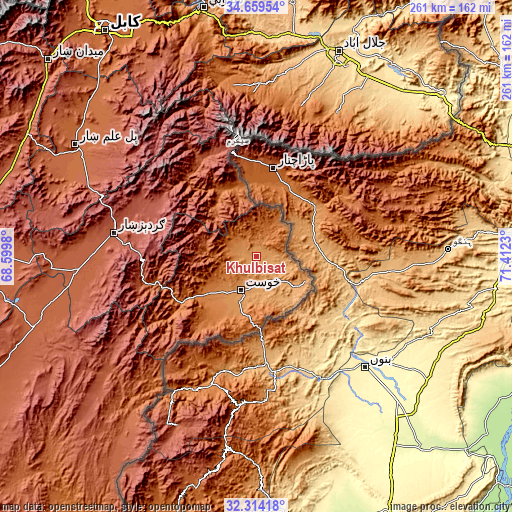
These maps also provides idea of topography and contour of this city, they are displayed at different zoom levels. More info about maps, scale and edge coordinates you can find below images.
| \ | Map #1 | Topo.Map |
| Scale [m] | 1091..1382 m | × |
| Scale [ft] | 3579..4534 ft | × |
| Average | 1159.5 m = 3804 ft | × |
| Width | 8.15 km = 5.1 mi | 260.8 km = 162.1 mi |
| Height | 8.15 km = 5.1 mi | 260.8 km = 162.1 mi |
| ↑Max Latitude | 33.53144° | 34.65954° |
| Latitude at center | 33.4948° | 33.4948° |
| ↓Min Latitude | 33.458145° | 32.31418° |
| ← Min Longitude | 69.962105° | 68.5998° |
| Longitude center | 70.00605° | 70.00605° |
| →Max Longitude | 70.049995° | 71.4123° |
Nearby cities:
Cities around Khulbisāt sort by population:
• Khōst elevation 1183 m
19 km,  204°
204°
• Wulêswālī Sayyid Karam 2458 m
62.9 km,  290°
290°
• Shwāk 2300 m
58.9 km,  262°
262°
• ‘Alī Khēl 2144 m
56.4 km,  331°
331°
• Spērah 1743 m
56 km,  234°
234°
• Dwah Manḏay 1543 m
45.7 km,  238°
238°
• Tsamkanī 1716 m
38.5 km, 332°
• Tsapêraī 1679 m
38.1 km,  347°
347°
• Maīdān Khūlah 2026 m
27 km,  309°
309°
• Zorkot 1845 m
25.7 km,  281°
281°
• Shaykh Amīr Kêlay 1207 m
24.6 km, 200°
• ‘Alī Shēr ‘Alāqahdārī 1082 m
8.6 km,  139°
139°
Multilingual:
 En español:
Khulbisāt elevación 1148 m.
 En France:
Khulbisāt élévation 1148 m.
 Auf Deutsch:
Khulbisāt höhe über dem Meeresspiegel ist 1148 m.

Sources and notes:
- [note 1] Map square and city borders are not equal. Map elevation data is calculated only from area inside that square.
- [src 1] Elevation data from geonames database provided with same terms of usage.
- [src 2] The elevation map of Khulbisāt is generated using elevation data from NASA's 3 arcsec (90m) resolution SRTM data.
- [src 3] Base (background) map © OpenStreetMap contributors tiles are generated by Geofabrik and OpenTopoMap.
Copyright & License:
This Khulbisāt Elevation Map is licensed under CC BY-SA. You may reuse any part from this page, if you give a proper credit by linking to this URL:
 More info on terms of use page.