Markaz-e Ḩukūmat-e Darwēshān elevation
Markaz-e Ḩukūmat-e Darwēshān (Helmand, Garmsīr), Afghanistan elevation is 714 meters and Markaz-e Ḩukūmat-e Darwēshān elevation in feet is 2343 ft above sea level [src 1]. Markaz-e Ḩukūmat-e Darwēshān is a populated place (feature code) with elevation that is 705 meters (2313 ft) smaller than average city elevation in Afghanistan.
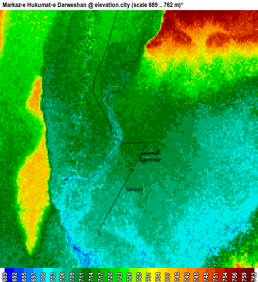
Below is the Elevation map of Markaz-e Ḩukūmat-e Darwēshān, which displays elevation range with different colors. Scale of the first map is from 689 to 728 m (2260 to 2388 ft) with average elevation of 711.4 meters (=2334 ft) [note 1]
These maps also provides idea of topography and contour of this city, they are displayed at different zoom levels. More info about maps, scale and edge coordinates you can find below images.

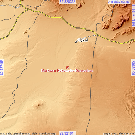
| \ | Map #1 | Map #2 | Topo.Map |
| Scale [m] | 689..728 m | 689..762 m | × |
| Scale [ft] | 2260..2388 ft | 2260..2500 ft | × |
| Average | 711.4 m = 2334 ft | 715.3 m = 2347 ft | × |
| Width | 8.36 km = 5.2 mi | 16.73 km = 10.4 mi | 267.7 km = 166.3 mi |
| Height | 8.37 km = 5.2 mi | 16.73 km = 10.4 mi | 267.7 km = 166.3 mi |
| ↑Max Latitude | 31.169919° | 31.207512° | 32.32833° |
| Latitude at center | 31.13231° | 31.13231° | 31.13231° |
| ↓Min Latitude | 31.094686° | 31.057048° | 29.92101° |
| ← Min Longitude | 64.149455° | 64.105509° | 62.78715° |
| Longitude center | 64.1934° | 64.1934° | 64.1934° |
| →Max Longitude | 64.237345° | 64.281291° | 65.59965° |
Nearby cities:
Cities around Markaz-e Ḩukūmat-e Darwēshān sort by population:
• Lashkar Gāh elevation 786 m
54 km,  18°
18°
• Gereshk 830 m
84.5 km,  25°
25°
• Khāsh 579 m
140.4 km,  288°
288°
• Sangīn 885 m
121 km, 30°
• ‘Alāqahdārī Dīshū 596 m
115.7 km,  227°
227°
• Now Zād 1220 m
143.7 km,  10°
10°
• Chinār 1132 m
130.9 km,  41°
41°
• Wāshēr 1175 m
128.5 km,  345°
345°
• Pāshmūl 946 m
127 km,  68°
68°
• Kishk-e Nakhūd 944 m
98.5 km,  56°
56°
• Khān Neshīn 635 m
75.5 km,  210°
210°
• Ḩukūmat-e Nād ‘Alī 797 m
56.9 km,  4°
4°
Multilingual:
 En español:
Markaz-e Ḩukūmat-e Darwēshān elevación 714 m.
 En France:
Markaz-e Ḩukūmat-e Darwēshān élévation 714 m.
 Auf Deutsch:
Markaz-e Ḩukūmat-e Darwēshān höhe über dem Meeresspiegel ist 714 m.
 На русском:
Markaz-e Ḩukūmat-e Darwēshān высота над уровнем моря 714 м
Sources and notes:
- [note 1] Map square and city borders are not equal. Map elevation data is calculated only from area inside that square.
- [src 1] Elevation data from geonames database provided with same terms of usage.
- [src 2] The elevation map of Markaz-e Ḩukūmat-e Darwēshān is generated using elevation data from NASA's 3 arcsec (90m) resolution SRTM data.
- [src 3] Base (background) map © OpenStreetMap contributors tiles are generated by Geofabrik and OpenTopoMap.
Copyright & License:
This Markaz-e Ḩukūmat-e Darwēshān Elevation Map is licensed under CC BY-SA. You may reuse any part from this page, if you give a proper credit by linking to this URL:
 More info on terms of use page.