Sangīn elevation
Sangīn (Helmand), Afghanistan elevation is 885 meters and Sangīn elevation in feet is 2904 ft above sea level [src 1]. Sangīn is a seat of a second-order administrative division (feature code) with elevation that is 534 meters (1752 ft) smaller than average city elevation in Afghanistan.
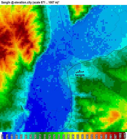
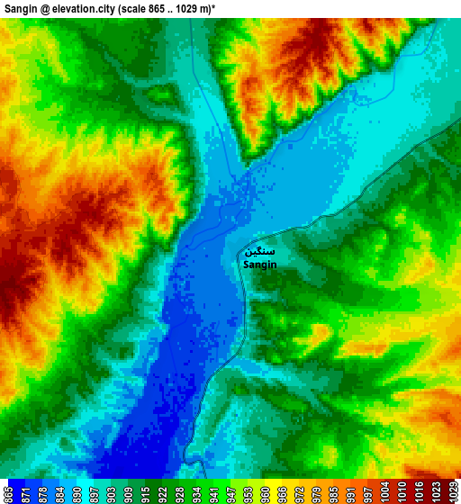
Below is the Elevation map of Sangīn, which displays elevation range with different colors. Scale of the first map is from 871 to 1007 m (2858 to 3304 ft) with average elevation of 910.5 meters (=2987 ft) [note 1]
These maps also provides idea of topography and contour of this city, they are displayed at different zoom levels. More info about maps, scale and edge coordinates you can find below images.
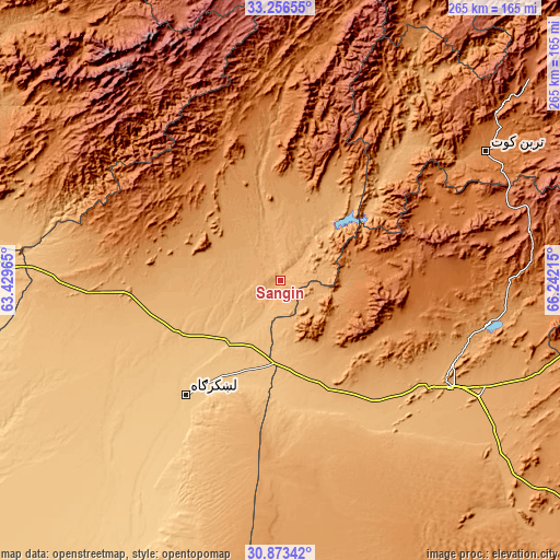
| \ | Map #1 | Map #2 | Topo.Map |
| Scale [m] | 871..1007 m | 865..1029 m | × |
| Scale [ft] | 2858..3304 ft | 2838..3376 ft | × |
| Average | 910.5 m = 2987 ft | 929.8 m = 3051 ft | × |
| Width | 8.28 km = 5.1 mi | 16.56 km = 10.3 mi | 265 km = 164.7 mi |
| Height | 8.28 km = 5.1 mi | 16.56 km = 10.3 mi | 265 km = 164.7 mi |
| ↑Max Latitude | 32.109981° | 32.147196° | 33.25655° |
| Latitude at center | 32.07275° | 32.07275° | 32.07275° |
| ↓Min Latitude | 32.035504° | 31.998243° | 30.87342° |
| ← Min Longitude | 64.791955° | 64.748009° | 63.42965° |
| Longitude center | 64.8359° | 64.8359° | 64.8359° |
| →Max Longitude | 64.879845° | 64.923791° | 66.24215° |
Nearby cities:
Cities around Sangīn sort by population:
• Lashkar Gāh elevation 786 m
69 km,  219°
219°
• Gereshk 830 m
37.6 km, 221°
• Wāshēr 1175 m
94.4 km,  282°
282°
• Babasakhib 1014 m
90.3 km,  120°
120°
• Dê Nārkhēl Kêlay 1478 m
85.1 km,  61°
61°
• Pāshmūl 946 m
80.5 km,  135°
135°
• Ḩukūmat-e Nād ‘Alī 797 m
73.8 km,  229°
229°
• Zīārat-e Shāh Maqşūd 1577 m
60.9 km,  99°
99°
• Kishk-e Nakhūd 944 m
53.9 km,  157°
157°
• Now Zād 1220 m
50.4 km,  316°
316°
• Mūsá Qal‘ah 1053 m
42.3 km,  348°
348°
• Chinār 1132 m
26.3 km, 103°
Multilingual:
 En español:
Sangīn elevación 885 m.
 En France:
Sangīn élévation 885 m.


Sources and notes:
- [note 1] Map square and city borders are not equal. Map elevation data is calculated only from area inside that square.
- [src 1] Elevation data from geonames database provided with same terms of usage.
- [src 2] The elevation map of Sangīn is generated using elevation data from NASA's 3 arcsec (90m) resolution SRTM data.
- [src 3] Base (background) map © OpenStreetMap contributors tiles are generated by Geofabrik and OpenTopoMap.
Copyright & License:
This Sangīn Elevation Map is licensed under CC BY-SA. You may reuse any part from this page, if you give a proper credit by linking to this URL:
 More info on terms of use page.