Khāsh elevation
Khāsh (Nimroz, Khāsh Rōd), Afghanistan elevation is 579 meters and Khāsh elevation in feet is 1900 ft above sea level [src 1]. Khāsh is a populated place (feature code) with elevation that is 840 meters (2756 ft) smaller than average city elevation in Afghanistan.
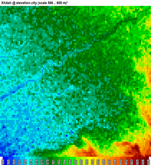
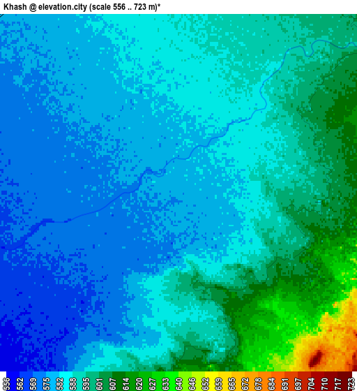
Below is the Elevation map of Khāsh, which displays elevation range with different colors. Scale of the first map is from 566 to 608 m (1857 to 1995 ft) with average elevation of 579.6 meters (=1902 ft) [note 1]
These maps also provides idea of topography and contour of this city, they are displayed at different zoom levels. More info about maps, scale and edge coordinates you can find below images.
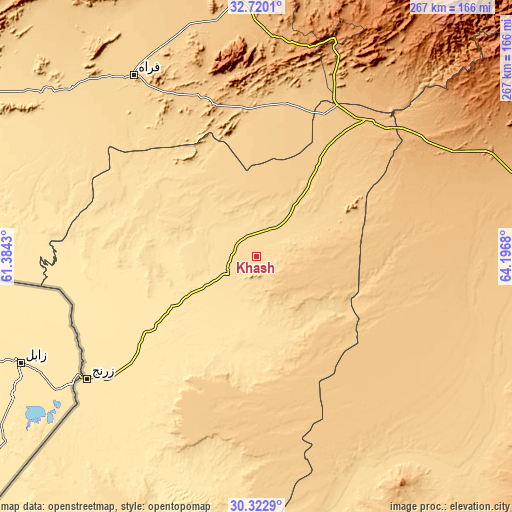
| \ | Map #1 | Map #2 | Topo.Map |
| Scale [m] | 566..608 m | 556..723 m | × |
| Scale [ft] | 1857..1995 ft | 1824..2372 ft | × |
| Average | 579.6 m = 1902 ft | 588.3 m = 1930 ft | × |
| Width | 8.33 km = 5.2 mi | 16.66 km = 10.4 mi | 266.5 km = 165.6 mi |
| Height | 8.33 km = 5.2 mi | 16.66 km = 10.4 mi | 266.5 km = 165.6 mi |
| ↑Max Latitude | 31.56664° | 31.604076° | 32.7201° |
| Latitude at center | 31.52919° | 31.52919° | 31.52919° |
| ↓Min Latitude | 31.491725° | 31.454244° | 30.3229° |
| ← Min Longitude | 62.746605° | 62.702659° | 61.3843° |
| Longitude center | 62.79055° | 62.79055° | 62.79055° |
| →Max Longitude | 62.834495° | 62.878441° | 64.1968° |
Nearby cities:
Cities around Khāsh sort by population:
• Zaranj elevation 489 m
108.8 km,  234°
234°
• Farah 662 m
113.5 km,  325°
325°
• ‘Alāqahdārī Dīshū 596 m
131.2 km,  158°
158°
• Markaz-e Ḩukūmat-e Darwēshān 714 m
140.4 km,  108°
108°
• Kushkak 612 m
146.6 km,  305°
305°
• Qal‘ah-ye Kuhnah 1429 m
146.3 km,  34°
34°
• Khān Neshīn 635 m
144.7 km,  138°
138°
• Dū Qal‘ah 557 m
144.1 km,  298°
298°
• Ḩukūmat-e Nād ‘Alī 797 m
137.9 km,  84°
84°
• Wāshēr 1175 m
128.7 km,  51°
51°
• Lāsh-e Juwayn 513 m
112.5 km,  280°
280°
• Markaz-e Ḩukūmat-e Sulţān-e Bakwāh 724 m
80.6 km,  10°
10°
Multilingual:
 En español:
Khāsh elevación 579 m.
 En France:
Khāsh élévation 579 m.


Sources and notes:
- [note 1] Map square and city borders are not equal. Map elevation data is calculated only from area inside that square.
- [src 1] Elevation data from geonames database provided with same terms of usage.
- [src 2] The elevation map of Khāsh is generated using elevation data from NASA's 3 arcsec (90m) resolution SRTM data.
- [src 3] Base (background) map © OpenStreetMap contributors tiles are generated by Geofabrik and OpenTopoMap.
Copyright & License:
This Khāsh Elevation Map is licensed under CC BY-SA. You may reuse any part from this page, if you give a proper credit by linking to this URL:
 More info on terms of use page.