‘Alāqahdārī Dīshū elevation
‘Alāqahdārī Dīshū (Helmand, Dīshū), Afghanistan elevation is 596 meters and ‘Alāqahdārī Dīshū elevation in feet is 1955 ft above sea level [src 1]. ‘Alāqahdārī Dīshū is a seat of a second-order administrative division (feature code) with elevation that is 823 meters (2700 ft) smaller than average city elevation in Afghanistan.
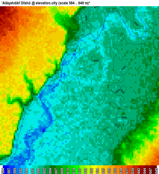
Below is the Elevation map of ‘Alāqahdārī Dīshū, which displays elevation range with different colors. Scale of the first map is from 584 to 649 m (1916 to 2129 ft) with average elevation of 606.3 meters (=1989 ft) [note 1]
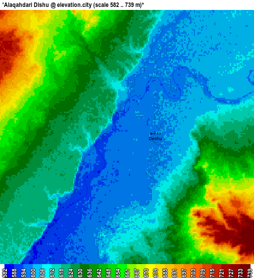
These maps also provides idea of topography and contour of this city, they are displayed at different zoom levels. More info about maps, scale and edge coordinates you can find below images.
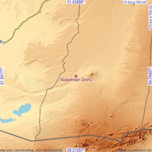
| \ | Map #1 | Map #2 | Topo.Map |
| Scale [m] | 584..649 m | 582..739 m | × |
| Scale [ft] | 1916..2129 ft | 1909..2425 ft | × |
| Average | 606.3 m = 1989 ft | 627.5 m = 2059 ft | × |
| Width | 8.43 km = 5.2 mi | 16.85 km = 10.5 mi | 269.6 km = 167.5 mi |
| Height | 8.43 km = 5.2 mi | 16.85 km = 10.5 mi | 269.6 km = 167.5 mi |
| ↑Max Latitude | 30.469944° | 30.507813° | 31.63698° |
| Latitude at center | 30.43206° | 30.43206° | 30.43206° |
| ↓Min Latitude | 30.394162° | 30.356249° | 29.21207° |
| ← Min Longitude | 63.254075° | 63.210129° | 61.89177° |
| Longitude center | 63.29802° | 63.29802° | 63.29802° |
| →Max Longitude | 63.341965° | 63.385911° | 64.70427° |
Nearby cities:
Cities around ‘Alāqahdārī Dīshū sort by population:
• Zaranj elevation 489 m
149.4 km,  293°
293°
• Lashkar Gāh 786 m
164.8 km,  38°
38°
• Gereshk 830 m
196.2 km, 38°
• Khāsh 579 m
131.2 km,  338°
338°
• Mīrābād 514 m
139.9 km,  270°
270°
• Rūdbār 556 m
74 km,  244°
244°
• Markaz-e Ḩukūmat-e Darwēshān 714 m
115.7 km,  47°
47°
• Kishk-e Nakhūd 944 m
213.6 km, 51°
• Wāshēr 1175 m
209.1 km,  14°
14°
• Markaz-e Ḩukūmat-e Sulţān-e Bakwāh 724 m
203.9 km,  350°
350°
• Ḩukūmat-e Nād ‘Alī 797 m
161.8 km,  33°
33°
• Khān Neshīn 635 m
48.8 km,  74°
74°
Multilingual:
 En español:
‘Alāqahdārī Dīshū elevación 596 m.
 En France:
‘Alāqahdārī Dīshū élévation 596 m.
 Auf Deutsch:
‘Alāqahdārī Dīshū höhe über dem Meeresspiegel ist 596 m.

Sources and notes:
- [note 1] Map square and city borders are not equal. Map elevation data is calculated only from area inside that square.
- [src 1] Elevation data from geonames database provided with same terms of usage.
- [src 2] The elevation map of ‘Alāqahdārī Dīshū is generated using elevation data from NASA's 3 arcsec (90m) resolution SRTM data.
- [src 3] Base (background) map © OpenStreetMap contributors tiles are generated by Geofabrik and OpenTopoMap.
Copyright & License:
This ‘Alāqahdārī Dīshū Elevation Map is licensed under CC BY-SA. You may reuse any part from this page, if you give a proper credit by linking to this URL:
 More info on terms of use page.