Chinsali elevation
Chinsali (Muchinga), Zambia elevation is 1286 meters and Chinsali elevation in feet is 4219 ft above sea level [src 1]. Chinsali is a seat of a first-order administrative division (feature code) with elevation that is 143 meters (469 ft) bigger than average city elevation in Zambia.
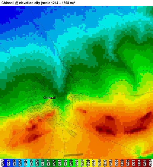
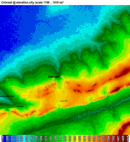
Below is the Elevation map of Chinsali, which displays elevation range with different colors. Scale of the first map is from 1214 to 1398 m (3983 to 4587 ft) with average elevation of 1293 meters (=4242 ft) [note 1]
These maps also provides idea of topography and contour of this city, they are displayed at different zoom levels. More info about maps, scale and edge coordinates you can find below images.
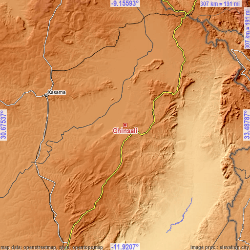
| \ | Map #1 | Map #2 | Topo.Map |
| Scale [m] | 1214..1398 m | 1196..1418 m | × |
| Scale [ft] | 3983..4587 ft | 3924..4652 ft | × |
| Average | 1293 m = 4242 ft | 1276.9 m = 4189 ft | × |
| Width | 9.61 km = 6 mi | 19.22 km = 11.9 mi | 307.4 km = 191 mi |
| Height | 9.61 km = 6 mi | 19.22 km = 11.9 mi | 307.4 km = 191 mi |
| ↑Max Latitude | -10.498213° | -10.455001° | -9.15593° |
| Latitude at center | -10.54142° | -10.54142° | -10.54142° |
| ↓Min Latitude | -10.584621° | -10.627815° | -11.9207° |
| ← Min Longitude | 32.037675° | 31.993729° | 30.67537° |
| Longitude center | 32.08162° | 32.08162° | 32.08162° |
| →Max Longitude | 32.125565° | 32.169511° | 33.48787° |
Nearby cities:
Cities around Chinsali sort by population:
• Kasama elevation 1394 m
105.1 km,  290°
290°
• Mpika 1428 m
159.3 km,  205°
205°
• Mbala 1622 m
204.8 km,  337°
337°
• Samfya 1183 m
290.5 km,  251°
251°
• Isoka 1321 m
73.7 km,  54°
54°
• Lundazi 1143 m
228.5 km,  148°
148°
• Nakonde 1589 m
151.9 km,  28°
28°
• Mpulungu 800 m
224.5 km,  331°
331°
• Mungwi 1382 m
88 km,  297°
297°
• Luwingu 1381 m
237.7 km,  277°
277°
• Chama 765 m
138.7 km,  122°
122°
• Mporokoso 1442 m
250.6 km, 301°
Multilingual:
 En español:
Chinsali elevación 1286 m.
 En France:
Chinsali élévation 1286 m.
 Auf Deutsch:
Chinsali höhe über dem Meeresspiegel ist 1286 m.

Sources and notes:
- [note 1] Map square and city borders are not equal. Map elevation data is calculated only from area inside that square.
- [src 1] Elevation data from geonames database provided with same terms of usage.
- [src 2] The elevation map of Chinsali is generated using elevation data from NASA's 3 arcsec (90m) resolution SRTM data.
- [src 3] Base (background) map © OpenStreetMap contributors tiles are generated by Geofabrik and OpenTopoMap.
Copyright & License:
This Chinsali Elevation Map is licensed under CC BY-SA. You may reuse any part from this page, if you give a proper credit by linking to this URL:
 More info on terms of use page.