Luwingu elevation
Luwingu (Northern), Zambia elevation is 1381 meters and Luwingu elevation in feet is 4531 ft above sea level [src 1]. Luwingu is a populated place (feature code) with elevation that is 238 meters (781 ft) bigger than average city elevation in Zambia.
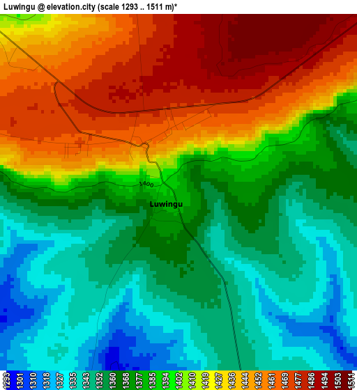
Below is the Elevation map of Luwingu, which displays elevation range with different colors. Scale of the first map is from 1293 to 1511 m (4242 to 4957 ft) with average elevation of 1393.9 meters (=4573 ft) [note 1]
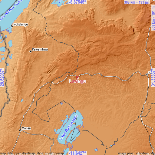
These maps also provides idea of topography and contour of this city, they are displayed at different zoom levels. More info about maps, scale and edge coordinates you can find below images.
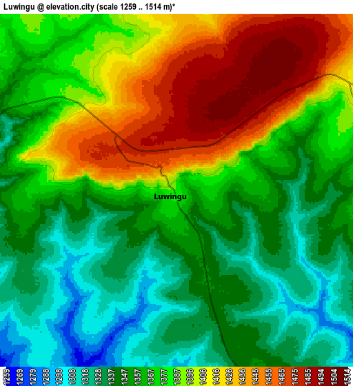
| \ | Map #1 | Map #2 | Topo.Map |
| Scale [m] | 1293..1511 m | 1259..1514 m | × |
| Scale [ft] | 4242..4957 ft | 4131..4967 ft | × |
| Average | 1393.9 m = 4573 ft | 1375 m = 4511 ft | × |
| Width | 9.62 km = 6 mi | 19.23 km = 11.9 mi | 307.7 km = 191.2 mi |
| Height | 9.62 km = 6 mi | 19.23 km = 11.9 mi | 307.7 km = 191.2 mi |
| ↑Max Latitude | -10.218855° | -10.175604° | -8.87545° |
| Latitude at center | -10.2621° | -10.2621° | -10.2621° |
| ↓Min Latitude | -10.305339° | -10.348573° | -11.6427° |
| ← Min Longitude | 29.883175° | 29.839229° | 28.52087° |
| Longitude center | 29.92712° | 29.92712° | 29.92712° |
| →Max Longitude | 29.971065° | 30.015011° | 31.33337° |
Nearby cities:
Cities around Luwingu sort by population:
• Kasama elevation 1394 m
137.3 km,  87°
87°
• Mansa 1216 m
153.6 km,  227°
227°
• Nchelenge 933 m
165.8 km,  307°
307°
• Kawambwa 1342 m
106.6 km,  299°
299°
• Mbala 1622 m
223.3 km,  44°
44°
• Samfya 1183 m
129.1 km,  198°
198°
• Kataba 1163 m
180.9 km,  184°
184°
• Mpulungu 800 m
211.5 km, 37°
• Mungwi 1382 m
158.1 km, 86°
• Mwense 959 m
135.1 km,  264°
264°
• Mporokoso 1442 m
101.2 km,  12°
12°
• Kaputa 950 m
201.5 km,  351°
351°
Multilingual:
 En español:
Luwingu elevación 1381 m.
 En France:
Luwingu élévation 1381 m.
 Auf Deutsch:
Luwingu höhe über dem Meeresspiegel ist 1381 m.

Sources and notes:
- [note 1] Map square and city borders are not equal. Map elevation data is calculated only from area inside that square.
- [src 1] Elevation data from geonames database provided with same terms of usage.
- [src 2] The elevation map of Luwingu is generated using elevation data from NASA's 3 arcsec (90m) resolution SRTM data.
- [src 3] Base (background) map © OpenStreetMap contributors tiles are generated by Geofabrik and OpenTopoMap.
Copyright & License:
This Luwingu Elevation Map is licensed under CC BY-SA. You may reuse any part from this page, if you give a proper credit by linking to this URL:
 More info on terms of use page.