Mwense elevation
Mwense (Luapula), Zambia elevation is 959 meters and Mwense elevation in feet is 3146 ft above sea level [src 1]. Mwense is a populated place (feature code) with elevation that is 184 meters (604 ft) smaller than average city elevation in Zambia.
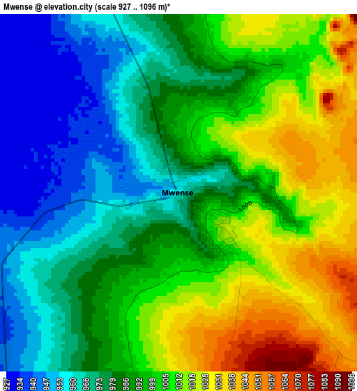
Below is the Elevation map of Mwense, which displays elevation range with different colors. Scale of the first map is from 927 to 1096 m (3041 to 3596 ft) with average elevation of 991.1 meters (=3252 ft) [note 1]
These maps also provides idea of topography and contour of this city, they are displayed at different zoom levels. More info about maps, scale and edge coordinates you can find below images.
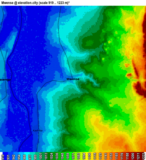
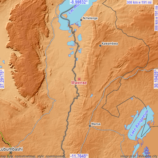
| \ | Map #1 | Map #2 | Topo.Map |
| Scale [m] | 927..1096 m | 919..1223 m | × |
| Scale [ft] | 3041..3596 ft | 3015..4012 ft | × |
| Average | 991.1 m = 3252 ft | 1006.1 m = 3301 ft | × |
| Width | 9.61 km = 6 mi | 19.22 km = 11.9 mi | 307.6 km = 191.1 mi |
| Height | 9.61 km = 6 mi | 19.22 km = 11.9 mi | 307.6 km = 191.1 mi |
| ↑Max Latitude | -10.341242° | -10.298007° | -8.99832° |
| Latitude at center | -10.38447° | -10.38447° | -10.38447° |
| ↓Min Latitude | -10.427693° | -10.470909° | -11.7645° |
| ← Min Longitude | 28.654055° | 28.610109° | 27.29175° |
| Longitude center | 28.698° | 28.698° | 28.698° |
| →Max Longitude | 28.741945° | 28.785891° | 30.10425° |
Nearby cities:
Cities around Mwense sort by population:
• Chingola elevation 1363 m
254.4 km,  200°
200°
• Mufulira 1285 m
245.9 km,  191°
191°
• Chililabombwe 1316 m
240 km, 203°
• Mansa 1216 m
93.2 km,  166°
166°
• Nchelenge 933 m
115.6 km,  1°
1°
• Kawambwa 1342 m
78 km,  32°
32°
• Samfya 1183 m
143.8 km,  139°
139°
• Kataba 1163 m
204.4 km, 144°
• Chambishi 1304 m
259.6 km, 195°
• Luwingu 1381 m
135.1 km,  84°
84°
• Mporokoso 1442 m
192.6 km,  54°
54°
• Kaputa 950 m
237.8 km, 26°
Multilingual:
 En español:
Mwense elevación 959 m.
 En France:
Mwense élévation 959 m.


Sources and notes:
- [note 1] Map square and city borders are not equal. Map elevation data is calculated only from area inside that square.
- [src 1] Elevation data from geonames database provided with same terms of usage.
- [src 2] The elevation map of Mwense is generated using elevation data from NASA's 3 arcsec (90m) resolution SRTM data.
- [src 3] Base (background) map © OpenStreetMap contributors tiles are generated by Geofabrik and OpenTopoMap.
Copyright & License:
This Mwense Elevation Map is licensed under CC BY-SA. You may reuse any part from this page, if you give a proper credit by linking to this URL:
 More info on terms of use page.