Chambishi elevation
Chambishi (Copperbelt), Zambia elevation is 1304 meters and Chambishi elevation in feet is 4278 ft above sea level [src 1]. Chambishi is a populated place (feature code) with elevation that is 161 meters (528 ft) bigger than average city elevation in Zambia.
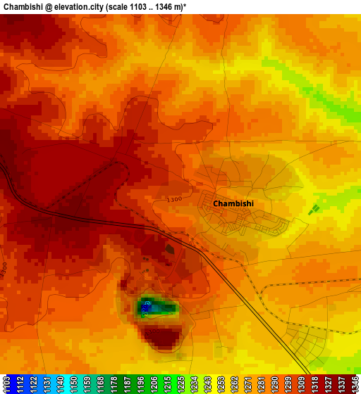
Below is the Elevation map of Chambishi, which displays elevation range with different colors. Scale of the first map is from 1103 to 1346 m (3619 to 4416 ft) with average elevation of 1286.6 meters (=4221 ft) [note 1]
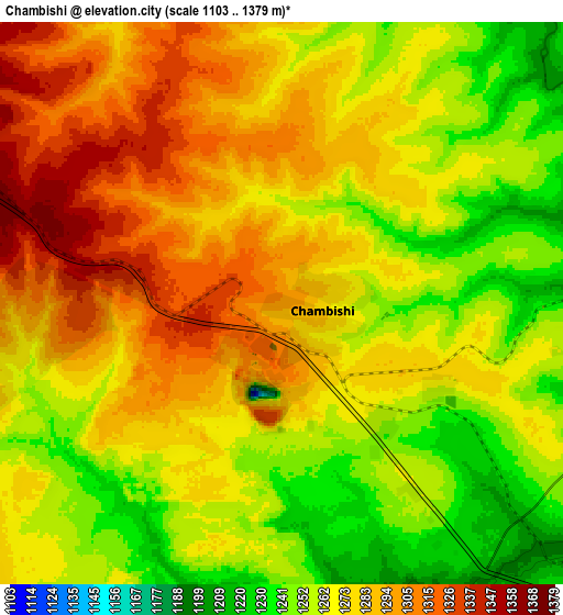
These maps also provides idea of topography and contour of this city, they are displayed at different zoom levels. More info about maps, scale and edge coordinates you can find below images.
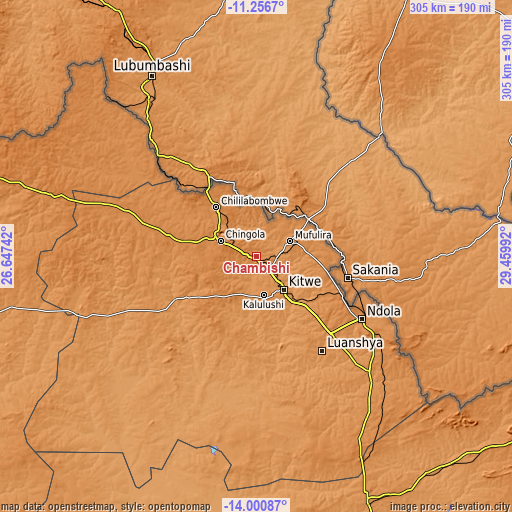
| \ | Map #1 | Map #2 | Topo.Map |
| Scale [m] | 1103..1346 m | 1103..1379 m | × |
| Scale [ft] | 3619..4416 ft | 3619..4524 ft | × |
| Average | 1286.6 m = 4221 ft | 1274.1 m = 4180 ft | × |
| Width | 9.54 km = 5.9 mi | 19.07 km = 11.8 mi | 305.1 km = 189.6 mi |
| Height | 9.54 km = 5.9 mi | 19.07 km = 11.8 mi | 305.1 km = 189.6 mi |
| ↑Max Latitude | -12.589585° | -12.546693° | -11.2567° |
| Latitude at center | -12.63247° | -12.63247° | -12.63247° |
| ↓Min Latitude | -12.675348° | -12.718219° | -14.00087° |
| ← Min Longitude | 28.009725° | 27.965779° | 26.64742° |
| Longitude center | 28.05367° | 28.05367° | 28.05367° |
| →Max Longitude | 28.097615° | 28.141561° | 29.45992° |
Nearby cities:
Cities around Chambishi sort by population:
• Kitwe elevation 1224 m
25.6 km,  137°
137°
• Ndola 1307 m
72.9 km,  119°
119°
• Chingola 1363 m
21.7 km,  301°
301°
• Mufulira 1285 m
22.3 km,  65°
65°
• Luanshya 1238 m
68.5 km, 144°
• Kalulushi 1304 m
23.7 km,  169°
169°
• Chililabombwe 1316 m
38.9 km,  319°
319°
• Mansa 1216 m
183.7 km,  29°
29°
• Kansanshi 1429 m
186.5 km,  288°
288°
• Kapiri Mposhi 1265 m
163.1 km,  155°
155°
• Mkushi 1257 m
182 km,  127°
127°
• Mpongwe 1195 m
98.1 km, 173°
Multilingual:
 En español:
Chambishi elevación 1304 m.
 En France:
Chambishi élévation 1304 m.
 Auf Deutsch:
Chambishi höhe über dem Meeresspiegel ist 1304 m.

Sources and notes:
- [note 1] Map square and city borders are not equal. Map elevation data is calculated only from area inside that square.
- [src 1] Elevation data from geonames database provided with same terms of usage.
- [src 2] The elevation map of Chambishi is generated using elevation data from NASA's 3 arcsec (90m) resolution SRTM data.
- [src 3] Base (background) map © OpenStreetMap contributors tiles are generated by Geofabrik and OpenTopoMap.
Copyright & License:
This Chambishi Elevation Map is licensed under CC BY-SA. You may reuse any part from this page, if you give a proper credit by linking to this URL:
 More info on terms of use page.