Lundazi elevation
Lundazi (Eastern), Zambia elevation is 1143 meters and Lundazi elevation in feet is 3750 ft above sea level [src 1]. Lundazi is a populated place (feature code) with elevation that is 0 meters (0 ft) bigger than average city elevation in Zambia.
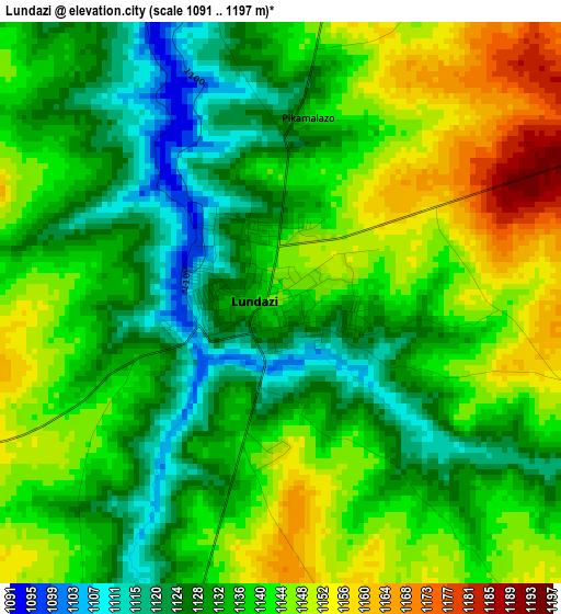
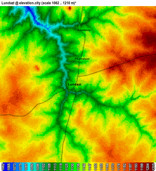
Below is the Elevation map of Lundazi, which displays elevation range with different colors. Scale of the first map is from 1091 to 1197 m (3579 to 3927 ft) with average elevation of 1137.5 meters (=3732 ft) [note 1]
These maps also provides idea of topography and contour of this city, they are displayed at different zoom levels. More info about maps, scale and edge coordinates you can find below images.
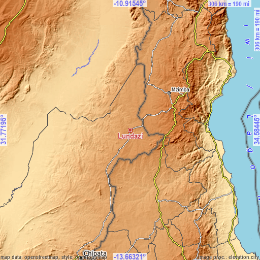
| \ | Map #1 | Map #2 | Topo.Map |
| Scale [m] | 1091..1197 m | 1062..1210 m | × |
| Scale [ft] | 3579..3927 ft | 3484..3970 ft | × |
| Average | 1137.5 m = 3732 ft | 1147.7 m = 3765 ft | × |
| Width | 9.55 km = 5.9 mi | 19.1 km = 11.9 mi | 305.5 km = 189.8 mi |
| Height | 9.55 km = 5.9 mi | 19.1 km = 11.9 mi | 305.5 km = 189.8 mi |
| ↑Max Latitude | -12.249979° | -12.207031° | -10.91545° |
| Latitude at center | -12.29292° | -12.29292° | -12.29292° |
| ↓Min Latitude | -12.335854° | -12.378781° | -13.66321° |
| ← Min Longitude | 33.134255° | 33.090309° | 31.77195° |
| Longitude center | 33.1782° | 33.1782° | 33.1782° |
| →Max Longitude | 33.222145° | 33.266091° | 34.58445° |
Nearby cities:
Cities around Lundazi sort by population:
• Kasama elevation 1394 m
317.7 km,  316°
316°
• Chipata 1147 m
159.7 km,  201°
201°
• Mpika 1428 m
194.4 km,  285°
285°
• Petauke 1015 m
295.6 km,  222°
222°
• Chinsali 1286 m
228.5 km,  328°
328°
• Isoka 1321 m
244.4 km,  345°
345°
• Nakonde 1589 m
331.5 km, 351°
• Serenje 1424 m
335.8 km,  251°
251°
• Mungwi 1382 m
307.3 km, 320°
• Chama 765 m
120.1 km,  358°
358°
• Chadiza 1066 m
212.9 km, 202°
• Nyimba 716 m
358.7 km,  225°
225°
Multilingual:
 En español:
Lundazi elevación 1143 m.
 En France:
Lundazi élévation 1143 m.
 Auf Deutsch:
Lundazi höhe über dem Meeresspiegel ist 1143 m.

Sources and notes:
- [note 1] Map square and city borders are not equal. Map elevation data is calculated only from area inside that square.
- [src 1] Elevation data from geonames database provided with same terms of usage.
- [src 2] The elevation map of Lundazi is generated using elevation data from NASA's 3 arcsec (90m) resolution SRTM data.
- [src 3] Base (background) map © OpenStreetMap contributors tiles are generated by Geofabrik and OpenTopoMap.
Copyright & License:
This Lundazi Elevation Map is licensed under CC BY-SA. You may reuse any part from this page, if you give a proper credit by linking to this URL:
 More info on terms of use page.