Petauke elevation
Petauke (Eastern, Petauke District), Zambia elevation is 1015 meters and Petauke elevation in feet is 3330 ft above sea level [src 1]. Petauke is a populated place (feature code) with elevation that is 128 meters (420 ft) smaller than average city elevation in Zambia.
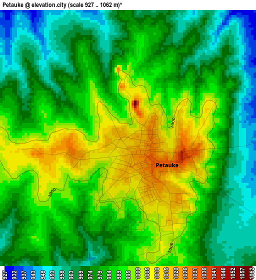
Below is the Elevation map of Petauke, which displays elevation range with different colors. Scale of the first map is from 927 to 1062 m (3041 to 3484 ft) with average elevation of 982.3 meters (=3223 ft) [note 1]
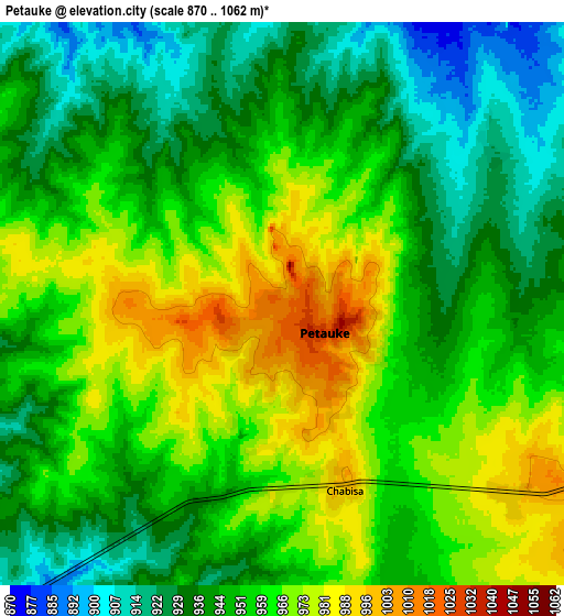
These maps also provides idea of topography and contour of this city, they are displayed at different zoom levels. More info about maps, scale and edge coordinates you can find below images.
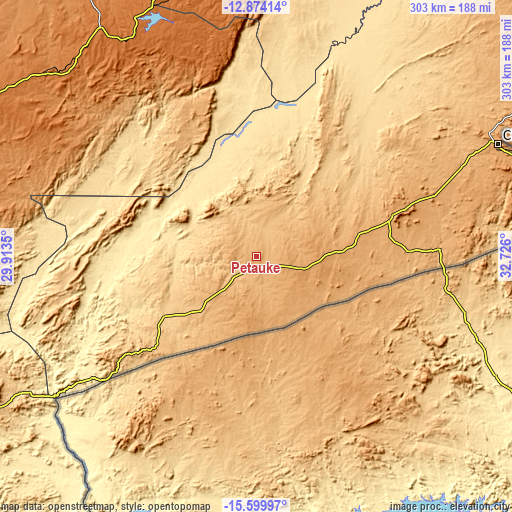
| \ | Map #1 | Map #2 | Topo.Map |
| Scale [m] | 927..1062 m | 870..1062 m | × |
| Scale [ft] | 3041..3484 ft | 2854..3484 ft | × |
| Average | 982.3 m = 3223 ft | 952.3 m = 3124 ft | × |
| Width | 9.47 km = 5.9 mi | 18.94 km = 11.8 mi | 303.1 km = 188.3 mi |
| Height | 9.47 km = 5.9 mi | 18.94 km = 11.8 mi | 303.1 km = 188.3 mi |
| ↑Max Latitude | -14.198571° | -14.155964° | -12.87414° |
| Latitude at center | -14.24117° | -14.24117° | -14.24117° |
| ↓Min Latitude | -14.283761° | -14.326344° | -15.59997° |
| ← Min Longitude | 31.275805° | 31.231859° | 29.9135° |
| Longitude center | 31.31975° | 31.31975° | 31.31975° |
| →Max Longitude | 31.363695° | 31.407641° | 32.726° |
Nearby cities:
Cities around Petauke sort by population:
• Kabwe elevation 1191 m
310.4 km,  265°
265°
• Chipata 1147 m
158.7 km,  64°
64°
• Kapiri Mposhi 1265 m
287.3 km,  275°
275°
• Mpika 1428 m
268 km,  3°
3°
• Kataba 1163 m
310.5 km,  327°
327°
• Mkushi 1257 m
219 km,  288°
288°
• Lundazi 1143 m
295.6 km,  42°
42°
• Serenje 1424 m
162.2 km,  313°
313°
• Chongwe 1102 m
308.3 km,  246°
246°
• Chadiza 1066 m
122.2 km,  80°
80°
• Luangwa 328 m
181.1 km,  212°
212°
• Nyimba 716 m
64.7 km,  237°
237°
Multilingual:
 En español:
Petauke elevación 1015 m.
 En France:
Petauke élévation 1015 m.
 Auf Deutsch:
Petauke höhe über dem Meeresspiegel ist 1015 m.

Sources and notes:
- [note 1] Map square and city borders are not equal. Map elevation data is calculated only from area inside that square.
- [src 1] Elevation data from geonames database provided with same terms of usage.
- [src 2] The elevation map of Petauke is generated using elevation data from NASA's 3 arcsec (90m) resolution SRTM data.
- [src 3] Base (background) map © OpenStreetMap contributors tiles are generated by Geofabrik and OpenTopoMap.
Copyright & License:
This Petauke Elevation Map is licensed under CC BY-SA. You may reuse any part from this page, if you give a proper credit by linking to this URL:
 More info on terms of use page.