Kabwe elevation
Kabwe (Central), Zambia elevation is 1191 meters and Kabwe elevation in feet is 3907 ft above sea level [src 1]. Kabwe is a seat of a first-order administrative division (feature code) with elevation that is 48 meters (157 ft) bigger than average city elevation in Zambia.
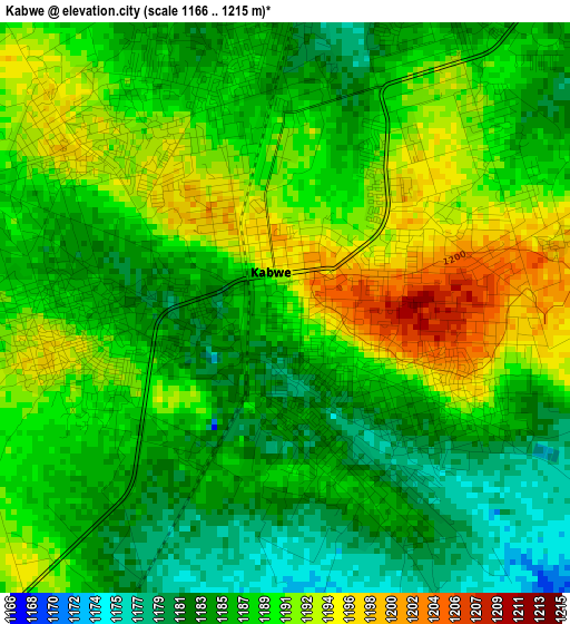
Below is the Elevation map of Kabwe, which displays elevation range with different colors. Scale of the first map is from 1166 to 1215 m (3825 to 3986 ft) with average elevation of 1187.8 meters (=3897 ft) [note 1]
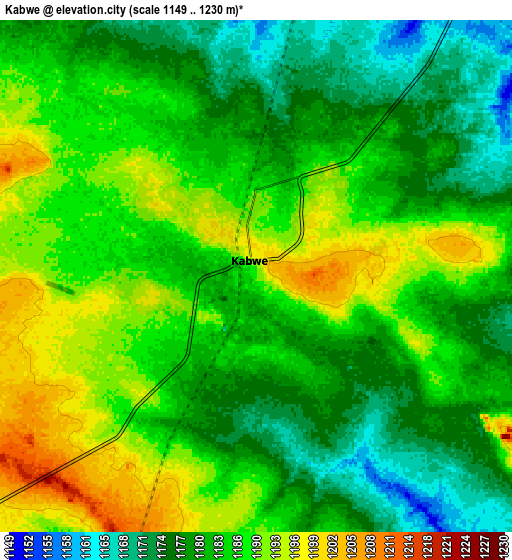
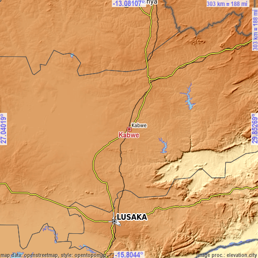
These maps also provides idea of topography and contour of this city, they are displayed at different zoom levels. More info about maps, scale and edge coordinates you can find below images.
| \ | Map #1 | Map #2 | Topo.Map |
| Scale [m] | 1166..1215 m | 1149..1230 m | × |
| Scale [ft] | 3825..3986 ft | 3770..4035 ft | × |
| Average | 1187.8 m = 3897 ft | 1183.9 m = 3884 ft | × |
| Width | 9.46 km = 5.9 mi | 18.93 km = 11.8 mi | 302.8 km = 188.2 mi |
| Height | 9.46 km = 5.9 mi | 18.93 km = 11.8 mi | 302.8 km = 188.2 mi |
| ↑Max Latitude | -14.40434° | -14.361772° | -13.08107° |
| Latitude at center | -14.4469° | -14.4469° | -14.4469° |
| ↓Min Latitude | -14.489452° | -14.531995° | -15.8044° |
| ← Min Longitude | 28.402495° | 28.358549° | 27.04019° |
| Longitude center | 28.44644° | 28.44644° | 28.44644° |
| →Max Longitude | 28.490385° | 28.534331° | 29.85269° |
Nearby cities:
Cities around Kabwe sort by population:
• Lusaka elevation 1277 m
108.1 km,  189°
189°
• Ndola 1307 m
166.7 km,  7°
7°
• Luanshya 1238 m
145.7 km,  358°
358°
• Mazabuka 1050 m
173.7 km,  205°
205°
• Kafue 996 m
149.7 km, 190°
• Kapiri Mposhi 1265 m
58.1 km,  24°
24°
• Mumbwa 1185 m
160.4 km,  248°
248°
• Mkushi 1257 m
137.5 km,  48°
48°
• Nakambala 1023 m
169.9 km,  204°
204°
• Mpongwe 1195 m
108.9 km,  343°
343°
• Chongwe 1102 m
101.3 km,  165°
165°
• Chibombo 1156 m
46.7 km,  240°
240°
Multilingual:
 En español:
Kabwe elevación 1191 m.
 En France:
Kabwe élévation 1191 m.


Sources and notes:
- [note 1] Map square and city borders are not equal. Map elevation data is calculated only from area inside that square.
- [src 1] Elevation data from geonames database provided with same terms of usage.
- [src 2] The elevation map of Kabwe is generated using elevation data from NASA's 3 arcsec (90m) resolution SRTM data.
- [src 3] Base (background) map © OpenStreetMap contributors tiles are generated by Geofabrik and OpenTopoMap.
Copyright & License:
This Kabwe Elevation Map is licensed under CC BY-SA. You may reuse any part from this page, if you give a proper credit by linking to this URL:
 More info on terms of use page.