Mazabuka elevation
Mazabuka (Southern), Zambia elevation is 1050 meters and Mazabuka elevation in feet is 3445 ft above sea level [src 1]. Mazabuka is a populated place (feature code) with elevation that is 93 meters (305 ft) smaller than average city elevation in Zambia.
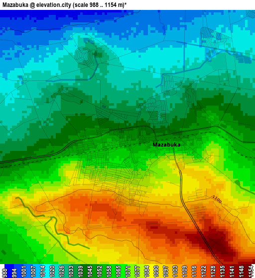
Below is the Elevation map of Mazabuka, which displays elevation range with different colors. Scale of the first map is from 988 to 1154 m (3241 to 3786 ft) with average elevation of 1054.7 meters (=3460 ft) [note 1]
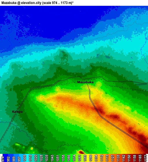
These maps also provides idea of topography and contour of this city, they are displayed at different zoom levels. More info about maps, scale and edge coordinates you can find below images.
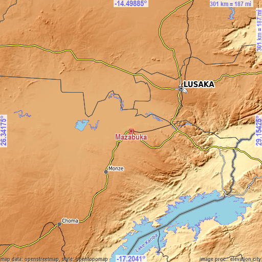
| \ | Map #1 | Map #2 | Topo.Map |
| Scale [m] | 988..1154 m | 974..1173 m | × |
| Scale [ft] | 3241..3786 ft | 3196..3848 ft | × |
| Average | 1054.7 m = 3460 ft | 1035.9 m = 3399 ft | × |
| Width | 9.4 km = 5.8 mi | 18.8 km = 11.7 mi | 300.8 km = 186.9 mi |
| Height | 9.4 km = 5.8 mi | 18.8 km = 11.7 mi | 300.8 km = 186.9 mi |
| ↑Max Latitude | -15.813732° | -15.771446° | -14.49885° |
| Latitude at center | -15.85601° | -15.85601° | -15.85601° |
| ↓Min Latitude | -15.898279° | -15.940539° | -17.2041° |
| ← Min Longitude | 27.704055° | 27.660109° | 26.34175° |
| Longitude center | 27.748° | 27.748° | 27.748° |
| →Max Longitude | 27.791945° | 27.835891° | 29.15425° |
Nearby cities:
Cities around Mazabuka sort by population:
• Lusaka elevation 1277 m
76.3 km,  49°
49°
• Kafue 996 m
47.4 km,  78°
78°
• Choma 1317 m
133.5 km,  217°
217°
• Monze 1124 m
55.3 km,  210°
210°
• Mumbwa 1185 m
121.8 km,  322°
322°
• Siavonga 528 m
127.6 km,  126°
126°
• Sinazongwe 504 m
159.2 km,  191°
191°
• Nakambala 1023 m
4.3 km, 52°
• Chongwe 1102 m
115.9 km,  59°
59°
• Chibombo 1156 m
137.8 km,  14°
14°
• Namwala 999 m
140.6 km,  274°
274°
• Gwembe 1247 m
72.9 km, 191°
Multilingual:
 En español:
Mazabuka elevación 1050 m.
 En France:
Mazabuka élévation 1050 m.
 Auf Deutsch:
Mazabuka höhe über dem Meeresspiegel ist 1050 m.

Sources and notes:
- [note 1] Map square and city borders are not equal. Map elevation data is calculated only from area inside that square.
- [src 1] Elevation data from geonames database provided with same terms of usage.
- [src 2] The elevation map of Mazabuka is generated using elevation data from NASA's 3 arcsec (90m) resolution SRTM data.
- [src 3] Base (background) map © OpenStreetMap contributors tiles are generated by Geofabrik and OpenTopoMap.
Copyright & License:
This Mazabuka Elevation Map is licensed under CC BY-SA. You may reuse any part from this page, if you give a proper credit by linking to this URL:
 More info on terms of use page.