Apel elevation
Apel (Limpopo, Sekhukhune District Municipality), South Africa elevation is 768 meters and Apel elevation in feet is 2520 ft above sea level [src 1]. Apel is a seat of a third-order administrative division (feature code) with elevation that is 204 meters (669 ft) smaller than average city elevation in South Africa.
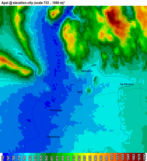
Below is the Elevation map of Apel, which displays elevation range with different colors. Scale of the first map is from 733 to 1090 m (2405 to 3576 ft) with average elevation of 813.8 meters (=2670 ft) [note 1]
These maps also provides idea of topography and contour of this city, they are displayed at different zoom levels. More info about maps, scale and edge coordinates you can find below images.
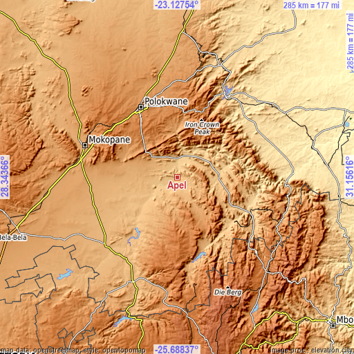
| \ | Map #1 | Topo.Map |
| Scale [m] | 733..1090 m | × |
| Scale [ft] | 2405..3576 ft | × |
| Average | 813.8 m = 2670 ft | × |
| Width | 8.9 km = 5.5 mi | 284.7 km = 176.9 mi |
| Height | 8.9 km = 5.5 mi | 284.8 km = 177 mi |
| ↑Max Latitude | -24.374428° | -23.12754° |
| Latitude at center | -24.41445° | -24.41445° |
| ↓Min Latitude | -24.454459° | -25.68837° |
| ← Min Longitude | 29.705965° | 28.34366° |
| Longitude center | 29.74991° | 29.74991° |
| →Max Longitude | 29.793855° | 31.15616° |
Nearby cities:
Cities around Apel sort by population:
• Polokwane elevation 1315 m
63.5 km,  333°
333°
• Mokopane 1117 m
78.9 km,  288°
288°
• Lebowakgomo 1161 m
34.8 km,  313°
313°
• Nkowakowa 584 m
80 km,  42°
42°
• Duiwelskloof 875 m
89.4 km,  26°
26°
• Tzaneen 719 m
77.1 km, 33°
• Ga-Kgapane 774 m
98.3 km, 29°
• Mankoeng 1389 m
57.6 km,  6°
6°
• Groblersdal 928 m
91.2 km,  203°
203°
• Marble Hall 902 m
76.9 km,  217°
217°
• Burgersfort 761 m
65.3 km,  116°
116°
• Jane Furse 1420 m
40.3 km,  162°
162°
Multilingual:
 En español:
Apel elevación 768 m.
 En France:
Apel élévation 768 m.


Sources and notes:
- [note 1] Map square and city borders are not equal. Map elevation data is calculated only from area inside that square.
- [src 1] Elevation data from geonames database provided with same terms of usage.
- [src 2] The elevation map of Apel is generated using elevation data from NASA's 3 arcsec (90m) resolution SRTM data.
- [src 3] Base (background) map © OpenStreetMap contributors tiles are generated by Geofabrik and OpenTopoMap.
Copyright & License:
This Apel Elevation Map is licensed under CC BY-SA. You may reuse any part from this page, if you give a proper credit by linking to this URL:
 More info on terms of use page.