Marble Hall elevation
Marble Hall (Mpumalanga), South Africa elevation is 902 meters and Marble Hall elevation in feet is 2959 ft above sea level [src 1]. Marble Hall is a seat of a third-order administrative division (feature code) with elevation that is 70 meters (230 ft) smaller than average city elevation in South Africa.
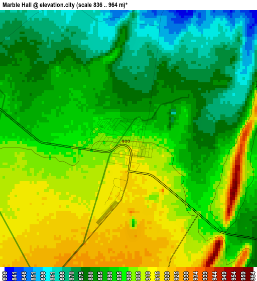
Below is the Elevation map of Marble Hall, which displays elevation range with different colors. Scale of the first map is from 836 to 964 m (2743 to 3163 ft) with average elevation of 892.4 meters (=2928 ft) [note 1]
These maps also provides idea of topography and contour of this city, they are displayed at different zoom levels. More info about maps, scale and edge coordinates you can find below images.
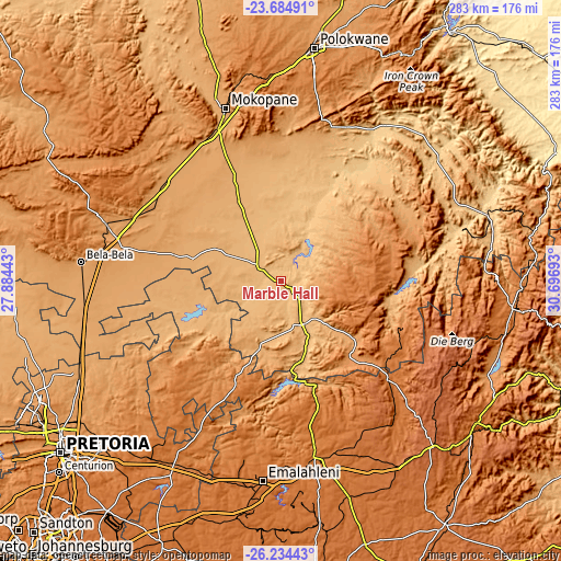
| \ | Map #1 | Topo.Map |
| Scale [m] | 836..964 m | × |
| Scale [ft] | 2743..3163 ft | × |
| Average | 892.4 m = 2928 ft | × |
| Width | 8.86 km = 5.5 mi | 283.5 km = 176.2 mi |
| Height | 8.86 km = 5.5 mi | 283.5 km = 176.2 mi |
| ↑Max Latitude | -24.926425° | -23.68491° |
| Latitude at center | -24.96627° | -24.96627° |
| ↓Min Latitude | -25.006102° | -26.23443° |
| ← Min Longitude | 29.246735° | 27.88443° |
| Longitude center | 29.29068° | 29.29068° |
| →Max Longitude | 29.334625° | 30.69693° |
Nearby cities:
Cities around Marble Hall sort by population:
• Witbank elevation 1629 m
100.8 km,  183°
183°
• Middelburg 1479 m
91.6 km,  168°
168°
• Mokopane 1117 m
90.4 km,  341°
341°
• Warmbaths 1136 m
102 km,  275°
275°
• Ekangala 1504 m
97.7 km,  213°
213°
• Lebowakgomo 1161 m
87.8 km,  13°
13°
• Siyabuswa 935 m
29.7 km,  236°
236°
• Modimolle 1177 m
94.6 km,  288°
288°
• Bela-Bela 1130 m
100.9 km, 275°
• Apel 768 m
76.9 km,  37°
37°
• Jane Furse 1420 m
62.8 km,  68°
68°
• Groblersdal 928 m
24.8 km,  155°
155°
Multilingual:
 En español:
Marble Hall elevación 902 m.
 En France:
Marble Hall élévation 902 m.
 Auf Deutsch:
Marble Hall höhe über dem Meeresspiegel ist 902 m.

Sources and notes:
- [note 1] Map square and city borders are not equal. Map elevation data is calculated only from area inside that square.
- [src 1] Elevation data from geonames database provided with same terms of usage.
- [src 2] The elevation map of Marble Hall is generated using elevation data from NASA's 3 arcsec (90m) resolution SRTM data.
- [src 3] Base (background) map © OpenStreetMap contributors tiles are generated by Geofabrik and OpenTopoMap.
Copyright & License:
This Marble Hall Elevation Map is licensed under CC BY-SA. You may reuse any part from this page, if you give a proper credit by linking to this URL:
 More info on terms of use page.