Ekangala elevation
Ekangala (Gauteng, City of Tshwane Metropolitan Municipality), South Africa elevation is 1504 meters and Ekangala elevation in feet is 4934 ft above sea level [src 1]. Ekangala is a populated place (feature code) with elevation that is 532 meters (1745 ft) bigger than average city elevation in South Africa.
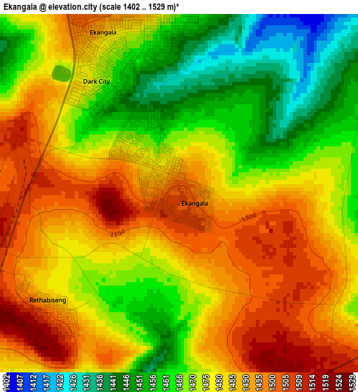
Below is the Elevation map of Ekangala, which displays elevation range with different colors. Scale of the first map is from 1402 to 1529 m (4600 to 5016 ft) with average elevation of 1477.4 meters (=4847 ft) [note 1]
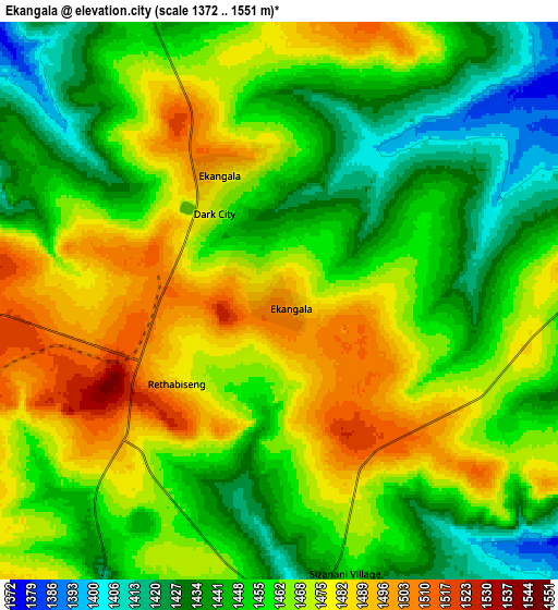
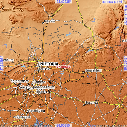
These maps also provides idea of topography and contour of this city, they are displayed at different zoom levels. More info about maps, scale and edge coordinates you can find below images.
| \ | Map #1 | Map #2 | Topo.Map |
| Scale [m] | 1402..1529 m | 1372..1551 m | × |
| Scale [ft] | 4600..5016 ft | 4501..5089 ft | × |
| Average | 1477.4 m = 4847 ft | 1460.4 m = 4791 ft | × |
| Width | 8.81 km = 5.5 mi | 17.61 km = 10.9 mi | 281.8 km = 175.1 mi |
| Height | 8.81 km = 5.5 mi | 17.61 km = 10.9 mi | 281.8 km = 175.1 mi |
| ↑Max Latitude | -25.656584° | -25.616965° | -24.42235° |
| Latitude at center | -25.69619° | -25.69619° | -25.69619° |
| ↓Min Latitude | -25.735783° | -25.775362° | -26.95655° |
| ← Min Longitude | 28.705235° | 28.661289° | 27.34293° |
| Longitude center | 28.74918° | 28.74918° | 28.74918° |
| →Max Longitude | 28.793125° | 28.837071° | 30.15543° |
Nearby cities:
Cities around Ekangala sort by population:
• Pretoria elevation 1332 m
56.5 km,  264°
264°
• Benoni 1641 m
69.5 km,  218°
218°
• Tembisa 1577 m
62 km,  237°
237°
• Witbank 1629 m
52.2 km,  111°
111°
• Centurion 1432 m
59.2 km,  252°
252°
• Springs 1630 m
70.8 km,  209°
209°
• Midrand 1562 m
70.2 km, 242°
• Mabopane 1225 m
68.7 km,  288°
288°
• Delmas 1558 m
50.5 km,  187°
187°
• Bronkhorstspruit 1399 m
12.7 km,  183°
183°
• Cullinan 1449 m
22.8 km,  277°
277°
• Midstream 1520 m
60.4 km, 245°
Multilingual:
 En español:
Ekangala elevación 1504 m.
 En France:
Ekangala élévation 1504 m.
 Auf Deutsch:
Ekangala höhe über dem Meeresspiegel ist 1504 m.

Sources and notes:
- [note 1] Map square and city borders are not equal. Map elevation data is calculated only from area inside that square.
- [src 1] Elevation data from geonames database provided with same terms of usage.
- [src 2] The elevation map of Ekangala is generated using elevation data from NASA's 3 arcsec (90m) resolution SRTM data.
- [src 3] Base (background) map © OpenStreetMap contributors tiles are generated by Geofabrik and OpenTopoMap.
Copyright & License:
This Ekangala Elevation Map is licensed under CC BY-SA. You may reuse any part from this page, if you give a proper credit by linking to this URL:
 More info on terms of use page.