Mabopane elevation
Mabopane (Gauteng, City of Tshwane Metropolitan Municipality), South Africa elevation is 1225 meters and Mabopane elevation in feet is 4019 ft above sea level [src 1]. Mabopane is a populated place (feature code) with elevation that is 253 meters (830 ft) bigger than average city elevation in South Africa.
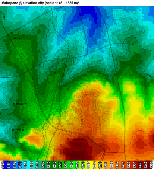
Below is the Elevation map of Mabopane, which displays elevation range with different colors. Scale of the first map is from 1146 to 1355 m (3760 to 4446 ft) with average elevation of 1232 meters (=4042 ft) [note 1]
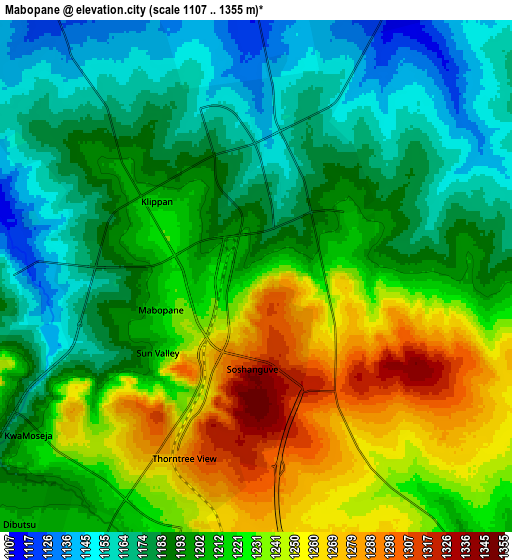
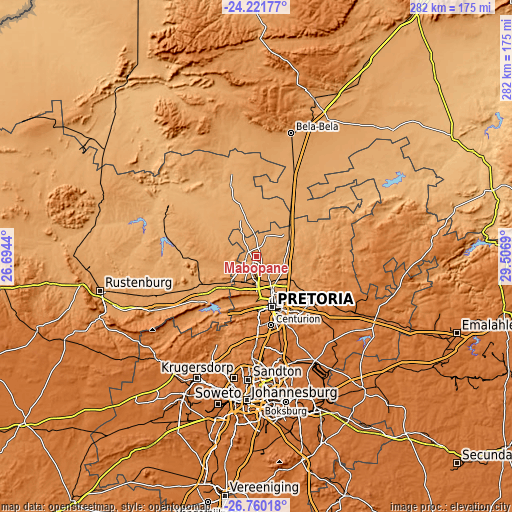
These maps also provides idea of topography and contour of this city, they are displayed at different zoom levels. More info about maps, scale and edge coordinates you can find below images.
| \ | Map #1 | Map #2 | Topo.Map |
| Scale [m] | 1146..1355 m | 1107..1355 m | × |
| Scale [ft] | 3760..4446 ft | 3632..4446 ft | × |
| Average | 1232 m = 4042 ft | 1208.2 m = 3964 ft | × |
| Width | 8.82 km = 5.5 mi | 17.64 km = 11 mi | 282.2 km = 175.4 mi |
| Height | 8.82 km = 5.5 mi | 17.64 km = 11 mi | 282.3 km = 175.4 mi |
| ↑Max Latitude | -25.458008° | -25.418324° | -24.22177° |
| Latitude at center | -25.49768° | -25.49768° | -25.49768° |
| ↓Min Latitude | -25.537339° | -25.576984° | -26.76018° |
| ← Min Longitude | 28.056705° | 28.012759° | 26.6944° |
| Longitude center | 28.10065° | 28.10065° | 28.10065° |
| →Max Longitude | 28.144595° | 28.188541° | 29.5069° |
Nearby cities:
Cities around Mabopane sort by population:
• Pretoria elevation 1332 m
28.8 km,  162°
162°
• Tembisa 1577 m
56.9 km,  167°
167°
• Diepsloot 1410 m
49.2 km,  190°
190°
• Centurion 1432 m
41.1 km, 168°
• Midrand 1562 m
54.8 km,  177°
177°
• Brits 1118 m
35.6 km,  244°
244°
• Ga-Rankuwa 1246 m
17 km,  218°
218°
• Cullinan 1449 m
46.6 km,  114°
114°
• Midstream 1520 m
47.8 km, 168°
• Modderfontein 1625 m
66.1 km, 174°
• Muldersdriseloop 1441 m
65.5 km,  203°
203°
• Makapanstad 1037 m
28.4 km,  5°
5°
Multilingual:
 En español:
Mabopane elevación 1225 m.
 En France:
Mabopane élévation 1225 m.
 Auf Deutsch:
Mabopane höhe über dem Meeresspiegel ist 1225 m.

Sources and notes:
- [note 1] Map square and city borders are not equal. Map elevation data is calculated only from area inside that square.
- [src 1] Elevation data from geonames database provided with same terms of usage.
- [src 2] The elevation map of Mabopane is generated using elevation data from NASA's 3 arcsec (90m) resolution SRTM data.
- [src 3] Base (background) map © OpenStreetMap contributors tiles are generated by Geofabrik and OpenTopoMap.
Copyright & License:
This Mabopane Elevation Map is licensed under CC BY-SA. You may reuse any part from this page, if you give a proper credit by linking to this URL:
 More info on terms of use page.