Mankoeng elevation
Mankoeng (Limpopo, Capricorn District Municipality), South Africa elevation is 1389 meters and Mankoeng elevation in feet is 4557 ft above sea level [src 1]. Mankoeng is a populated place (feature code) with elevation that is 417 meters (1368 ft) bigger than average city elevation in South Africa.
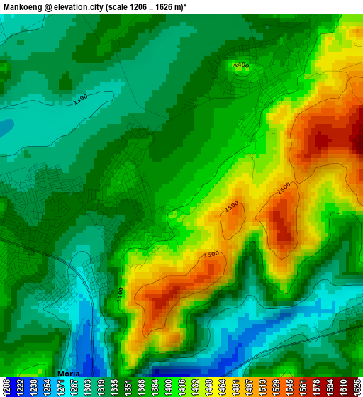
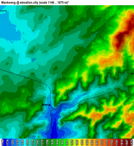
Below is the Elevation map of Mankoeng, which displays elevation range with different colors. Scale of the first map is from 1206 to 1626 m (3957 to 5335 ft) with average elevation of 1370.3 meters (=4496 ft) [note 1]
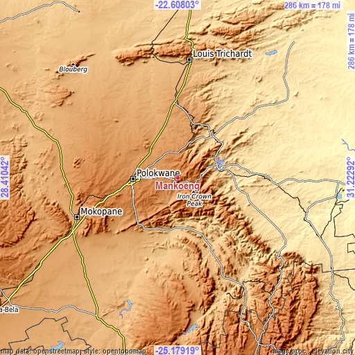
These maps also provides idea of topography and contour of this city, they are displayed at different zoom levels. More info about maps, scale and edge coordinates you can find below images.
| \ | Map #1 | Map #2 | Topo.Map |
| Scale [m] | 1206..1626 m | 1146..1875 m | × |
| Scale [ft] | 3957..5335 ft | 3760..6152 ft | × |
| Average | 1370.3 m = 4496 ft | 1385.8 m = 4547 ft | × |
| Width | 8.93 km = 5.5 mi | 17.87 km = 11.1 mi | 285.9 km = 177.6 mi |
| Height | 8.93 km = 5.5 mi | 17.87 km = 11.1 mi | 285.9 km = 177.6 mi |
| ↑Max Latitude | -23.859817° | -23.819621° | -22.60803° |
| Latitude at center | -23.9° | -23.9° | -23.9° |
| ↓Min Latitude | -23.940171° | -23.980329° | -25.17919° |
| ← Min Longitude | 29.772725° | 29.728779° | 28.41042° |
| Longitude center | 29.81667° | 29.81667° | 29.81667° |
| →Max Longitude | 29.860615° | 29.904561° | 31.22292° |
Nearby cities:
Cities around Mankoeng sort by population:
• Polokwane elevation 1315 m
35.4 km,  269°
269°
• Mokopane 1117 m
88.2 km,  248°
248°
• Louis Trichardt 956 m
95.6 km,  5°
5°
• Lebowakgomo 1161 m
46.3 km,  223°
223°
• Nkowakowa 584 m
47.8 km,  88°
88°
• Duiwelskloof 875 m
40.1 km,  55°
55°
• Tzaneen 719 m
36 km,  78°
78°
• Ga-Kgapane 774 m
50.2 km, 55°
• Bochum 997 m
97 km,  314°
314°
• Jane Furse 1420 m
95.8 km,  176°
176°
• Dendron 1024 m
77.7 km,  319°
319°
• Apel 768 m
57.6 km,  186°
186°
Multilingual:
 En español:
Mankoeng elevación 1389 m.
 En France:
Mankoeng élévation 1389 m.
 Auf Deutsch:
Mankoeng höhe über dem Meeresspiegel ist 1389 m.

Sources and notes:
- [note 1] Map square and city borders are not equal. Map elevation data is calculated only from area inside that square.
- [src 1] Elevation data from geonames database provided with same terms of usage.
- [src 2] The elevation map of Mankoeng is generated using elevation data from NASA's 3 arcsec (90m) resolution SRTM data.
- [src 3] Base (background) map © OpenStreetMap contributors tiles are generated by Geofabrik and OpenTopoMap.
Copyright & License:
This Mankoeng Elevation Map is licensed under CC BY-SA. You may reuse any part from this page, if you give a proper credit by linking to this URL:
 More info on terms of use page.