Tzaneen elevation
Tzaneen (Limpopo, Mopani District Municipality), South Africa elevation is 719 meters and Tzaneen elevation in feet is 2359 ft above sea level [src 1]. Tzaneen is a seat of a third-order administrative division (feature code) with elevation that is 253 meters (830 ft) smaller than average city elevation in South Africa.
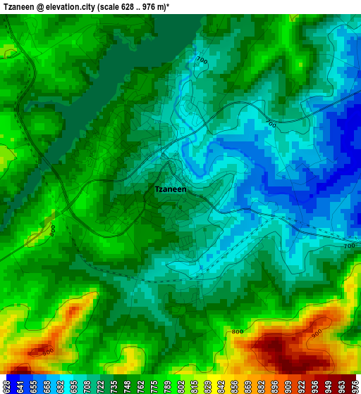
Below is the Elevation map of Tzaneen, which displays elevation range with different colors. Scale of the first map is from 628 to 976 m (2060 to 3202 ft) with average elevation of 744.9 meters (=2444 ft) [note 1]
These maps also provides idea of topography and contour of this city, they are displayed at different zoom levels. More info about maps, scale and edge coordinates you can find below images.
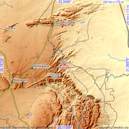
| \ | Map #1 | Map #2 | Topo.Map |
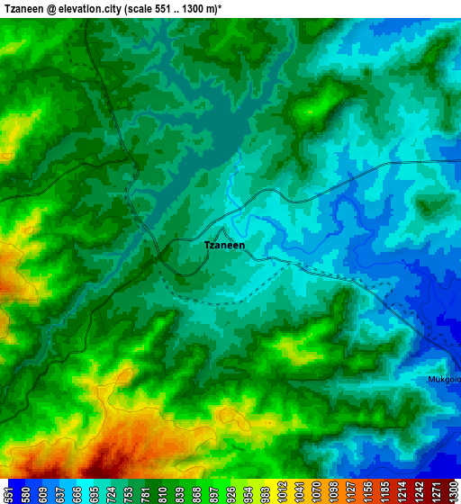
| Scale [m] | 628..976 m | 551..1300 m | × |
| Scale [ft] | 2060..3202 ft | 1808..4265 ft | × |
| Average | 744.9 m = 2444 ft | 783.3 m = 2570 ft | × |
| Width | 8.94 km = 5.6 mi | 17.88 km = 11.1 mi | 286 km = 177.7 mi |
| Height | 8.94 km = 5.6 mi | 17.88 km = 11.1 mi | 286 km = 177.7 mi |
| ↑Max Latitude | -23.793016° | -23.752799° | -22.5406° |
| Latitude at center | -23.83322° | -23.83322° | -23.83322° |
| ↓Min Latitude | -23.873412° | -23.913591° | -25.11309° |
| ← Min Longitude | 30.119565° | 30.075619° | 28.75726° |
| Longitude center | 30.16351° | 30.16351° | 30.16351° |
| →Max Longitude | 30.207455° | 30.251401° | 31.56976° |
Nearby cities:
Cities around Tzaneen sort by population:
• Polokwane elevation 1315 m
71.1 km,  263°
263°
• Phalaborwa 435 m
100.1 km,  97°
97°
• Louis Trichardt 956 m
91.7 km,  343°
343°
• Giyani 484 m
81.8 km,  43°
43°
• Lebowakgomo 1161 m
78.8 km,  238°
238°
• Nkowakowa 584 m
14 km,  115°
115°
• Duiwelskloof 875 m
15.7 km,  351°
351°
• Ga-Kgapane 774 m
21.9 km,  16°
16°
• Mankoeng 1389 m
36 km, 258°
• Hoedspruit 547 m
98.7 km,  125°
125°
• Burgersfort 761 m
95.1 km,  169°
169°
• Apel 768 m
77.1 km,  213°
213°
Multilingual:
 En español:
Tzaneen elevación 719 m.
 En France:
Tzaneen élévation 719 m.


Sources and notes:
- [note 1] Map square and city borders are not equal. Map elevation data is calculated only from area inside that square.
- [src 1] Elevation data from geonames database provided with same terms of usage.
- [src 2] The elevation map of Tzaneen is generated using elevation data from NASA's 3 arcsec (90m) resolution SRTM data.
- [src 3] Base (background) map © OpenStreetMap contributors tiles are generated by Geofabrik and OpenTopoMap.
Copyright & License:
This Tzaneen Elevation Map is licensed under CC BY-SA. You may reuse any part from this page, if you give a proper credit by linking to this URL:
 More info on terms of use page.