Cala elevation
Cala (Eastern Cape, Chris Hani District Municipality), South Africa elevation is 1196 meters and Cala elevation in feet is 3924 ft above sea level [src 1]. Cala is a seat of a third-order administrative division (feature code) with elevation that is 224 meters (735 ft) bigger than average city elevation in South Africa.
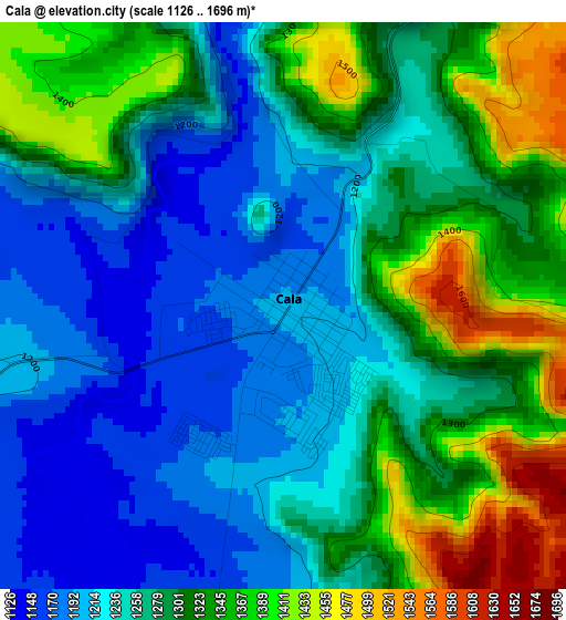
Below is the Elevation map of Cala, which displays elevation range with different colors. Scale of the first map is from 1126 to 1696 m (3694 to 5564 ft) with average elevation of 1282.5 meters (=4208 ft) [note 1]
These maps also provides idea of topography and contour of this city, they are displayed at different zoom levels. More info about maps, scale and edge coordinates you can find below images.
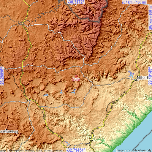
| \ | Map #1 | Topo.Map |
| Scale [m] | 1126..1696 m | × |
| Scale [ft] | 3694..5564 ft | × |
| Average | 1282.5 m = 4208 ft | × |
| Width | 8.33 km = 5.2 mi | 266.6 km = 165.7 mi |
| Height | 8.33 km = 5.2 mi | 266.6 km = 165.7 mi |
| ↑Max Latitude | -31.486092° | -30.3172° |
| Latitude at center | -31.52356° | -31.52356° |
| ↓Min Latitude | -31.561013° | -32.71454° |
| ← Min Longitude | 27.651255° | 26.28895° |
| Longitude center | 27.6952° | 27.6952° |
| →Max Longitude | 27.739145° | 29.10145° |
Nearby cities:
Cities around Cala sort by population:
• Queenstown elevation 1081 m
88 km,  241°
241°
• Mthatha 694 m
103.5 km,  94°
94°
• Butterworth 545 m
99.5 km,  154°
154°
• Lady Frere 1020 m
48.1 km,  245°
245°
• Queensdale 1205 m
78 km, 240°
• Elliot 1451 m
25.8 km,  34°
34°
• Ilinge 1107 m
79.7 km,  230°
230°
• Dordrecht 1620 m
63.6 km,  285°
285°
• Lady Grey 1647 m
101.2 km,  333°
333°
• Maclear 1262 m
80.1 km,  51°
51°
• Barkly East 1789 m
62.5 km,  351°
351°
• Cofimvaba 959 m
54.2 km,  191°
191°
Multilingual:
 En español:
Cala elevación 1196 m.
 En France:
Cala élévation 1196 m.


Sources and notes:
- [note 1] Map square and city borders are not equal. Map elevation data is calculated only from area inside that square.
- [src 1] Elevation data from geonames database provided with same terms of usage.
- [src 2] The elevation map of Cala is generated using elevation data from NASA's 3 arcsec (90m) resolution SRTM data.
- [src 3] Base (background) map © OpenStreetMap contributors tiles are generated by Geofabrik and OpenTopoMap.
Copyright & License:
This Cala Elevation Map is licensed under CC BY-SA. You may reuse any part from this page, if you give a proper credit by linking to this URL:
 More info on terms of use page.