Mthatha elevation
Mthatha (Eastern Cape, OR Tambo District Municipality), South Africa elevation is 694 meters and Mthatha elevation in feet is 2277 ft above sea level [src 1]. Mthatha is a populated place (feature code) with elevation that is 278 meters (912 ft) smaller than average city elevation in South Africa.
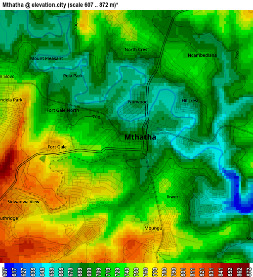
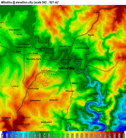
Below is the Elevation map of Mthatha, which displays elevation range with different colors. Scale of the first map is from 607 to 872 m (1991 to 2861 ft) with average elevation of 722.2 meters (=2369 ft) [note 1]
These maps also provides idea of topography and contour of this city, they are displayed at different zoom levels. More info about maps, scale and edge coordinates you can find below images.
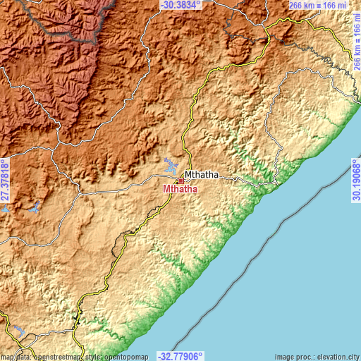
| \ | Map #1 | Map #2 | Topo.Map |
| Scale [m] | 607..872 m | 543..921 m | × |
| Scale [ft] | 1991..2861 ft | 1781..3022 ft | × |
| Average | 722.2 m = 2369 ft | 741.6 m = 2433 ft | × |
| Width | 8.32 km = 5.2 mi | 16.65 km = 10.3 mi | 266.4 km = 165.5 mi |
| Height | 8.32 km = 5.2 mi | 16.65 km = 10.3 mi | 266.4 km = 165.5 mi |
| ↑Max Latitude | -31.551489° | -31.514032° | -30.3834° |
| Latitude at center | -31.58893° | -31.58893° | -31.58893° |
| ↓Min Latitude | -31.626356° | -31.663768° | -32.77906° |
| ← Min Longitude | 28.740485° | 28.696539° | 27.37818° |
| Longitude center | 28.78443° | 28.78443° | 28.78443° |
| →Max Longitude | 28.828375° | 28.872321° | 30.19068° |
Nearby cities:
Cities around Mthatha sort by population:
• Butterworth elevation 545 m
101.9 km,  215°
215°
• Elliot 1451 m
93.1 km,  287°
287°
• Port Saint John’s 7 m
72.1 km,  93°
93°
• Bizana 828 m
130.1 km,  51°
51°
• Cofimvaba 959 m
122.7 km,  248°
248°
• Cala 1196 m
103.5 km,  274°
274°
• Mount Ayliff 1039 m
103 km,  32°
32°
• Flagstaff 907 m
88.1 km, 50°
• Mount Frere 1153 m
78.9 km,  14°
14°
• Maclear 1262 m
70.7 km,  324°
324°
• Qumbu 992 m
48.1 km, 9°
• Libode 792 m
22.6 km,  77°
77°
Multilingual:
 En español:
Mthatha elevación 694 m.
 En France:
Mthatha élévation 694 m.


Sources and notes:
- [note 1] Map square and city borders are not equal. Map elevation data is calculated only from area inside that square.
- [src 1] Elevation data from geonames database provided with same terms of usage.
- [src 2] The elevation map of Mthatha is generated using elevation data from NASA's 3 arcsec (90m) resolution SRTM data.
- [src 3] Base (background) map © OpenStreetMap contributors tiles are generated by Geofabrik and OpenTopoMap.
Copyright & License:
This Mthatha Elevation Map is licensed under CC BY-SA. You may reuse any part from this page, if you give a proper credit by linking to this URL:
 More info on terms of use page.