Lady Frere elevation
Lady Frere (Eastern Cape, Chris Hani District Municipality), South Africa elevation is 1020 meters and Lady Frere elevation in feet is 3346 ft above sea level [src 1]. Lady Frere is a seat of a third-order administrative division (feature code) with elevation that is 48 meters (157 ft) bigger than average city elevation in South Africa.
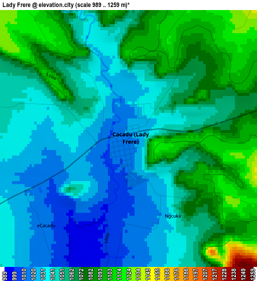
Below is the Elevation map of Lady Frere, which displays elevation range with different colors. Scale of the first map is from 989 to 1259 m (3245 to 4131 ft) with average elevation of 1056.5 meters (=3466 ft) [note 1]
These maps also provides idea of topography and contour of this city, they are displayed at different zoom levels. More info about maps, scale and edge coordinates you can find below images.
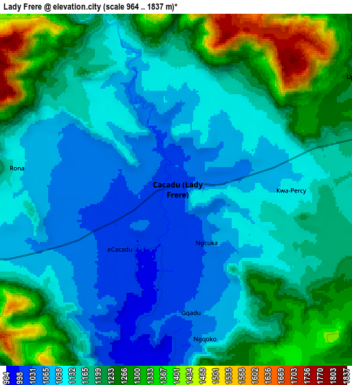
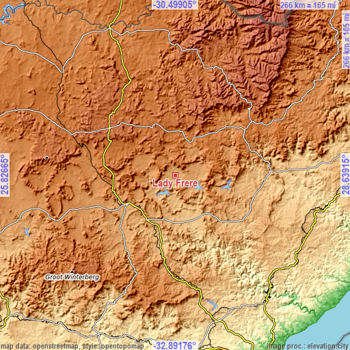
| \ | Map #1 | Map #2 | Topo.Map |
| Scale [m] | 989..1259 m | 964..1837 m | × |
| Scale [ft] | 3245..4131 ft | 3163..6027 ft | × |
| Average | 1056.5 m = 3466 ft | 1174 m = 3852 ft | × |
| Width | 8.31 km = 5.2 mi | 16.63 km = 10.3 mi | 266 km = 165.3 mi |
| Height | 8.31 km = 5.2 mi | 16.63 km = 10.3 mi | 266 km = 165.3 mi |
| ↑Max Latitude | -31.665725° | -31.628314° | -30.49905° |
| Latitude at center | -31.70312° | -31.70312° | -31.70312° |
| ↓Min Latitude | -31.7405° | -31.777866° | -32.89176° |
| ← Min Longitude | 27.188955° | 27.145009° | 25.82665° |
| Longitude center | 27.2329° | 27.2329° | 27.2329° |
| →Max Longitude | 27.276845° | 27.320791° | 28.63915° |
Nearby cities:
Cities around Lady Frere sort by population:
• Queenstown elevation 1081 m
40.1 km,  237°
237°
• Stutterheim 849 m
98.1 km,  169°
169°
• Queensdale 1205 m
30.4 km,  232°
232°
• Whittlesea 1062 m
65.2 km,  216°
216°
• Elliot 1451 m
71.5 km,  54°
54°
• Ilinge 1107 m
35.3 km,  210°
210°
• Molteno 1595 m
89.2 km,  292°
292°
• Dordrecht 1620 m
40.7 km,  334°
334°
• Tarkastad 1300 m
98 km,  249°
249°
• Barkly East 1789 m
88.7 km,  22°
22°
• Cala 1196 m
48.1 km,  65°
65°
• Cofimvaba 959 m
46.6 km,  135°
135°
Multilingual:
 En español:
Lady Frere elevación 1020 m.
 En France:
Lady Frere élévation 1020 m.
 Auf Deutsch:
Lady Frere höhe über dem Meeresspiegel ist 1020 m.

Sources and notes:
- [note 1] Map square and city borders are not equal. Map elevation data is calculated only from area inside that square.
- [src 1] Elevation data from geonames database provided with same terms of usage.
- [src 2] The elevation map of Lady Frere is generated using elevation data from NASA's 3 arcsec (90m) resolution SRTM data.
- [src 3] Base (background) map © OpenStreetMap contributors tiles are generated by Geofabrik and OpenTopoMap.
Copyright & License:
This Lady Frere Elevation Map is licensed under CC BY-SA. You may reuse any part from this page, if you give a proper credit by linking to this URL:
 More info on terms of use page.