Queenstown elevation
Queenstown (Eastern Cape, Chris Hani District Municipality), South Africa elevation is 1081 meters and Queenstown elevation in feet is 3547 ft above sea level [src 1]. Queenstown is a seat of a second-order administrative division (feature code) with elevation that is 109 meters (358 ft) bigger than average city elevation in South Africa.
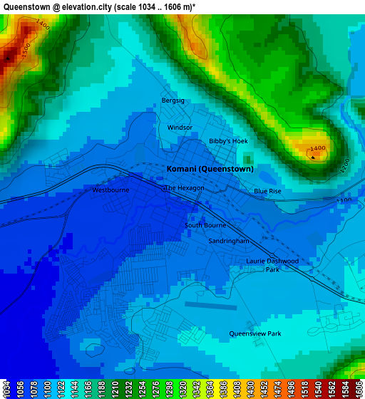
Below is the Elevation map of Queenstown, which displays elevation range with different colors. Scale of the first map is from 1034 to 1606 m (3392 to 5269 ft) with average elevation of 1141.3 meters (=3744 ft) [note 1]
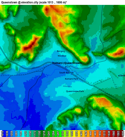
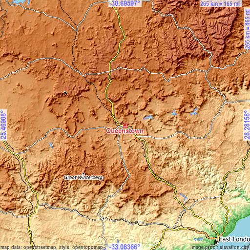
These maps also provides idea of topography and contour of this city, they are displayed at different zoom levels. More info about maps, scale and edge coordinates you can find below images.
| \ | Map #1 | Map #2 | Topo.Map |
| Scale [m] | 1034..1606 m | 1013..1606 m | × |
| Scale [ft] | 3392..5269 ft | 3323..5269 ft | × |
| Average | 1141.3 m = 3744 ft | 1170.2 m = 3839 ft | × |
| Width | 8.3 km = 5.2 mi | 16.59 km = 10.3 mi | 265.5 km = 165 mi |
| Height | 8.3 km = 5.2 mi | 16.59 km = 10.3 mi | 265.5 km = 165 mi |
| ↑Max Latitude | -31.860243° | -31.822911° | -30.69597° |
| Latitude at center | -31.89756° | -31.89756° | -31.89756° |
| ↓Min Latitude | -31.934862° | -31.972148° | -33.08366° |
| ← Min Longitude | 26.831385° | 26.787439° | 25.46908° |
| Longitude center | 26.87533° | 26.87533° | 26.87533° |
| →Max Longitude | 26.919275° | 26.963221° | 28.28158° |
Nearby cities:
Cities around Queenstown sort by population:
• Fort Beaufort elevation 444 m
100.1 km,  193°
193°
• Stutterheim 849 m
90.9 km,  145°
145°
• Lady Frere 1020 m
40.1 km,  57°
57°
• Queensdale 1205 m
10.2 km,  73°
73°
• Whittlesea 1062 m
31.3 km, 188°
• Ilinge 1107 m
18.1 km,  119°
119°
• Molteno 1595 m
73.9 km,  318°
318°
• Alice 522 m
99 km,  182°
182°
• Dordrecht 1620 m
60.7 km,  15°
15°
• Cala 1196 m
88 km, 61°
• Cofimvaba 959 m
67.5 km,  99°
99°
• Tarkastad 1300 m
59.4 km,  257°
257°
Multilingual:
 En español:
Queenstown elevación 1081 m.
 En France:
Queenstown élévation 1081 m.
 Auf Deutsch:
Queenstown höhe über dem Meeresspiegel ist 1081 m.
 На русском:
Квинстаун, Куинстаун высота над уровнем моря 1081 м
Sources and notes:
- [note 1] Map square and city borders are not equal. Map elevation data is calculated only from area inside that square.
- [src 1] Elevation data from geonames database provided with same terms of usage.
- [src 2] The elevation map of Queenstown is generated using elevation data from NASA's 3 arcsec (90m) resolution SRTM data.
- [src 3] Base (background) map © OpenStreetMap contributors tiles are generated by Geofabrik and OpenTopoMap.
Copyright & License:
This Queenstown Elevation Map is licensed under CC BY-SA. You may reuse any part from this page, if you give a proper credit by linking to this URL:
 More info on terms of use page.