Thulamahashi elevation
Thulamahashi (Limpopo), South Africa elevation is 488 meters and Thulamahashi elevation in feet is 1601 ft above sea level [src 1]. Thulamahashi is a populated place (feature code) with elevation that is 484 meters (1588 ft) smaller than average city elevation in South Africa.
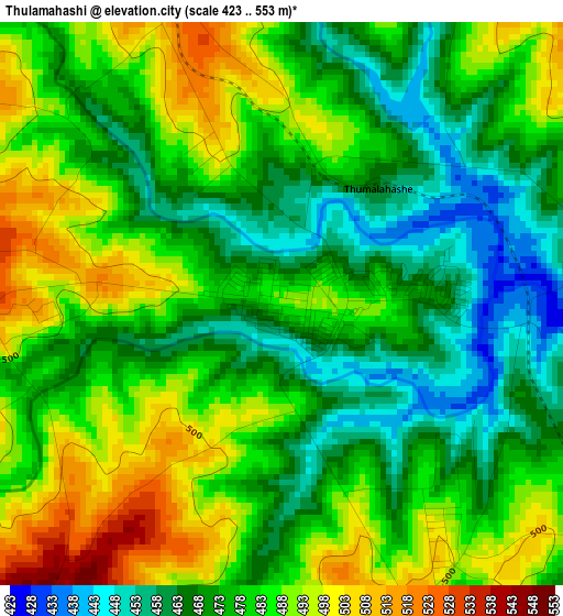
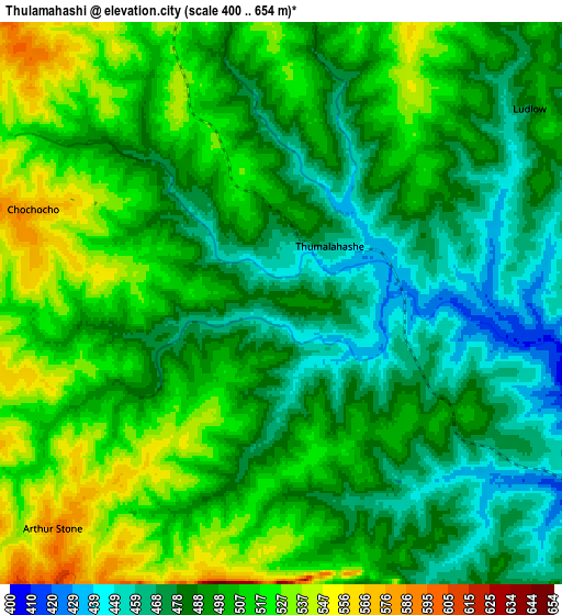
Below is the Elevation map of Thulamahashi, which displays elevation range with different colors. Scale of the first map is from 423 to 553 m (1388 to 1814 ft) with average elevation of 478.6 meters (=1570 ft) [note 1]
These maps also provides idea of topography and contour of this city, they are displayed at different zoom levels. More info about maps, scale and edge coordinates you can find below images.
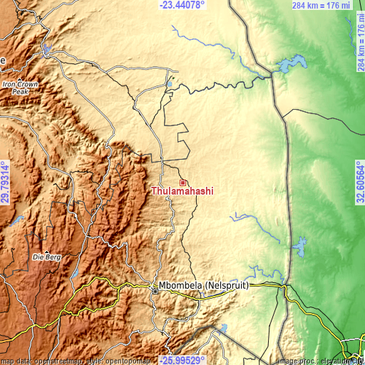
| \ | Map #1 | Map #2 | Topo.Map |
| Scale [m] | 423..553 m | 400..654 m | × |
| Scale [ft] | 1388..1814 ft | 1312..2146 ft | × |
| Average | 478.6 m = 1570 ft | 496.9 m = 1630 ft | × |
| Width | 8.88 km = 5.5 mi | 17.75 km = 11 mi | 284 km = 176.5 mi |
| Height | 8.88 km = 5.5 mi | 17.75 km = 11 mi | 284 km = 176.5 mi |
| ↑Max Latitude | -24.684667° | -24.644731° | -23.44078° |
| Latitude at center | -24.72459° | -24.72459° | -24.72459° |
| ↓Min Latitude | -24.7645° | -24.804398° | -25.99529° |
| ← Min Longitude | 31.155445° | 31.111499° | 29.79314° |
| Longitude center | 31.19939° | 31.19939° | 31.19939° |
| →Max Longitude | 31.243335° | 31.287281° | 32.60564° |
Nearby cities:
Cities around Thulamahashi sort by population:
• Nelspruit elevation 676 m
86.5 km,  195°
195°
• Phalaborwa 435 m
87.1 km,  356°
356°
• Barberton 853 m
119.2 km,  187°
187°
• Nkowakowa 584 m
131.2 km,  315°
315°
• Lydenburg 1371 m
86.7 km,  241°
241°
• Komatipoort 159 m
109.5 km,  136°
136°
• Tzaneen 719 m
144.4 km,  313°
313°
• White River 944 m
70.1 km, 195°
• Apel 768 m
150.6 km,  283°
283°
• Jane Furse 1420 m
134.3 km,  268°
268°
• Burgersfort 761 m
88.1 km, 273°
• Hoedspruit 547 m
48.4 km,  329°
329°
Multilingual:
 En español:
Thulamahashi elevación 488 m.
 En France:
Thulamahashi élévation 488 m.
 Auf Deutsch:
Thulamahashi höhe über dem Meeresspiegel ist 488 m.

Sources and notes:
- [note 1] Map square and city borders are not equal. Map elevation data is calculated only from area inside that square.
- [src 1] Elevation data from geonames database provided with same terms of usage.
- [src 2] The elevation map of Thulamahashi is generated using elevation data from NASA's 3 arcsec (90m) resolution SRTM data.
- [src 3] Base (background) map © OpenStreetMap contributors tiles are generated by Geofabrik and OpenTopoMap.
Copyright & License:
This Thulamahashi Elevation Map is licensed under CC BY-SA. You may reuse any part from this page, if you give a proper credit by linking to this URL:
 More info on terms of use page.