Nelspruit elevation
Nelspruit (Mpumalanga, Ehlanzeni District), South Africa elevation is 676 meters and Nelspruit elevation in feet is 2218 ft above sea level [src 1]. Nelspruit is a seat of a first-order administrative division (feature code) with elevation that is 296 meters (971 ft) smaller than average city elevation in South Africa.
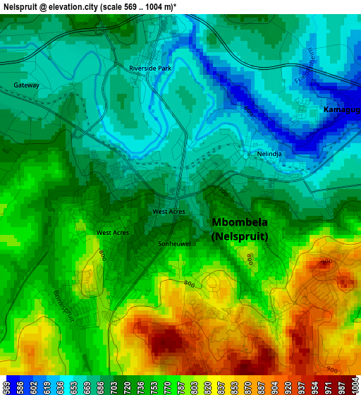
Below is the Elevation map of Nelspruit, which displays elevation range with different colors. Scale of the first map is from 569 to 1004 m (1867 to 3294 ft) with average elevation of 731.3 meters (=2399 ft) [note 1]
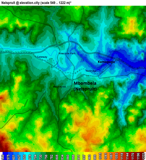
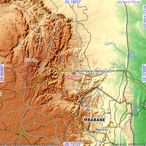
These maps also provides idea of topography and contour of this city, they are displayed at different zoom levels. More info about maps, scale and edge coordinates you can find below images.
| \ | Map #1 | Map #2 | Topo.Map |
| Scale [m] | 569..1004 m | 549..1222 m | × |
| Scale [ft] | 1867..3294 ft | 1801..4009 ft | × |
| Average | 731.3 m = 2399 ft | 785.8 m = 2578 ft | × |
| Width | 8.82 km = 5.5 mi | 17.64 km = 11 mi | 282.3 km = 175.4 mi |
| Height | 8.82 km = 5.5 mi | 17.64 km = 11 mi | 282.3 km = 175.4 mi |
| ↑Max Latitude | -25.434801° | -25.395108° | -24.19833° |
| Latitude at center | -25.47448° | -25.47448° | -25.47448° |
| ↓Min Latitude | -25.514146° | -25.553799° | -26.73723° |
| ← Min Longitude | 30.926385° | 30.882439° | 29.56408° |
| Longitude center | 30.97033° | 30.97033° | 30.97033° |
| →Max Longitude | 31.014275° | 31.058221° | 32.37658° |
Nearby cities:
Cities around Nelspruit sort by population:
• Barberton elevation 853 m
35.9 km,  166°
166°
• Lydenburg 1371 m
67.6 km,  308°
308°
• Komatipoort 159 m
98.9 km,  87°
87°
• White River 944 m
16.4 km,  14°
14°
• Hendrina 1686 m
146.9 km,  238°
238°
• Breyten 1753 m
134.7 km,  226°
226°
• Belfast 1873 m
96.8 km,  255°
255°
• Thulamahashi 488 m
86.5 km,  15°
15°
• Carolina 1698 m
108.2 km, 232°
• Jane Furse 1420 m
136.3 km, 305°
• Hoedspruit 547 m
124.9 km,  359°
359°
• Burgersfort 761 m
109.8 km,  323°
323°
Multilingual:
 En español:
Nelspruit elevación 676 m.
 En France:
Nelspruit élévation 676 m.
 Auf Deutsch:
Mbombela höhe über dem Meeresspiegel ist 676 m.

Sources and notes:
- [note 1] Map square and city borders are not equal. Map elevation data is calculated only from area inside that square.
- [src 1] Elevation data from geonames database provided with same terms of usage.
- [src 2] The elevation map of Nelspruit is generated using elevation data from NASA's 3 arcsec (90m) resolution SRTM data.
- [src 3] Base (background) map © OpenStreetMap contributors tiles are generated by Geofabrik and OpenTopoMap.
Copyright & License:
This Nelspruit Elevation Map is licensed under CC BY-SA. You may reuse any part from this page, if you give a proper credit by linking to this URL:
 More info on terms of use page.