Belfast elevation
Belfast (Mpumalanga, Nkangala District Municipality), South Africa elevation is 1873 meters and Belfast elevation in feet is 6145 ft above sea level [src 1]. Belfast is a seat of a third-order administrative division (feature code) with elevation that is 901 meters (2956 ft) bigger than average city elevation in South Africa.
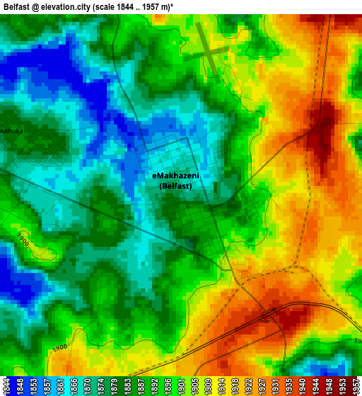
Below is the Elevation map of Belfast, which displays elevation range with different colors. Scale of the first map is from 1844 to 1957 m (6050 to 6421 ft) with average elevation of 1893 meters (=6211 ft) [note 1]
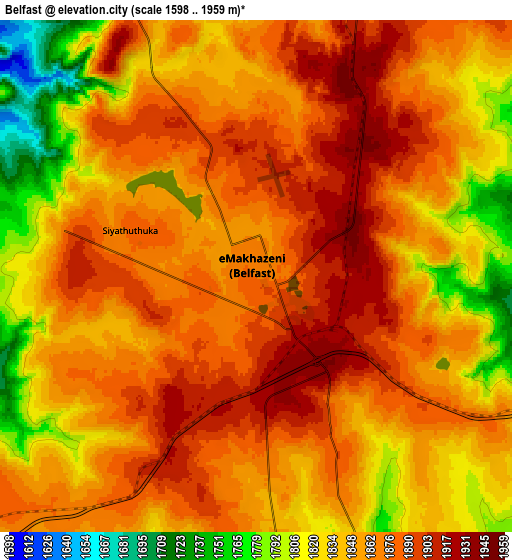
These maps also provides idea of topography and contour of this city, they are displayed at different zoom levels. More info about maps, scale and edge coordinates you can find below images.
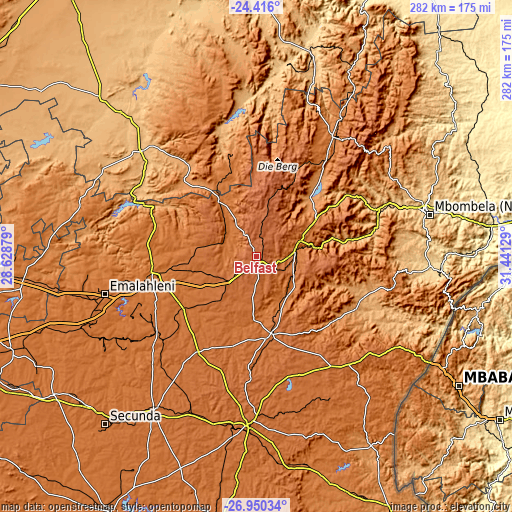
| \ | Map #1 | Map #2 | Topo.Map |
| Scale [m] | 1844..1957 m | 1598..1959 m | × |
| Scale [ft] | 6050..6421 ft | 5243..6427 ft | × |
| Average | 1893 m = 6211 ft | 1856.3 m = 6090 ft | × |
| Width | 8.81 km = 5.5 mi | 17.61 km = 10.9 mi | 281.8 km = 175.1 mi |
| Height | 8.81 km = 5.5 mi | 17.61 km = 10.9 mi | 281.8 km = 175.1 mi |
| ↑Max Latitude | -25.650302° | -25.610681° | -24.416° |
| Latitude at center | -25.68991° | -25.68991° | -25.68991° |
| ↓Min Latitude | -25.729505° | -25.769087° | -26.95034° |
| ← Min Longitude | 29.991095° | 29.947149° | 28.62879° |
| Longitude center | 30.03504° | 30.03504° | 30.03504° |
| →Max Longitude | 30.078985° | 30.122931° | 31.44129° |
Nearby cities:
Cities around Belfast sort by population:
• Witbank elevation 1629 m
82.8 km,  255°
255°
• Middelburg 1479 m
57.9 km, 260°
• Nelspruit 676 m
96.8 km,  75°
75°
• Bethal 1661 m
102.6 km,  213°
213°
• Barberton 853 m
102.6 km,  96°
96°
• Ermelo 1700 m
93.9 km,  183°
183°
• Lydenburg 1371 m
77.8 km,  31°
31°
• Hendrina 1686 m
61.2 km, 211°
• Kriel 1552 m
103.8 km,  231°
231°
• Breyten 1753 m
68.2 km, 184°
• Carolina 1698 m
42.9 km,  169°
169°
• Groblersdal 928 m
86.6 km,  312°
312°
Multilingual:
 En español:
Belfast elevación 1873 m.
 En France:
Belfast élévation 1873 m.
 Auf Deutsch:
Belfast höhe über dem Meeresspiegel ist 1873 m.

Sources and notes:
- [note 1] Map square and city borders are not equal. Map elevation data is calculated only from area inside that square.
- [src 1] Elevation data from geonames database provided with same terms of usage.
- [src 2] The elevation map of Belfast is generated using elevation data from NASA's 3 arcsec (90m) resolution SRTM data.
- [src 3] Base (background) map © OpenStreetMap contributors tiles are generated by Geofabrik and OpenTopoMap.
Copyright & License:
This Belfast Elevation Map is licensed under CC BY-SA. You may reuse any part from this page, if you give a proper credit by linking to this URL:
 More info on terms of use page.