Vrede elevation
Vrede (Orange Free State, Thabo Mofutsanyana District Municipality), South Africa elevation is 1678 meters and Vrede elevation in feet is 5505 ft above sea level [src 1]. Vrede is a seat of a third-order administrative division (feature code) with elevation that is 706 meters (2316 ft) bigger than average city elevation in South Africa.
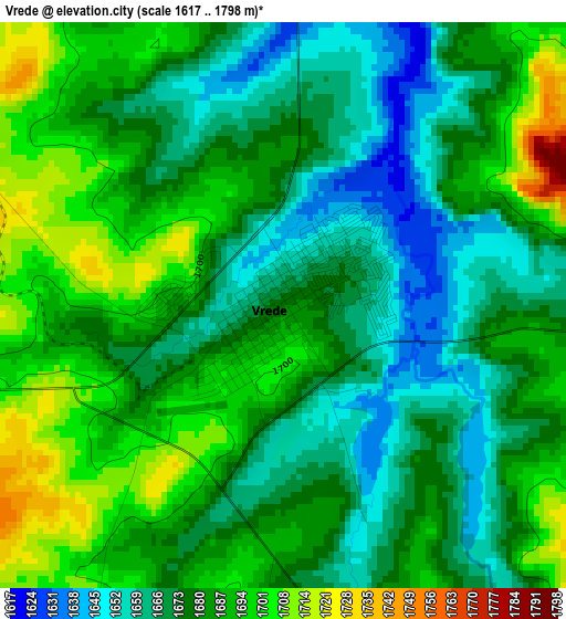
Below is the Elevation map of Vrede, which displays elevation range with different colors. Scale of the first map is from 1617 to 1798 m (5305 to 5899 ft) with average elevation of 1679.7 meters (=5511 ft) [note 1]
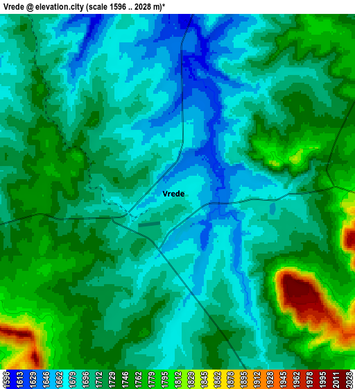
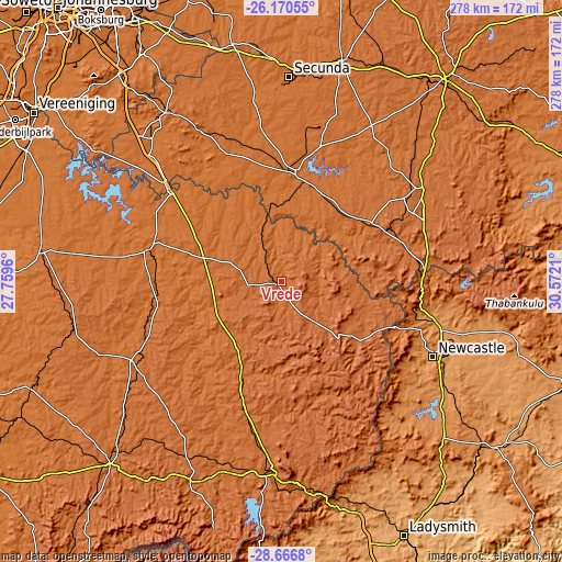
These maps also provides idea of topography and contour of this city, they are displayed at different zoom levels. More info about maps, scale and edge coordinates you can find below images.
| \ | Map #1 | Map #2 | Topo.Map |
| Scale [m] | 1617..1798 m | 1596..2028 m | × |
| Scale [ft] | 5305..5899 ft | 5236..6654 ft | × |
| Average | 1679.7 m = 5511 ft | 1716.6 m = 5632 ft | × |
| Width | 8.67 km = 5.4 mi | 17.35 km = 10.8 mi | 277.6 km = 172.5 mi |
| Height | 8.67 km = 5.4 mi | 17.35 km = 10.8 mi | 277.6 km = 172.5 mi |
| ↑Max Latitude | -27.386717° | -27.34769° | -26.17055° |
| Latitude at center | -27.42573° | -27.42573° | -27.42573° |
| ↓Min Latitude | -27.464729° | -27.503715° | -28.6668° |
| ← Min Longitude | 29.121905° | 29.077959° | 27.7596° |
| Longitude center | 29.16585° | 29.16585° | 29.16585° |
| →Max Longitude | 29.209795° | 29.253741° | 30.5721° |
Nearby cities:
Cities around Vrede sort by population:
• Newcastle elevation 1195 m
84 km,  116°
116°
• eMbalenhle 1575 m
99.7 km,  354°
354°
• Bethal 1661 m
111.6 km,  15°
15°
• Standerton 1569 m
55.2 km,  7°
7°
• Balfour 1622 m
102.2 km,  326°
326°
• Volksrust 1664 m
71 km,  84°
84°
• Harrismith 1643 m
94.2 km,  182°
182°
• Secunda 1592 m
97.4 km,  0°
0°
• Reitz 1643 m
83.9 km,  240°
240°
• Villiers 1517 m
71.1 km,  308°
308°
• Frankfort 1545 m
68 km,  283°
283°
• Dannhauser 1359 m
109.5 km,  126°
126°
Multilingual:
 En español:
Vrede elevación 1678 m.
 En France:
Vrede élévation 1678 m.


Sources and notes:
- [note 1] Map square and city borders are not equal. Map elevation data is calculated only from area inside that square.
- [src 1] Elevation data from geonames database provided with same terms of usage.
- [src 2] The elevation map of Vrede is generated using elevation data from NASA's 3 arcsec (90m) resolution SRTM data.
- [src 3] Base (background) map © OpenStreetMap contributors tiles are generated by Geofabrik and OpenTopoMap.
Copyright & License:
This Vrede Elevation Map is licensed under CC BY-SA. You may reuse any part from this page, if you give a proper credit by linking to this URL:
 More info on terms of use page.