Villiers elevation
Villiers (Orange Free State, Fezile Dabi District Municipality), South Africa elevation is 1517 meters and Villiers elevation in feet is 4977 ft above sea level [src 1]. Villiers is a populated place (feature code) with elevation that is 545 meters (1788 ft) bigger than average city elevation in South Africa.
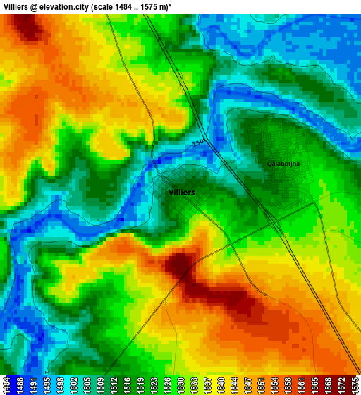
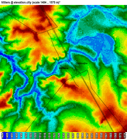
Below is the Elevation map of Villiers, which displays elevation range with different colors. Scale of the first map is from 1484 to 1575 m (4869 to 5167 ft) with average elevation of 1525.2 meters (=5004 ft) [note 1]
These maps also provides idea of topography and contour of this city, they are displayed at different zoom levels. More info about maps, scale and edge coordinates you can find below images.
| \ | Map #1 | Map #2 | Topo.Map |
| Scale [m] | 1484..1575 m | 1484..1575 m | × |
| Scale [ft] | 4869..5167 ft | 4869..5167 ft | × |
| Average | 1525.2 m = 5004 ft | 1524.8 m = 5003 ft | × |
| Width | 8.7 km = 5.4 mi | 17.41 km = 10.8 mi | 278.5 km = 173.1 mi |
| Height | 8.71 km = 5.4 mi | 17.41 km = 10.8 mi | 278.6 km = 173.1 mi |
| ↑Max Latitude | -26.991108° | -26.951943° | -25.77071° |
| Latitude at center | -27.03026° | -27.03026° | -27.03026° |
| ↓Min Latitude | -27.069398° | -27.108523° | -28.27584° |
| ← Min Longitude | 28.556665° | 28.512719° | 27.19436° |
| Longitude center | 28.60061° | 28.60061° | 28.60061° |
| →Max Longitude | 28.644555° | 28.688501° | 30.00686° |
Nearby cities:
Cities around Villiers sort by population:
• Vereeniging elevation 1445 m
77.8 km,  300°
300°
• eMbalenhle 1575 m
72.1 km,  39°
39°
• Nigel 1566 m
67.7 km,  349°
349°
• Standerton 1569 m
64.4 km,  80°
80°
• Heidelberg 1525 m
63.2 km,  337°
337°
• Heilbron 1539 m
68.3 km,  245°
245°
• Balfour 1622 m
40.8 km,  358°
358°
• Secunda 1592 m
77.5 km,  46°
46°
• Vrede 1678 m
71.1 km,  128°
128°
• Deneysville 1513 m
52.3 km,  287°
287°
• Frankfort 1545 m
29.5 km,  200°
200°
• Meyerton 1473 m
77.9 km,  312°
312°
Multilingual:
 En español:
Villiers elevación 1517 m.
 En France:
Villiers élévation 1517 m.
 Auf Deutsch:
Villiers höhe über dem Meeresspiegel ist 1517 m.

Sources and notes:
- [note 1] Map square and city borders are not equal. Map elevation data is calculated only from area inside that square.
- [src 1] Elevation data from geonames database provided with same terms of usage.
- [src 2] The elevation map of Villiers is generated using elevation data from NASA's 3 arcsec (90m) resolution SRTM data.
- [src 3] Base (background) map © OpenStreetMap contributors tiles are generated by Geofabrik and OpenTopoMap.
Copyright & License:
This Villiers Elevation Map is licensed under CC BY-SA. You may reuse any part from this page, if you give a proper credit by linking to this URL:
 More info on terms of use page.