Harrismith elevation
Harrismith (Orange Free State, Thabo Mofutsanyana District Municipality), South Africa elevation is 1643 meters and Harrismith elevation in feet is 5390 ft above sea level [src 1]. Harrismith is a populated place (feature code) with elevation that is 671 meters (2201 ft) bigger than average city elevation in South Africa.
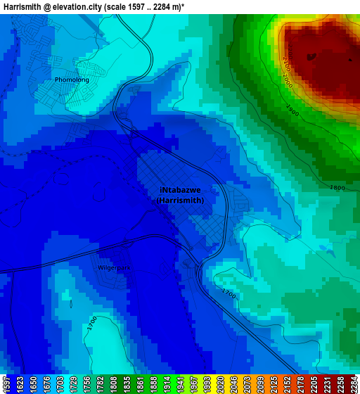
Below is the Elevation map of Harrismith, which displays elevation range with different colors. Scale of the first map is from 1597 to 2284 m (5240 to 7493 ft) with average elevation of 1714 meters (=5623 ft) [note 1]
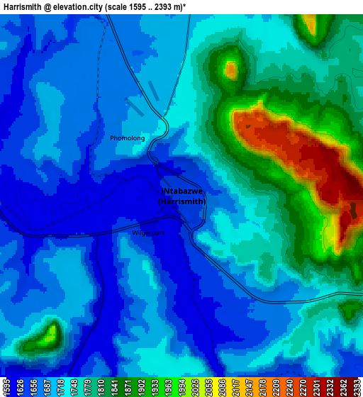
These maps also provides idea of topography and contour of this city, they are displayed at different zoom levels. More info about maps, scale and edge coordinates you can find below images.
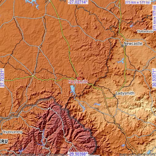
| \ | Map #1 | Map #2 | Topo.Map |
| Scale [m] | 1597..2284 m | 1595..2393 m | × |
| Scale [ft] | 5240..7493 ft | 5233..7851 ft | × |
| Average | 1714 m = 5623 ft | 1742.4 m = 5717 ft | × |
| Width | 8.61 km = 5.3 mi | 17.21 km = 10.7 mi | 275.4 km = 171.1 mi |
| Height | 8.61 km = 5.3 mi | 17.21 km = 10.7 mi | 275.4 km = 171.1 mi |
| ↑Max Latitude | -28.23405° | -28.195326° | -27.02714° |
| Latitude at center | -28.27276° | -28.27276° | -28.27276° |
| ↓Min Latitude | -28.311456° | -28.350137° | -29.50398° |
| ← Min Longitude | 29.085515° | 29.041569° | 27.72321° |
| Longitude center | 29.12946° | 29.12946° | 29.12946° |
| →Max Longitude | 29.173405° | 29.217351° | 30.53571° |
Nearby cities:
Cities around Harrismith sort by population:
• Newcastle elevation 1195 m
97.4 km,  53°
53°
• Dundee 1260 m
108.8 km,  83°
83°
• Phuthaditjhaba 1671 m
41.5 km,  227°
227°
• Bethlehem 1630 m
80.7 km,  273°
273°
• Reitz 1643 m
86.6 km,  307°
307°
• Vrede 1678 m
94.2 km,  2°
2°
• Ekuvukeni 1006 m
102.7 km,  102°
102°
• Glencoe 1293 m
100.2 km, 83°
• Estcourt 1214 m
109.3 km,  138°
138°
• Dannhauser 1359 m
95.3 km,  72°
72°
• Ladysmith 1010 m
71 km,  116°
116°
• Bergville 1139 m
55.4 km,  156°
156°
Multilingual:
 En español:
Harrismith elevación 1643 m.
 En France:
Harrismith élévation 1643 m.
 Auf Deutsch:
Harrismith höhe über dem Meeresspiegel ist 1643 m.

Sources and notes:
- [note 1] Map square and city borders are not equal. Map elevation data is calculated only from area inside that square.
- [src 1] Elevation data from geonames database provided with same terms of usage.
- [src 2] The elevation map of Harrismith is generated using elevation data from NASA's 3 arcsec (90m) resolution SRTM data.
- [src 3] Base (background) map © OpenStreetMap contributors tiles are generated by Geofabrik and OpenTopoMap.
Copyright & License:
This Harrismith Elevation Map is licensed under CC BY-SA. You may reuse any part from this page, if you give a proper credit by linking to this URL:
 More info on terms of use page.