Al Khamīs elevation
Al Khamīs (Al Maḩwīt, Bani Sa'd), Yemen elevation is 493 meters and Al Khamīs elevation in feet is 1617 ft above sea level [src 1]. Al Khamīs is a seat of a second-order administrative division (feature code) with elevation that is 819 meters (2687 ft) smaller than average city elevation in Yemen.
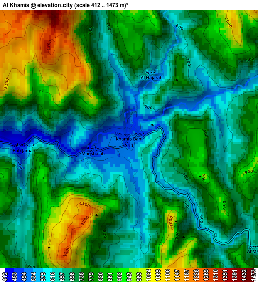
Below is the Elevation map of Al Khamīs, which displays elevation range with different colors. Scale of the first map is from 412 to 1473 m (1352 to 4833 ft) with average elevation of 766.6 meters (=2515 ft) [note 1]
These maps also provides idea of topography and contour of this city, they are displayed at different zoom levels. More info about maps, scale and edge coordinates you can find below images.
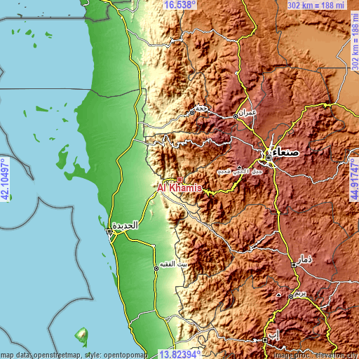
| \ | Map #1 | Topo.Map |
| Scale [m] | 412..1473 m | × |
| Scale [ft] | 1352..4833 ft | × |
| Average | 766.6 m = 2515 ft | × |
| Width | 9.43 km = 5.9 mi | 301.8 km = 187.5 mi |
| Height | 9.43 km = 5.9 mi | 301.8 km = 187.5 mi |
| ↑Max Latitude | 15.227737° | 16.538° |
| Latitude at center | 15.18533° | 15.18533° |
| ↓Min Latitude | 15.142915° | 13.82394° |
| ← Min Longitude | 43.467275° | 42.10497° |
| Longitude center | 43.51122° | 43.51122° |
| →Max Longitude | 43.555165° | 44.91747° |
Nearby cities:
Cities around Al Khamīs sort by population:
• Bājil elevation 191 m
27.8 km,  239°
239°
• Al Maḩwīt 2124 m
31.9 km,  6°
6°
• Markaz Bilād aţ Ţa‘ām 1689 m
39.2 km,  176°
176°
• Al Mighlāf 132 m
36.4 km,  288°
288°
• Riqāb 1949 m
33.7 km,  188°
188°
• Al Mirwāḩ 1213 m
33.1 km,  344°
344°
• Banī Ḩujjāj 745 m
33 km,  321°
321°
• Ar Rujum 1958 m
33 km,  23°
23°
• Manākhah 2263 m
27.6 km,  116°
116°
• Aş Şafaqayn 2157 m
23.7 km, 335°
• ‘Ubāl 494 m
22.2 km,  170°
170°
• Matwaḩ 2152 m
19.2 km,  132°
132°
Multilingual:
 En español:
Al Khamīs elevación 493 m.
 En France:
Al Khamīs élévation 493 m.
 Auf Deutsch:
Al Khamīs höhe über dem Meeresspiegel ist 493 m.

Sources and notes:
- [note 1] Map square and city borders are not equal. Map elevation data is calculated only from area inside that square.
- [src 1] Elevation data from geonames database provided with same terms of usage.
- [src 2] The elevation map of Al Khamīs is generated using elevation data from NASA's 3 arcsec (90m) resolution SRTM data.
- [src 3] Base (background) map © OpenStreetMap contributors tiles are generated by Geofabrik and OpenTopoMap.
Copyright & License:
This Al Khamīs Elevation Map is licensed under CC BY-SA. You may reuse any part from this page, if you give a proper credit by linking to this URL:
 More info on terms of use page.