Manākhah elevation
Manākhah (Sanaa, Manakhah), Yemen elevation is 2263 meters and Manākhah elevation in feet is 7425 ft above sea level [src 1]. Manākhah is a seat of a second-order administrative division (feature code) with elevation that is 951 meters (3120 ft) bigger than average city elevation in Yemen.
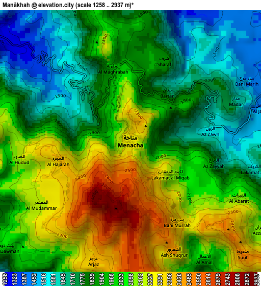
Below is the Elevation map of Manākhah, which displays elevation range with different colors. Scale of the first map is from 1258 to 2937 m (4127 to 9636 ft) with average elevation of 1967.6 meters (=6455 ft) [note 1]
These maps also provides idea of topography and contour of this city, they are displayed at different zoom levels. More info about maps, scale and edge coordinates you can find below images.
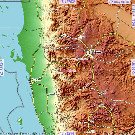
| \ | Map #1 | Topo.Map |
| Scale [m] | 1258..2937 m | × |
| Scale [ft] | 4127..9636 ft | × |
| Average | 1967.6 m = 6455 ft | × |
| Width | 9.44 km = 5.9 mi | 301.9 km = 187.6 mi |
| Height | 9.44 km = 5.9 mi | 302 km = 187.7 mi |
| ↑Max Latitude | 15.116649° | 16.42763° |
| Latitude at center | 15.07422° | 15.07422° |
| ↓Min Latitude | 15.031783° | 13.71214° |
| ← Min Longitude | 43.697615° | 42.33531° |
| Longitude center | 43.74156° | 43.74156° |
| →Max Longitude | 43.785505° | 45.14781° |
Nearby cities:
Cities around Manākhah sort by population:
• As Sukhnah elevation 247 m
45.2 km,  226°
226°
• Al Jum‘ah 2153 m
44.4 km,  147°
147°
• Ar Rujum 1958 m
44.2 km,  344°
344°
• Al Jabīn 2427 m
43.9 km,  200°
200°
• Riqāb 1949 m
36.3 km, 234°
• Matnah 2791 m
36.3 km,  56°
56°
• Markaz Bilād aţ Ţa‘ām 1689 m
34.7 km,  219°
219°
• Al Khamīs 493 m
27.6 km,  296°
296°
• Al ‘Urr 2019 m
24.8 km,  39°
39°
• ‘Ubāl 494 m
23.2 km,  245°
245°
• Mafḩaq 1646 m
17.6 km,  80°
80°
• Matwaḩ 2152 m
10.7 km,  266°
266°
Multilingual:
 En español:
Manākhah elevación 2263 m.
 En France:
Manākhah élévation 2263 m.
 Auf Deutsch:
Manākhah höhe über dem Meeresspiegel ist 2263 m.

Sources and notes:
- [note 1] Map square and city borders are not equal. Map elevation data is calculated only from area inside that square.
- [src 1] Elevation data from geonames database provided with same terms of usage.
- [src 2] The elevation map of Manākhah is generated using elevation data from NASA's 3 arcsec (90m) resolution SRTM data.
- [src 3] Base (background) map © OpenStreetMap contributors tiles are generated by Geofabrik and OpenTopoMap.
Copyright & License:
This Manākhah Elevation Map is licensed under CC BY-SA. You may reuse any part from this page, if you give a proper credit by linking to this URL:
 More info on terms of use page.