Al Maḩwīt elevation
Al Maḩwīt, Yemen elevation is 2124 meters and Al Maḩwīt elevation in feet is 6969 ft above sea level [src 1]. Al Maḩwīt is a seat of a first-order administrative division (feature code) with elevation that is 812 meters (2664 ft) bigger than average city elevation in Yemen.
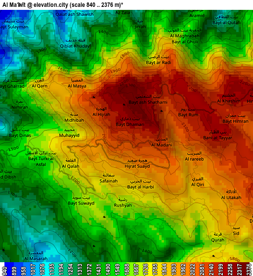
Below is the Elevation map of Al Maḩwīt, which displays elevation range with different colors. Scale of the first map is from 840 to 2376 m (2756 to 7795 ft) with average elevation of 1698.2 meters (=5572 ft) [note 1]
These maps also provides idea of topography and contour of this city, they are displayed at different zoom levels. More info about maps, scale and edge coordinates you can find below images.
| \ | Map #1 | Map #2 | Topo.Map |
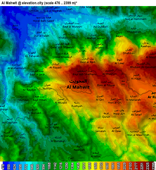
| Scale [m] | 840..2376 m | 476..2399 m | × |
| Scale [ft] | 2756..7795 ft | 1562..7871 ft | × |
| Average | 1698.2 m = 5572 ft | 1332.2 m = 4371 ft | × |
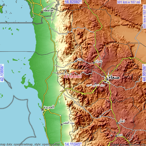
| Width | 9.42 km = 5.9 mi | 18.84 km = 11.7 mi | 301.4 km = 187.3 mi |
| Height | 9.42 km = 5.9 mi | 18.84 km = 11.7 mi | 301.4 km = 187.3 mi |
| ↑Max Latitude | 15.512419° | 15.554759° | 16.82082° |
| Latitude at center | 15.47007° | 15.47007° | 15.47007° |
| ↓Min Latitude | 15.427713° | 15.385346° | 14.11045° |
| ← Min Longitude | 43.500865° | 43.456919° | 42.13856° |
| Longitude center | 43.54481° | 43.54481° | 43.54481° |
| →Max Longitude | 43.588755° | 43.632701° | 44.95106° |
Nearby cities:
Cities around Al Maḩwīt sort by population:
• Ḩajjah elevation 1795 m
25.8 km,  14°
14°
• Banī al ‘Awwām 1528 m
13.2 km,  20°
20°
• Sharas 1024 m
29.2 km, 22°
• Waḑarah 1316 m
27.6 km,  346°
346°
• Banī Ḩujjāj 745 m
24.9 km,  256°
256°
• Bayt ‘Adhāqah 2575 m
23.4 km,  46°
46°
• Aţ Ţawīlah 2603 m
21.9 km,  83°
83°
• Banī an Nahārī 1703 m
18.9 km,  3°
3°
• Ash Shaghādirah 1283 m
16.9 km, 351°
• Aş Şafaqayn 2157 m
16.7 km,  232°
232°
• Al Mirwāḩ 1213 m
12.4 km,  271°
271°
• Ar Rujum 1958 m
9.5 km,  98°
98°
Multilingual:
 En español:
Al Maḩwīt elevación 2124 m.
 En France:
Al Maḩwīt élévation 2124 m.
 Auf Deutsch:
Al Maḩwīt höhe über dem Meeresspiegel ist 2124 m.

Sources and notes:
- [note 1] Map square and city borders are not equal. Map elevation data is calculated only from area inside that square.
- [src 1] Elevation data from geonames database provided with same terms of usage.
- [src 2] The elevation map of Al Maḩwīt is generated using elevation data from NASA's 3 arcsec (90m) resolution SRTM data.
- [src 3] Base (background) map © OpenStreetMap contributors tiles are generated by Geofabrik and OpenTopoMap.
Copyright & License:
This Al Maḩwīt Elevation Map is licensed under CC BY-SA. You may reuse any part from this page, if you give a proper credit by linking to this URL:
 More info on terms of use page.